Home PageAbout MindatThe Mindat ManualHistory of MindatCopyright StatusWho We AreContact UsAdvertise on Mindat
Donate to MindatCorporate SponsorshipSponsor a PageSponsored PagesMindat AdvertisersAdvertise on Mindat
Learning CenterWhat is a mineral?The most common minerals on earthInformation for EducatorsMindat ArticlesThe ElementsThe Rock H. Currier Digital LibraryGeologic Time
Minerals by PropertiesMinerals by ChemistryAdvanced Locality SearchRandom MineralRandom LocalitySearch by minIDLocalities Near MeSearch ArticlesSearch GlossaryMore Search Options
The Mindat ManualAdd a New PhotoRate PhotosLocality Edit ReportCoordinate Completion ReportAdd Glossary Item
Mining CompaniesStatisticsUsersMineral MuseumsClubs & OrganizationsMineral Shows & EventsThe Mindat DirectoryDevice SettingsThe Mineral Quiz
Photo SearchPhoto GalleriesSearch by ColorNew Photos TodayNew Photos YesterdayMembers' Photo GalleriesPast Photo of the Day GalleryPhotography
╳Discussions
💬 Home🔎 Search📅 LatestGroups
EducationOpen discussion area.Fakes & FraudsOpen discussion area.Field CollectingOpen discussion area.FossilsOpen discussion area.Gems and GemologyOpen discussion area.GeneralOpen discussion area.How to ContributeOpen discussion area.Identity HelpOpen discussion area.Improving Mindat.orgOpen discussion area.LocalitiesOpen discussion area.Lost and Stolen SpecimensOpen discussion area.MarketplaceOpen discussion area.MeteoritesOpen discussion area.Mindat ProductsOpen discussion area.Mineral ExchangesOpen discussion area.Mineral PhotographyOpen discussion area.Mineral ShowsOpen discussion area.Mineralogical ClassificationOpen discussion area.Mineralogy CourseOpen discussion area.MineralsOpen discussion area.Minerals and MuseumsOpen discussion area.PhotosOpen discussion area.Techniques for CollectorsOpen discussion area.The Rock H. Currier Digital LibraryOpen discussion area.UV MineralsOpen discussion area.Recent Images in Discussions


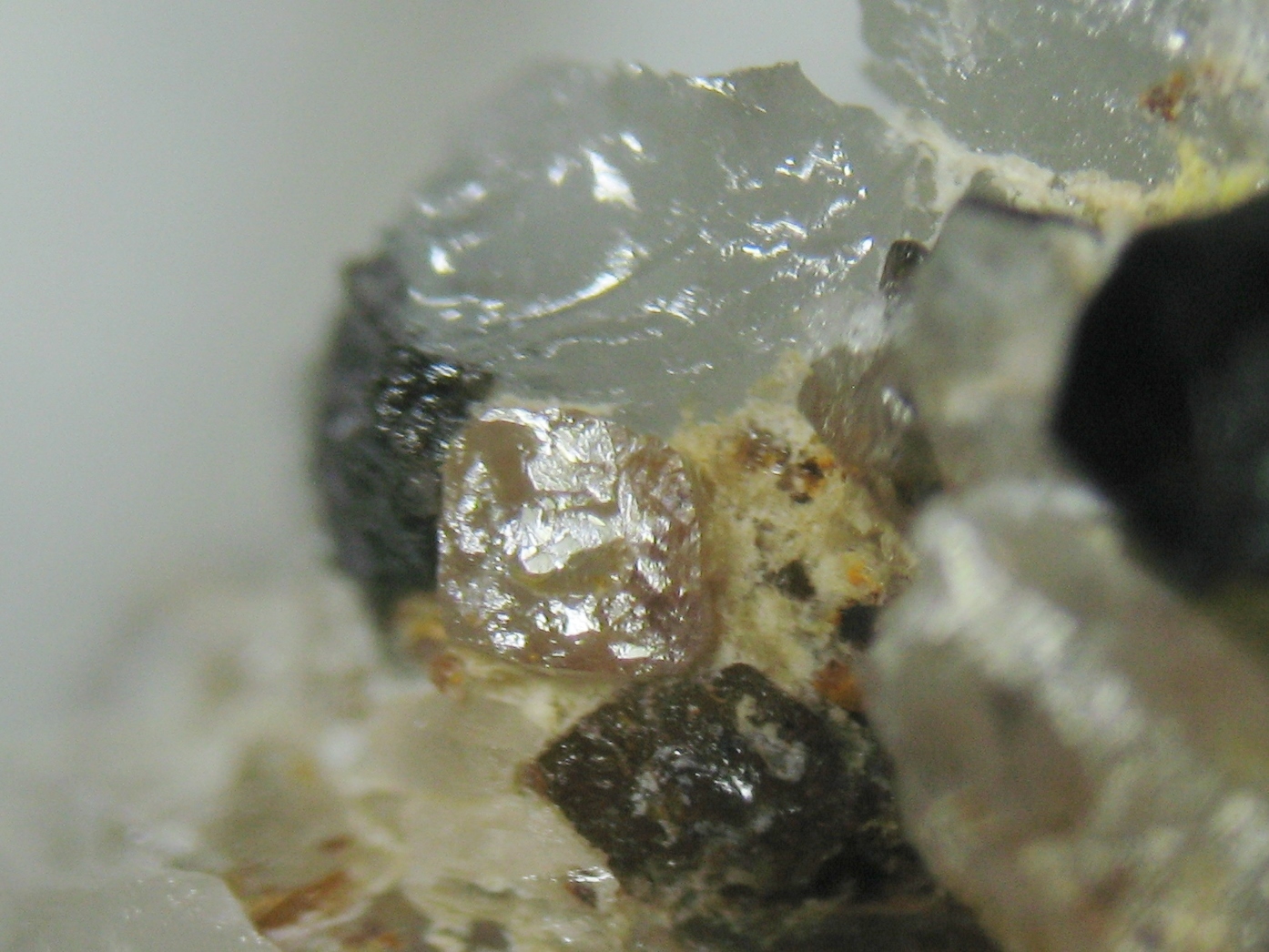
Identity HelpPossible topaz with cassiterite from Trevaunance mine, Cornwall, UK

19th Jan 2016 14:10 UTCJason Evans

19th Jan 2016 15:26 UTCDale Foster Manager
Good crystals are rare though.
19th Jan 2016 18:49 UTCJason Evans
Hopefully I will have another collecting trip in Cornwall this year, if I can I am going to spend more time at Trevaunance as I found the best specimens here in the short amount of time we were there,
Do you happen to know when Trevaunance mine was closed? I read somewhere that the Polberro consols mines closed in 1941 and I think Trevaunance was one of those mines so maybe I already know the answer.
Also i noticed there is a mine called seal hole mine, the mindat location marker looks very close to the dumps where we were collecting, nearer then the marker for Trevaunance mine, are these markers not that accurate or is it possible that the tips were from Trevaunance and seal hole mine?
20th Jan 2016 07:44 UTCDale Foster Manager
-------------------------------------------------------
Do you happen to know when Trevaunance mine was closed? I read somewhere that the Polberro Consols mines closed in 1941 and I think Trevaunance was one of those mines so maybe I already know the answer. Also i noticed there is a mine called Seal Hole mine, the mindat location marker looks very close to the dumps where we were collecting, nearer then the marker for Trevaunance mine, are these markers not that accurate or is it possible that the tips were from Trevaunance and Seal Hole mine?
Hi Jason,
The Trevaunance Mine is part of what became a group of mine known as Polberro Mines and St Agnes Consols. As with many Cornish Mines, they can be a fun job to sort into any semblance of sense.
As to the marker for Trevaunance - no it isn't that accurate, so I wouldn't rely on it totally. As it is showing currently it is too far to the south. I have edited the OS grid reference to lie as close to the location of Engine Shaft as possible as this lies as near as dammit to the centre of the Trevaunance sett. Regarding the Seal Hole marker, again I wouldn't use it as a definitive location tool. If you look on the St Agnes Consols page, have a good look at the 1870 map extract I have uploaded. This is about as clear as it gets as to where the individual mines of the group are located.
In terms of date of closure, the mines in this group largely finished prior to 1890.
The closure date you refer to relates to an attempt to find the Wheal Kitty lode in depth by accessing through Turnavore Shaft and sinking it to a greater depth to intersect the lode. This working started in 1937 and although they cut the West Kitty lode at 730 feet, they didn't find the Wheal Kitty Lode by the time they had gotten to the 1020 foot level. They did pass through a zone of Cassiterite bearing veinlets at between 900 and 1000 feet. Ironically the earlier re-working of Wheal Kitty discovered a signifcant ore shoot by pursuing a similar series of veinlets, so the possibility exists that there is a potential deeper ore body that is yet to be discovered. The second world war caused financial difficulties for the company undertaking the work and it had to be abandoned, hence the 1941 closure date. Incidentally the West Kitty lode assayed values of up to 400 pounds of tin to the ton, but was too patchy to be economic.

20th Jan 2016 19:36 UTCJason Evans
Did mines ever share tips?
21st Jan 2016 08:27 UTCDale Foster Manager
I am not aware of specific tip 'sharing' although with so many small mines forming a larger group with close proximity of shafts in a relatively small area there is possibility of a bit of mixing of waste as tips expanded with use.
Given they all worked various parts of the same group of lodes, unless you can untangle the various shaft names and identify them on the ground you would not be able to draw a greater distinction on the material.
Over time reconciling the old maps to the modern, I have managed to sort out some of the tangle to my own satisfaction.


Mindat.org is an outreach project of the Hudson Institute of Mineralogy, a 501(c)(3) not-for-profit organization.
Copyright © mindat.org and the Hudson Institute of Mineralogy 1993-2024, except where stated. Most political location boundaries are © OpenStreetMap contributors. Mindat.org relies on the contributions of thousands of members and supporters. Founded in 2000 by Jolyon Ralph.
Privacy Policy - Terms & Conditions - Contact Us / DMCA issues - Report a bug/vulnerability Current server date and time: April 25, 2024 18:51:14