Log InRegister
Quick Links : The Mindat ManualThe Rock H. Currier Digital LibraryMindat Newsletter [Free Download]
Home PageAbout MindatThe Mindat ManualHistory of MindatCopyright StatusWho We AreContact UsAdvertise on Mindat
Donate to MindatCorporate SponsorshipSponsor a PageSponsored PagesMindat AdvertisersAdvertise on Mindat
Learning CenterWhat is a mineral?The most common minerals on earthInformation for EducatorsMindat ArticlesThe ElementsThe Rock H. Currier Digital LibraryGeologic Time
Minerals by PropertiesMinerals by ChemistryAdvanced Locality SearchRandom MineralRandom LocalitySearch by minIDLocalities Near MeSearch ArticlesSearch GlossaryMore Search Options
Search For:
Mineral Name:
Locality Name:
Keyword(s):
 
The Mindat ManualAdd a New PhotoRate PhotosLocality Edit ReportCoordinate Completion ReportAdd Glossary Item
Mining CompaniesStatisticsUsersMineral MuseumsClubs & OrganizationsMineral Shows & EventsThe Mindat DirectoryDevice SettingsThe Mineral Quiz
Photo SearchPhoto GalleriesSearch by ColorNew Photos TodayNew Photos YesterdayMembers' Photo GalleriesPast Photo of the Day GalleryPhotography

Kim Macdonald's Photo Gallery

Ngatamariki Power Station

07962110015270021754582.jpg
Ngatamariki thermal area, Wairakei, Taupo District, Waikato Region, New Zealand

At least from above, one of the most colourful power stations in the world, probably merely a sunlit optical illusion. Said to be the largest single binary power station in the world. Accesses the Ngatamariki geothermal field. Google Earth image.
Photo ID: 891454     Uploaded by: Kim Macdonald   Upload date: 2018-05-22   View Count: 154    Status: Public galleries    Type: Photo - 1543×925 (1.4 Mpix)

Clark and Firth Battery Site

08261070015236946547867.jpg
Waiorongomai, Matamata-Piako District, Waikato Region, New Zealand

The concrete structure is for rock crushing for a local council quarry which operated in the 1920's. The crusher closed in 1927, having processed quartz rock. The structure had been built on the Clark and Firth battery site which closed in 1912.
Photo ID: 884958     Uploaded by: Kim Macdonald   Upload date: 2018-04-14   View Count: 178    Status: Public galleries    Type: Photo - 4928×3264 (16.1 Mpix)

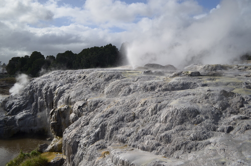
Craters of the Moon (from a distance)

01824460015219105199176.jpg
Wairakei geothermal area, Wairakei, Taupo District, Waikato Region, New Zealand

An overview of the Craters of the Moon site. Geothermal activity started here in 1958, due to a nearby geothermal power station being established, and effecting the underground water dynamics. It contains hydrothermal eruption craters, fumaroles, and minor mud pools, but not the geysers, colourful sinter deposits, and other star attractions of some other geothermal fields in the region. The picture also shows the unique vegetation found in these geothermal areas, that can cope with the extreme conditions.
Photo ID: 881313     Uploaded by: Kim Macdonald   Upload date: 2018-03-24   View Count: 157    Status: Public galleries    Type: Photo - 4928×3264 (16.1 Mpix)

Potahu Geyser

07995980015219106136649.jpg
Te Puia, Rotorua District, Bay of Plenty Region, New Zealand

This is not taken when it erupts, which is apparently 30 metres high. At other times it hisses and spits. Reliably informed by the entrance staff while they were taking my money, the geyser erupts numerous times per day, I stood next to it for two hours, while the geyser acted like a diva and refused to perform. A watched pot never boils as Benjamin Franklin said.
Photo ID: 881312     Uploaded by: Kim Macdonald   Upload date: 2018-03-24   View Count: 124    Status: Public galleries    Type: Photo - 4928×3264 (16.1 Mpix)

Lake Rotorua

00911440015215662035449.jpg
Lake Rotorua Area, Rotorua District, Bay of Plenty Region, New Zealand

Around 200 000 years ago major volcanic eruptions caused the ground to collapse, forming a 16 kilometre wide caldera, now partly filled by Lake Rotorua. In the background is Mokoia Island, a rhyolite dome, formed later by slowly oozing lava in the caldera. In the foreground is part of the Ohinemutu Maori village, in particular the meeting house and 1914 St Faiths Church. Both are beautifully decorated with Moari carvings. This Maori village is occupied by the Ngati Whakaue tribe, and is the original settlement before all the tourists arrived. It is a 10 minute walk from downtown Rotorua. The village can be walked around for free, but please show respect, and be unobtrusive. Surrounding the village are hot springs and steam vents as can partly be seen in the photograph.
Photo ID: 880562     Uploaded by: Kim Macdonald   Upload date: 2018-03-20   View Count: 117    Status: Public galleries    Type: Photo - 4928×3264 (16.1 Mpix)

Sugar Loaf Islands

05768000015209453613733.jpg
Sugar Loaf Islands, New Plymouth, New Plymouth District, Taranaki Region, New Zealand

On a cold blustery winters day. Type locality for taranakite, a phosphate mineral formed from the interaction of clays and bird guano in damp conditions. The island to the right is Motumahanga, then to the left Moturoa, and the pinnacle on the mainland is Paritutu. Also seen is the power station chimney at the New Plymouth port. There are three other islands in the group not part of the photograph.
Photo ID: 879297     Uploaded by: Kim Macdonald   Upload date: 2018-03-13   View Count: 162    Status: Public galleries    Type: Photo - 4928×3264 (16.1 Mpix)

Gemstone Beach Gold Placer Deposits

07124500015192291212890.jpg
Gemstone Beach, Orepuki, Southland District, Southland Region, New Zealand

Gold and other treasures may at times be found along the beach which is open to the public. Maybe stay out of the mining claim though right next to the car park.
Photo ID: 874652     Uploaded by: Kim Macdonald   Upload date: 2018-02-21   View Count: 261    Status: Public galleries    Type: Photo - 4928×3264 (16.1 Mpix)

Gemstone Beach

03731390015192291242176.jpg
Gemstone Beach, Orepuki, Southland District, Southland Region, New Zealand

Photo ID: 874650     Uploaded by: Kim Macdonald   Upload date: 2018-02-21   View Count: 193    Status: Public galleries    Type: Photo - 4928×3264 (16.1 Mpix)

Queenstown

05753400015161818632533.jpg
Queenstown, Queenstown-Lakes District, Otago Region, New Zealand

Photo ID: 865799     Uploaded by: Kim Macdonald   Upload date: 2018-01-17   View Count: 113    Status: Public galleries    Type: Photo - 4928×3264 (16.1 Mpix)

Arrowtown Chinese Settlement

09288680015161446502662.jpg
Arrowtown, Queenstown-Lakes District, Otago Region, New Zealand

The Otago Provincial Government had encouraged Chinese miners to emigrate, after several fields became deserted after the 1862-1863 gold rushes. Miners had left for the newly discovered gold fields on the West Coast, which may have not been any better, but the grass is always greener.... Not everyone was happy with large numbers of Chinese arriving on the Otago gold fields. Most were from the Canton area. In some areas they consisted of about half the miners. They often took over abandoned claims from other miners, and many found little gold, or much money to send back to their families in China. A short walk from the main street in Arrowtown, are several stone cottages, hut ruins, old garden walls etc from the Chinese settlement here, with interpretative panels.
Photo ID: 865791     Uploaded by: Kim Macdonald   Upload date: 2018-01-16   View Count: 117    Status: Public galleries    Type: Photo - 4928×3264 (16.1 Mpix)
Page 1 of 165 (1 to 10 of 1643 total)
1 2 3 4 5 6 7 8 9 10 11 12 13 14 15 16 17 ...
 
Mineral and/or Locality  
Mindat Discussions Facebook Logo Instagram Logo Discord Logo
Mindat.org is an outreach project of the Hudson Institute of Mineralogy, a 501(c)(3) not-for-profit organization.
Copyright © mindat.org and the Hudson Institute of Mineralogy 1993-2024, except where stated. Most political location boundaries are © OpenStreetMap contributors. Mindat.org relies on the contributions of thousands of members and supporters. Founded in 2000 by Jolyon Ralph.
Privacy Policy - Terms & Conditions - Contact Us / DMCA issues - Report a bug/vulnerability Current server date and time: April 25, 2024 23:34:27
Go to top of page