Log InRegister
Quick Links : The Mindat ManualThe Rock H. Currier Digital LibraryMindat Newsletter [Free Download]
Home PageAbout MindatThe Mindat ManualHistory of MindatCopyright StatusWho We AreContact UsAdvertise on Mindat
Donate to MindatCorporate SponsorshipSponsor a PageSponsored PagesMindat AdvertisersAdvertise on Mindat
Learning CenterWhat is a mineral?The most common minerals on earthInformation for EducatorsMindat ArticlesThe ElementsThe Rock H. Currier Digital LibraryGeologic Time
Minerals by PropertiesMinerals by ChemistryAdvanced Locality SearchRandom MineralRandom LocalitySearch by minIDLocalities Near MeSearch ArticlesSearch GlossaryMore Search Options
Search For:
Mineral Name:
Locality Name:
Keyword(s):
 
The Mindat ManualAdd a New PhotoRate PhotosLocality Edit ReportCoordinate Completion ReportAdd Glossary Item
Mining CompaniesStatisticsUsersMineral MuseumsClubs & OrganizationsMineral Shows & EventsThe Mindat DirectoryDevice SettingsThe Mineral Quiz
Photo SearchPhoto GalleriesSearch by ColorNew Photos TodayNew Photos YesterdayMembers' Photo GalleriesPast Photo of the Day GalleryPhotography

Aaron Wiltsey's Photo Gallery

7N9-A27Stilbite Subgroup M6-7[Al8-9Si27-28O72]·nH2O , Apophyllite Group AB4[Si8O22]X · 8H2O , Quartz SiO2

01925720014947030738967.jpg
Wind Creek Quarry, Buell, Polk County, Oregon, USA

Dimensions: 15 inches x 10 inches x 10 inches

Clusters of clear pyramid-tipped apophyllite and sharp spear-teeth of quartz growing on peach-colored stilbite sheaves decorate the interior of this small cavity. I managed to save 90% of it by prying loose the 15"x10"x10" chunk of basalt it formed in.
Copyright: © Aaron Wiltsey      Photo ID: 122225     Uploaded by: Aaron Wiltsey   Upload date: 2007-10-03   View Count: 547    Status: Public galleries    Type: Photo - 800×533 (0.4 Mpix)

8G4-H6LNatrolite Na2Al2Si3O10·2H2O

04949120014947029683081.jpg
Wren, Benton County, Oregon, USA

Natural pocket of acicular natrolite growing in pillow basalt at the Wren quarry in Benton County, Oregon, USA. Pocket is approximately 10 inches (25.5 cm) across. My apologies for the dirt and rock crumbs, but I was clinging to a crumbly rock wall 20 feet up with an expensive digicam in hand. ;) Photo courtesy of Aaron Wiltsey.
Photo ID: 36557     Uploaded by: Aaron Wiltsey   Upload date: 2005-08-22   View Count: 1063    Status: Public galleries    Type: Photo - 800×588 (0.5 Mpix)

View of the quarry from the end of the road

05573300014947030739189.jpg
Trashed Quarry, Price Creek area, Kings Valley, Benton County, Oregon, USA

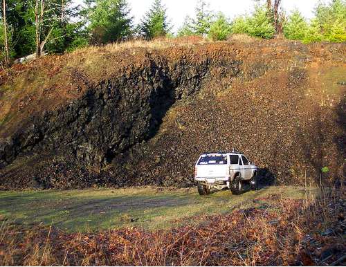
Photo by A. Wiltsey, 1/2006
Copyright: © A. Wiltsey, 2006      Photo ID: 125730     Uploaded by: Aaron Wiltsey   View Count: 667    Status: Public galleries    Type: Photo - 800×617 (0.5 Mpix)

Wren quarry as seen from above, right wall.

06624750014947030734058.jpg
Wren, Benton County, Oregon, USA

View of the Wren quarry from above, right side at rear of the quarry. Main entrance road is at the top left. Private property, actively being quarried(obviously). Always wear boots and a hard hat in a quarry such as this.
Copyright: © Aaron Wiltsey      Photo ID: 124898     Uploaded by: Aaron Wiltsey   View Count: 508    Status: Public galleries    Type: Photo - 800×533 (0.4 Mpix)

Quarry at Wren, Oregon as seen from above.

03779670014947030741120.jpg
Wren, Benton County, Oregon, USA

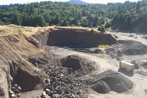
Overview of the large quarry at Wren, Oregon, USA. Great locality for collecting natrolite, calcite crystals and many other types of zeolites and minerals. Quarry is on private property, collecting is not openly encouraged. Always wear a hard hat and boots in a quarry such as this one.
Photo ID: 124897     Uploaded by: Aaron Wiltsey   View Count: 616    Status: Public galleries    Type: Photo - 750×500 (0.4 Mpix)

Main osumilite collecting site at base of scree slope.

04383650014946698674500.jpg
Obsidian Cliffs, North Sister Mountain, McKenzie Pass, Lane County, Oregon, USA

Rare Osumilite locality in Oregon, USA. One of a dozen or so known localities in the world. Taken by Aaron Wiltsey on 8/17/05. Osumilite crystals are found in scoria boulders at the base of the scree slope. This is a designated wilderness area with limited access to hikers, so collecting is not legal here.
Photo ID: 124679     Uploaded by: Aaron Wiltsey   View Count: 1590    Status: Public galleries    Type: Photo - 800×600 (0.5 Mpix)
 
Mineral and/or Locality  
Mindat Discussions Facebook Logo Instagram Logo Discord Logo
Mindat.org is an outreach project of the Hudson Institute of Mineralogy, a 501(c)(3) not-for-profit organization.
Copyright © mindat.org and the Hudson Institute of Mineralogy 1993-2024, except where stated. Most political location boundaries are © OpenStreetMap contributors. Mindat.org relies on the contributions of thousands of members and supporters. Founded in 2000 by Jolyon Ralph.
Privacy Policy - Terms & Conditions - Contact Us / DMCA issues - Report a bug/vulnerability Current server date and time: April 19, 2024 06:08:16
Go to top of page