Black Rock Mine, Deep Creek Area, Northport Mining District, Stevens County, Washington, USAi
| Regional Level Types | |
|---|---|
| Black Rock Mine | Mine |
| Deep Creek Area | Area |
| Northport Mining District | Mining District |
| Stevens County | County |
| Washington | State |
| USA | Country |
This page is currently not sponsored. Click here to sponsor this page.


Latitude & Longitude (WGS84):
48° 52' 12'' North , 117° 42' 21'' West
Latitude & Longitude (decimal):
Type:
Köppen climate type:
Nearest Settlements:
| Place | Population | Distance |
|---|---|---|
| Northport | 288 (2017) | 7.5km |
| Metaline | 172 (2017) | 23.2km |
| Metaline Falls | 241 (2017) | 24.4km |
| Rossland | 3,619 (2008) | 24.7km |
| Trail | 9,707 (2018) | 25.5km |
Nearest Clubs:
Local clubs are the best way to get access to collecting localities
Local clubs are the best way to get access to collecting localities
| Club | Location | Distance |
|---|---|---|
| Selkirk Rock & Mineral Club | Trail, British Columbia | 25km |
| Panorama Gem & Mineral Club | Arden, Washington | 47km |
Mindat Locality ID:
19314
Long-form identifier:
mindat:1:2:19314:5
GUID (UUID V4):
8587375a-cc65-4ce5-b7c3-6aff5f1816e1
Other/historical names associated with this locality:
Washington Black Rock Mine; Gorien Mine; Gorien Zinc Mine
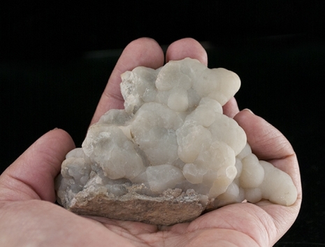
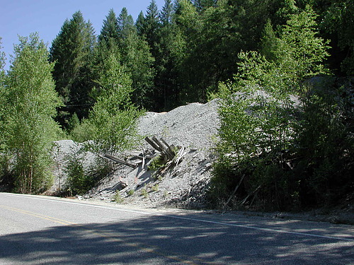
A zinc mine along Deep Creek. The deposit occurs along a fault in the middle dolomite unit of the Metaline Formation (Mills). Development consisted of an adit with stopes down to 750' below the adit level along a series of winzes. Production was reported by Mills (1977) to be 140,000 lb of lead, 7,900,000 lb of zinc, and 377 oz of silver.
Select Mineral List Type
Standard Detailed Gallery Strunz Chemical ElementsCommodity List
This is a list of exploitable or exploited mineral commodities recorded at this locality.Mineral List
4 valid minerals.
Detailed Mineral List:
| ⓘ Dolomite Formula: CaMg(CO3)2 |
| ⓘ Galena Formula: PbS |
| ⓘ Smithsonite Formula: ZnCO3 |
| ⓘ Sphalerite Formula: ZnS |
Gallery:

List of minerals arranged by Strunz 10th Edition classification
| Group 2 - Sulphides and Sulfosalts | |||
|---|---|---|---|
| ⓘ | Sphalerite | 2.CB.05a | ZnS |
| ⓘ | Galena | 2.CD.10 | PbS |
| Group 5 - Nitrates and Carbonates | |||
| ⓘ | Smithsonite | 5.AB.05 | ZnCO3 |
| ⓘ | Dolomite | 5.AB.10 | CaMg(CO3)2 |
List of minerals for each chemical element
| C | Carbon | |
|---|---|---|
| C | ⓘ Dolomite | CaMg(CO3)2 |
| C | ⓘ Smithsonite | ZnCO3 |
| O | Oxygen | |
| O | ⓘ Dolomite | CaMg(CO3)2 |
| O | ⓘ Smithsonite | ZnCO3 |
| Mg | Magnesium | |
| Mg | ⓘ Dolomite | CaMg(CO3)2 |
| S | Sulfur | |
| S | ⓘ Galena | PbS |
| S | ⓘ Sphalerite | ZnS |
| Ca | Calcium | |
| Ca | ⓘ Dolomite | CaMg(CO3)2 |
| Zn | Zinc | |
| Zn | ⓘ Smithsonite | ZnCO3 |
| Zn | ⓘ Sphalerite | ZnS |
| Pb | Lead | |
| Pb | ⓘ Galena | PbS |
Other Regions, Features and Areas containing this locality
North America
- Columbia MountainsMountain Range
North America PlateTectonic Plate
- Antler Foreland BasinBasin
- Pend Oreille DomainDomain
This page contains all mineral locality references listed on mindat.org. This does not claim to be a complete list. If you know of more minerals from this site, please register so you can add to our database. This locality information is for reference purposes only. You should never attempt to
visit any sites listed in mindat.org without first ensuring that you have the permission of the land and/or mineral rights holders
for access and that you are aware of all safety precautions necessary.
References


Black Rock Mine, Deep Creek Area, Northport Mining District, Stevens County, Washington, USA