South Wollo Zone, Amhara Region, Ethiopiai
| Regional Level Types | |
|---|---|
| South Wollo Zone | Zone |
| Amhara Region | Region |
| Ethiopia | Country |
This page is currently not sponsored. Click here to sponsor this page.


Type:
Mindat Locality ID:
210582
Long-form identifier:
mindat:1:2:210582:9
GUID (UUID V4):
e333fa16-7eb7-4dc1-bd43-ed2f9175efa1
Other/historical names associated with this locality:
Welo; Wello
Other Languages:
Amharic:
ደቡብ ወሎ ዞን, አማራ, ኢትዮጵያ
French:
Debub Wollo, Amhara, Éthiopie
Russian:
Южное Уолло, Амхара, Эфиопия
Simplified Chinese:
南沃洛地區, 阿姆哈拉州, 埃塞俄比亚
Cebuano:
South Wollo Zone, Amhara Region, Etiopia
Hebrew:
דרום וולו, אמהרה, אתיופיה
Japanese:
南ウォロ県, アムハラ州, エチオピア
Swedish:
South Wollo Zone, Amhara, Etiopien
Traditional Chinese:
南沃洛地區, 岩哈拉州, 埃塞俄比亞
Zulu:
South Wollo Zone, I-Ithiopia
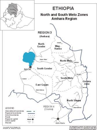
South Wollo (Amharic: ደቡብ ወሎ) is a zone in the Amhara Region of Ethiopia. It acquired its name from the former province of Wollo. South Wollo is bordered on the south by North Shewa and the Oromia Region, on the west by East Gojjam, on the northwest by South Gondar, on the north by North Wollo, on the northeast by Afar Region, and on the east by the Oromia Special Zone and the Argobba special woreda. Its highest point is Mount Tabor in Amhara Sayint, 4247 meter above sea level. Towns in South Wollo include Kombolcha, Hayq, Dessie, Wuchale, Aqesta, SaintAjibar, Degolo and Mekaneselam.
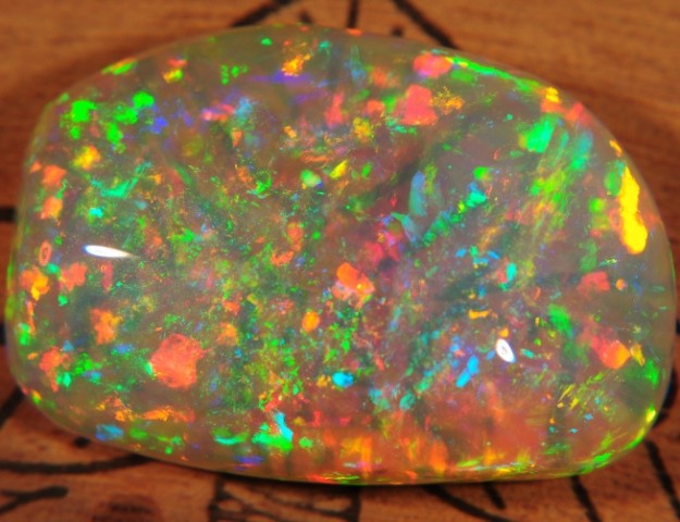
Outstanding precious fire opal occurrences.
The opal forms thin layers in a Tertiary ignimbrite rock, or fills voids in plant fossils within this rock.
The main occurrence is near Tsehay Mewcha.
Select Mineral List Type
Standard Detailed Gallery Strunz Chemical ElementsMineral List
Mineral list contains entries from the region specified including sub-localities1 valid mineral.
Rock Types Recorded
Note: data is currently VERY limited. Please bear with us while we work towards adding this information!
Rock list contains entries from the region specified including sub-localities
Select Rock List Type
Alphabetical List Tree DiagramDetailed Mineral List:
| ⓘ Opal Formula: SiO2 · nH2O Localities: |
| ⓘ Opal var. Precious Opal Formula: SiO2 · nH2O References: |
| ⓘ Opal var. White Opal References: |

List of minerals arranged by Strunz 10th Edition classification
| Group 4 - Oxides and Hydroxides | |||
|---|---|---|---|
| ⓘ | Opal | 4.DA.10 | SiO2 · nH2O |
| ⓘ | var. Precious Opal | 4.DA.10 | SiO2 · nH2O |
| ⓘ | var. White Opal | 4.DA.10 | SiO2 · nH2O |
List of minerals for each chemical element
| H | Hydrogen | |
|---|---|---|
| H | ⓘ Opal | SiO2 · nH2O |
| H | ⓘ Opal var. Precious Opal | SiO2 · nH2O |
| O | Oxygen | |
| O | ⓘ Opal | SiO2 · nH2O |
| O | ⓘ Opal var. Precious Opal | SiO2 · nH2O |
| Si | Silicon | |
| Si | ⓘ Opal | SiO2 · nH2O |
| Si | ⓘ Opal var. Precious Opal | SiO2 · nH2O |
Fossils
This region is too big or complex to display the fossil list, try looking at smaller subregions.Other Databases
| Wikipedia: | https://en.wikipedia.org/wiki/South_Wollo_Zone |
|---|---|
| Wikidata ID: | Q2919962 |
| GeoNames ID: | 7732961 |
Localities in this Region
- Amhara Region
- South Wollo Zone
Other Regions, Features and Areas that Intersect
This page contains all mineral locality references listed on mindat.org. This does not claim to be a complete list. If you know of more minerals from this site, please register so you can add to our database. This locality information is for reference purposes only. You should never attempt to
visit any sites listed in mindat.org without first ensuring that you have the permission of the land and/or mineral rights holders
for access and that you are aware of all safety precautions necessary.
References


South Wollo Zone, Amhara Region, Ethiopia