Puerto de la Cruz Verde Quarries, Zarzalejo, Community of Madrid, Spaini
| Regional Level Types | |
|---|---|
| Puerto de la Cruz Verde Quarries | Group of Quarries |
| Zarzalejo | Village |
| Community of Madrid | Autonomous Community |
| Spain | Country |
This page is currently not sponsored. Click here to sponsor this page.


Latitude & Longitude (WGS84):
40° 33' 19'' North , 4° 11' 47'' West
Latitude & Longitude (decimal):
Locality type:
Group of Quarries
Köppen climate type:
Nearest Settlements:
| Place | Population | Distance |
|---|---|---|
| Zarzalejo | 1,327 (2012) | 1.5km |
| San Lorenzo de El Escorial | 17,889 (2012) | 5.8km |
| El Escorial | 14,979 (2010) | 6.5km |
| Santa María de la Alameda | 992 (2011) | 6.8km |
| Robledo de Chavela | 3,239 (2012) | 6.9km |
Name(s) in local language(s):
Canteras del Puerto de la Cruz Verde, Zarzalejo, Madrid, España
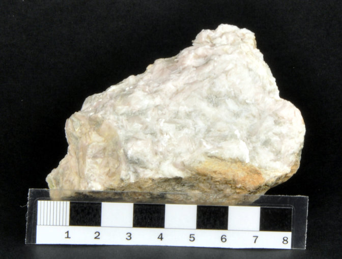
Magnesite outcrop originated by hydrothermal alteration of dolomite rocks including chrysotile, talc, serpentine and pyrite.
Quarry located in an old magnesite mining area, that were exploited in underground galleries, in which some remains of quarries and surface installations can be seen. The mineralization covers a wide area that covers three adjoining municipalities: San Lorenzo del Escorial, Zarzalejo and Santa María de la Alhameda. The area acquired interest at the beginning of the 20th century. Although it is currently inactive, up to 30 tons per day were exploited in the 1970s.
Cantera situada en el área de unas antiguas minas de magnesita que fueron explotadas en galerías subterráneas, de las que pueden verse algunos restos de canteras e instalaciones en superficie. La mineralización abarca un amplia área que cubre tres municipio colindantes: San Lorenzo del Escorial, Zarzalejo y Santa María de la Alhameda. La zona adquirió interés a comienzo del siglo XX. Aunque en la actualidad se encuentra inactiva, se llegaron a explotar hasta 30 toneladas diarias en los años 1970´s.
Select Mineral List Type
Standard Detailed Gallery Strunz Chemical ElementsDetailed Mineral List:
| ⓘ Chrysotile Formula: Mg3(Si2O5)(OH)4 Reference: Geominero Museum of Madrid collection |
| ⓘ Magnesite Formula: MgCO3 Reference: Geominero Museum of Madrid collection |
| ⓘ Pyrite Formula: FeS2 Reference: Geominero Museum of Madrid collection |
| ⓘ Quartz Formula: SiO2 Reference: Fernando Gascón collection |
| ⓘ 'Serpentine Subgroup' Formula: D3[Si2O5](OH)4 Reference: Geominero Museum of Madrid collection |
| ⓘ Talc Formula: Mg3Si4O10(OH)2 Reference: Geominero Museum of Madrid collection |

Gallery:
List of minerals arranged by Strunz 10th Edition classification
| Group 2 - Sulphides and Sulfosalts | |||
|---|---|---|---|
| ⓘ | Pyrite | 2.EB.05a | FeS2 |
| Group 4 - Oxides and Hydroxides | |||
| ⓘ | Quartz | 4.DA.05 | SiO2 |
| Group 5 - Nitrates and Carbonates | |||
| ⓘ | Magnesite | 5.AB.05 | MgCO3 |
| Group 9 - Silicates | |||
| ⓘ | Chrysotile | 9.ED.15 | Mg3(Si2O5)(OH)4 |
| ⓘ | Talc | 9.EC.05 | Mg3Si4O10(OH)2 |
| Unclassified Minerals, Rocks, etc. | |||
| ⓘ | 'Serpentine Subgroup' | - | D3[Si2O5](OH)4 |
List of minerals for each chemical element
| H | Hydrogen | |
|---|---|---|
| H | ⓘ Talc | Mg3Si4O10(OH)2 |
| H | ⓘ Serpentine Subgroup | D3[Si2O5](OH)4 |
| H | ⓘ Chrysotile | Mg3(Si2O5)(OH)4 |
| C | Carbon | |
| C | ⓘ Magnesite | MgCO3 |
| O | Oxygen | |
| O | ⓘ Magnesite | MgCO3 |
| O | ⓘ Talc | Mg3Si4O10(OH)2 |
| O | ⓘ Serpentine Subgroup | D3[Si2O5](OH)4 |
| O | ⓘ Chrysotile | Mg3(Si2O5)(OH)4 |
| O | ⓘ Quartz | SiO2 |
| Mg | Magnesium | |
| Mg | ⓘ Magnesite | MgCO3 |
| Mg | ⓘ Talc | Mg3Si4O10(OH)2 |
| Mg | ⓘ Chrysotile | Mg3(Si2O5)(OH)4 |
| Si | Silicon | |
| Si | ⓘ Talc | Mg3Si4O10(OH)2 |
| Si | ⓘ Serpentine Subgroup | D3[Si2O5](OH)4 |
| Si | ⓘ Chrysotile | Mg3(Si2O5)(OH)4 |
| Si | ⓘ Quartz | SiO2 |
| S | Sulfur | |
| S | ⓘ Pyrite | FeS2 |
| Fe | Iron | |
| Fe | ⓘ Pyrite | FeS2 |
References
Sort by
Year (asc) Year (desc) Author (A-Z) Author (Z-A)Jiménez Martínez, R., González Laguna, R., Lozano Fernández, R.P., Paradas Herrero, Á., Baeza Chico, E., Torres Matilla, M.J. y Cabrera Andonaegui, B. (2013). Colección de Minerales de las Comunidades y Ciudades Autónomas del Museo Geominero: Catálogo de la Comunidad de Madrid. Cuadernos del Museo Geominero, 16, publicación en CD-ROM.
Mazadiego Martínez, L.F., O. Puche Riart, O., Jordá Bordehore, L. (2003). Las Minas de Magnesita del Puerto de La Cruz Verde (Madrid). En "Patrimonio Geológico y Minero y Desarroyo Regional", pag. 267-280, I.G.M.E., Madrid.
External Links
http://www.foro-minerales.com/forum/viewtopic.php?p=103885 (Madrid minerals catalog of Geominero Museum, in Spanish language)
http://www.foro-minerales.com/forum/viewtopic.php?p=105217 (discussion about the locality, in Spanish language)
http://oa.upm.es/10813/2/cruz_verde2.pdf (link to : Mazadiego Martínez, L.F., O. Puche Riart, O., Jordá Bordehore, L. (2003). Las Minas de Magnesita del Puerto de La Cruz Verde (Madrid). En: Patrimonio Geológico y Minero y Desarroyo Regional, pag. 267-280, I.G.M.E., Madrid.)
http://speleominas.blogspot.com/2011/10/mina-de-magnesita-subterranea-del.html (Link to a blog with interesting historical photographs of the exploitation of magnesite in underground galleries)
Other Regions, Features and Areas containing this locality
This page contains all mineral locality references listed on mindat.org. This does not claim to be a complete list. If you know of more minerals from this site, please register so you can add to our database. This locality information is for reference purposes only. You should never attempt to
visit any sites listed in mindat.org without first ensuring that you have the permission of the land and/or mineral rights holders
for access and that you are aware of all safety precautions necessary.


Puerto de la Cruz Verde Quarries, Zarzalejo, Community of Madrid, Spain