Chartreuzenberg, Holsbeek, Flemish Brabant, Flanders, Belgiumi
| Regional Level Types | |
|---|---|
| Chartreuzenberg | Hill |
| Holsbeek | Municipality |
| Flemish Brabant | Province |
| Flanders | Region |
| Belgium | Country |
This page is currently not sponsored. Click here to sponsor this page.


Latitude & Longitude (WGS84):
50° 54' 36'' North , 4° 45' 23'' East
Latitude & Longitude (decimal):
Type:
Köppen climate type:
Nearest Clubs:
Local clubs are the best way to get access to collecting localities
Local clubs are the best way to get access to collecting localities
| Club | Location | Distance |
|---|---|---|
| MKA, Mineralogische Kring Antwerpen | Edegem, Antwerp | 37km |
| ACAM | 2170 Merksem, Antwerp | 43km |
Mindat Locality ID:
262605
Long-form identifier:
mindat:1:2:262605:8
GUID (UUID V4):
127f70b4-0a62-4bab-afff-d614507d379a
Name(s) in local language(s):
Chartreuzenberg, Holsbeek, Provincie Vlaams Brabant, België
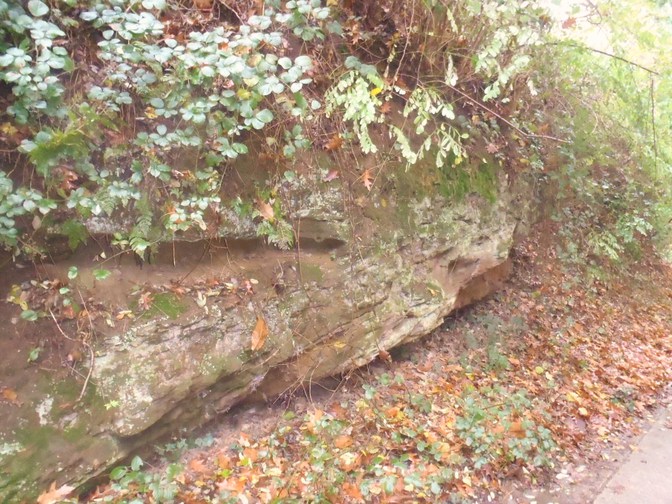
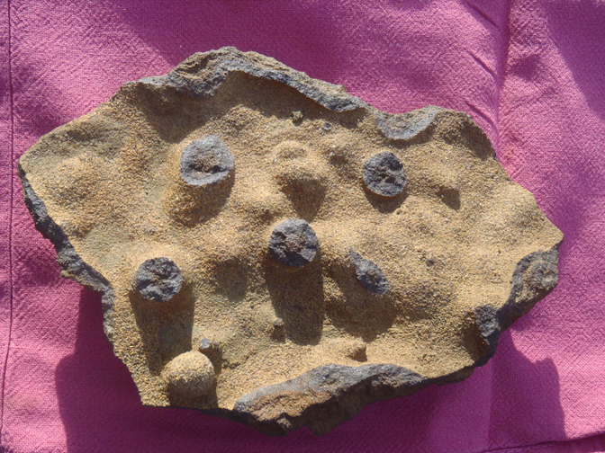
A hill consisting of "iron sandstone": marine sands with glauconite that were oxidized.
The produced 'limonite' cemented the sand into 'iron sandstone' with a particular brown color.
The limonite layers were exploited for smelting iron in low furnaces, from the Celtic times till the Middle Ages: slags of this production are still found on the fields.
Select Mineral List Type
Standard Detailed Gallery Strunz Chemical ElementsDetailed Mineral List:
| ⓘ 'Glauconite' Formula: K0.60-0.85(Fe3+,Mg,Al)2(Si,Al)4O10](OH)2 |
| ⓘ 'Limonite' |
Gallery:

List of minerals arranged by Strunz 10th Edition classification
| Unclassified | |||
|---|---|---|---|
| ⓘ | 'Glauconite' | - | K0.60-0.85(Fe3+,Mg,Al)2(Si,Al)4O10](OH)2 |
| ⓘ | 'Limonite' | - | |
List of minerals for each chemical element
| H | Hydrogen | |
|---|---|---|
| H | ⓘ Glauconite | K0.60-0.85(Fe3+,Mg,Al)2(Si,Al)4O10](OH)2 |
| O | Oxygen | |
| O | ⓘ Glauconite | K0.60-0.85(Fe3+,Mg,Al)2(Si,Al)4O10](OH)2 |
| Mg | Magnesium | |
| Mg | ⓘ Glauconite | K0.60-0.85(Fe3+,Mg,Al)2(Si,Al)4O10](OH)2 |
| Al | Aluminium | |
| Al | ⓘ Glauconite | K0.60-0.85(Fe3+,Mg,Al)2(Si,Al)4O10](OH)2 |
| Si | Silicon | |
| Si | ⓘ Glauconite | K0.60-0.85(Fe3+,Mg,Al)2(Si,Al)4O10](OH)2 |
| K | Potassium | |
| K | ⓘ Glauconite | K0.60-0.85(Fe3+,Mg,Al)2(Si,Al)4O10](OH)2 |
| Fe | Iron | |
| Fe | ⓘ Glauconite | K0.60-0.85(Fe3+,Mg,Al)2(Si,Al)4O10](OH)2 |
Other Regions, Features and Areas containing this locality
Eurasian PlateTectonic Plate
EuropeContinent
This page contains all mineral locality references listed on mindat.org. This does not claim to be a complete list. If you know of more minerals from this site, please register so you can add to our database. This locality information is for reference purposes only. You should never attempt to
visit any sites listed in mindat.org without first ensuring that you have the permission of the land and/or mineral rights holders
for access and that you are aware of all safety precautions necessary.
References


Chartreuzenberg, Holsbeek, Flemish Brabant, Flanders, Belgium