Unnamed gully, Flateyjardalur, Þingeyjarsveit, Northeastern Region, Icelandi
| Regional Level Types | |
|---|---|
| Unnamed gully | Gully |
| Flateyjardalur | Valley |
| Þingeyjarsveit | Municipality |
| Northeastern Region | Region |
| Iceland | Country |
This page is currently not sponsored. Click here to sponsor this page.
Latitude & Longitude (WGS84):
66° 3' 11'' North , 17° 53' 8'' West
Latitude & Longitude (decimal):
Type:
Köppen climate type:
Nearest Settlements:
| Place | Population | Distance |
|---|---|---|
| Grenivík | 278 (2016) | 17.3km |
| Hrísey | 171 (2016) | 23.7km |
| Litli-Árskógssandur | 112 (2016) | 24.5km |
| Svalbarðseyri | 271 (2016) | 35.8km |
| Akureyri | 17,693 (2016) | 42.1km |
Mindat Locality ID:
263226
Long-form identifier:
mindat:1:2:263226:4
GUID (UUID V4):
c7f0eddb-176c-4ee9-afa4-dbfb87024d79
Name(s) in local language(s):
Unnamed gully, Flateyjardalur, Norðurland eystra, Ísland
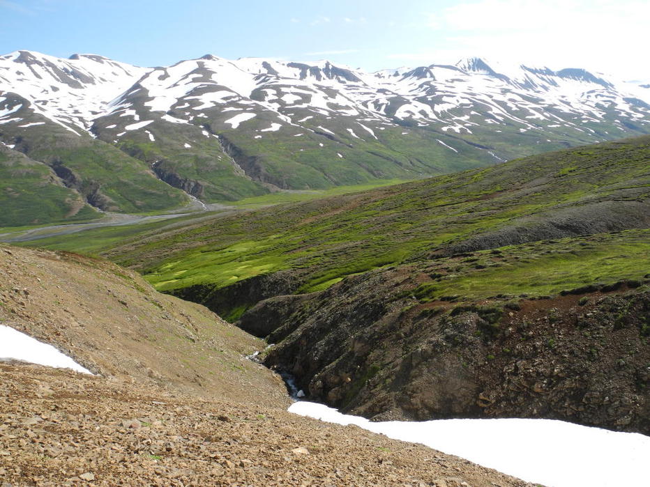
This locality is a nameless creek, which branches off from Flateyjardalur about 1 km north of the ruins of the farm Saurbrúarkot and can be reached via F899. There are two creeks close together. Follow the left one up to the upper part where you find layers with zeolites.
Select Mineral List Type
Standard Detailed Gallery Strunz Chemical ElementsDetailed Mineral List:
| ⓘ Analcime Formula: Na(AlSi2O6) · H2O Reference: Personally collected by Günter Frenz |
| ⓘ 'Heulandite Subgroup' Reference: Personally collected by Günter Frenz |
| ⓘ Laumontite Formula: CaAl2Si4O12 · 4H2O Reference: Personally collected by Günter Frenz |
| ⓘ Mesolite Formula: Na2Ca2Si9Al6O30 · 8H2O Reference: Personally collected by Günter Frenz |
| ⓘ Quartz Formula: SiO2 Reference: Personally collected by Günter Frenz |
| ⓘ 'Stilbite Subgroup' Formula: M6-7[Al8-9Si27-28O72] · nH2O Reference: Personally collected by Günter Frenz |
Gallery:
List of minerals arranged by Strunz 10th Edition classification
| Group 4 - Oxides and Hydroxides | |||
|---|---|---|---|
| ⓘ | Quartz | 4.DA.05 | SiO2 |
| Group 9 - Silicates | |||
| ⓘ | Analcime | 9.GB.05 | Na(AlSi2O6) · H2O |
| ⓘ | Laumontite | 9.GB.10 | CaAl2Si4O12 · 4H2O |
| ⓘ | Mesolite | 9.GA.05 | Na2Ca2Si9Al6O30 · 8H2O |
| Unclassified Minerals, Rocks, etc. | |||
| ⓘ | 'Heulandite Subgroup' | - | |
| ⓘ | 'Stilbite Subgroup' | - | M6-7[Al8-9Si27-28O72] · nH2O |
List of minerals for each chemical element
| H | Hydrogen | |
|---|---|---|
| H | ⓘ Analcime | Na(AlSi2O6) · H2O |
| H | ⓘ Laumontite | CaAl2Si4O12 · 4H2O |
| H | ⓘ Mesolite | Na2Ca2Si9Al6O30 · 8H2O |
| H | ⓘ Stilbite Subgroup | M6-7[Al8-9Si27-28O72] · nH2O |
| O | Oxygen | |
| O | ⓘ Analcime | Na(AlSi2O6) · H2O |
| O | ⓘ Laumontite | CaAl2Si4O12 · 4H2O |
| O | ⓘ Mesolite | Na2Ca2Si9Al6O30 · 8H2O |
| O | ⓘ Quartz | SiO2 |
| O | ⓘ Stilbite Subgroup | M6-7[Al8-9Si27-28O72] · nH2O |
| Na | Sodium | |
| Na | ⓘ Analcime | Na(AlSi2O6) · H2O |
| Na | ⓘ Mesolite | Na2Ca2Si9Al6O30 · 8H2O |
| Al | Aluminium | |
| Al | ⓘ Analcime | Na(AlSi2O6) · H2O |
| Al | ⓘ Laumontite | CaAl2Si4O12 · 4H2O |
| Al | ⓘ Mesolite | Na2Ca2Si9Al6O30 · 8H2O |
| Al | ⓘ Stilbite Subgroup | M6-7[Al8-9Si27-28O72] · nH2O |
| Si | Silicon | |
| Si | ⓘ Analcime | Na(AlSi2O6) · H2O |
| Si | ⓘ Laumontite | CaAl2Si4O12 · 4H2O |
| Si | ⓘ Mesolite | Na2Ca2Si9Al6O30 · 8H2O |
| Si | ⓘ Quartz | SiO2 |
| Si | ⓘ Stilbite Subgroup | M6-7[Al8-9Si27-28O72] · nH2O |
| Ca | Calcium | |
| Ca | ⓘ Laumontite | CaAl2Si4O12 · 4H2O |
| Ca | ⓘ Mesolite | Na2Ca2Si9Al6O30 · 8H2O |
Other Regions, Features and Areas containing this locality
Atlantic Ocean
- Mid-Atlantic Ridge complexMid-Ocean Ridge
EuropeContinent
North America PlateTectonic Plate
This page contains all mineral locality references listed on mindat.org. This does not claim to be a complete list. If you know of more minerals from this site, please register so you can add to our database. This locality information is for reference purposes only. You should never attempt to
visit any sites listed in mindat.org without first ensuring that you have the permission of the land and/or mineral rights holders
for access and that you are aware of all safety precautions necessary.


Unnamed gully, Flateyjardalur, Þingeyjarsveit, Northeastern Region, Iceland