Kamloops Lake, Kamloops Mining Division, British Columbia, Canadai
| Regional Level Types | |
|---|---|
| Kamloops Lake | Lake |
| Kamloops Mining Division | Division |
| British Columbia | Province |
| Canada | Country |
This page is currently not sponsored. Click here to sponsor this page.


Latitude & Longitude (WGS84):
50° 44' 9'' North , 120° 34' 53'' West
Latitude & Longitude (decimal):
Type:
Köppen climate type:
Nearest Settlements:
| Place | Population | Distance |
|---|---|---|
| Kamloops | 68,714 (2010) | 20.0km |
| Logan Lake | 2,190 (2008) | 30.5km |
Nearest Clubs:
Local clubs are the best way to get access to collecting localities
Local clubs are the best way to get access to collecting localities
| Club | Location | Distance |
|---|---|---|
| Thompson Valley Rock Club | Kamloops, British Columbia | 23km |
| High Country Rockhound Club | Logan Lake, British Columbia | 32km |
Mindat Locality ID:
26939
Long-form identifier:
mindat:1:2:26939:6
GUID (UUID V4):
b59bdfaf-04a4-4e9c-ae80-727af3062e94
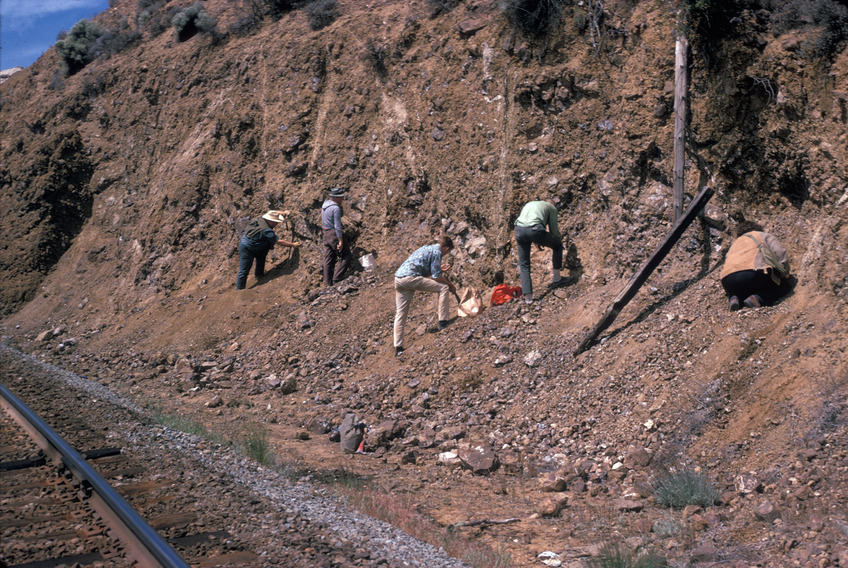
A weathered Miocene pillow basalt located on the north side of Kamloops Lake, exposed by a railroad cut.
The type locality for ferrierite-Mg as recorded for specimen no. F3909 in the Ferrier Collection, Redpath Museum, McGill University, donated by W.F. Ferrier in 1917, is "1/2 mile W. of milepost 17, CN Ry., N. Shore, Kamloops Lake, BC."
This specimen and "several [other] pieces, with rock, vial, and thin section" are considered to be the type material.
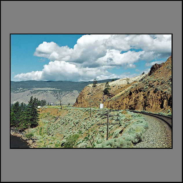
Kamloops Lake in British Columbia, Canada is situated on the Thompson River just west of Kamloops. The lake is 1.6 km wide, 29 km long, and up to 152 m deep. In prehistoric time, the lake was much longer, perhaps 20x, with adjacent silt cliffs defining ancient lake bottoms 100 meters higher than present water levels. At the outlet near Savona, a large tumbled rock, gravel moraine indicates the toe of a glacier once melted away here. The community of Savona is located at the west end of the lake, near the Thompson River outlet. The city of Kamloops is located a few miles east of the head of the lake, at the confluence of the North and South Thompson Rivers. The name, Kamloops, derives from a local Indigenous word, Tk’emlúps, meaning a meeting of waters.
The lake is bounded on all sides by steep hillsides, with level areas found only near creek deltas and around the inlet. On these hills, fresh, green grass feeds herds of Mule Deer and Rocky Mountain Sheep in the Spring. The Canadian National Railroad runs along the North shore, and the Canadian Pacific Railroad along the South shore. The surrounding land is mostly dedicated to beef cattle ranching. It is classified as dry belt interior grasslands, Semi-arid desert, as it is in the rain shadow of the Coast Mountain Range, averaging only 10 inches (ca. 25 cm) of total precipitation a year. Vegetation is mostly bunch grass and sagebrush, with pockets of Douglas fir, Ponderosa pine and spruce.
Kamloops Lake is a widening and deepening of the Thompson River, which enters at the east end and exits at the west end. The limnology of the lake is controlled by the Thompson River, which has high fluctuations in annual flow, with over 60% occurring in the early summer during freshet (May to July). Lake levels rise naturally, as much as 30 feet (ca. 9 m), on average, from winter lows till late June. Infrequent flood years have brought it up another 5 to 10 feet (ca. 3 m). Consequently, rare sandy beach areas expand by as much as 200 feet (ca. 61 m) in the summer as lake levels recede in July and August.
Bulk residence times (the time it takes for the water in the lake to be replaced with new water), are very short, ranging from 20 days to 340 days, with a mean of 60 days. Because Kamloops Lake is fed by both the North and South Thompson rivers (the South Thompson drains from the very warm Shuswap Lakes, 230 meters deep), Kamloops Lake is relatively warm. It rarely freezes over in Winter. Since the late twentieth century, it has become an increasingly popular boating and recreational area. On the north side of the lake is Fredrick, and on the south side of the lake is Savona, and rural residential areas such as Cherry Creek and the Tobiano resort community. At the East end of the lake are the remains of Tranquille, a Tuberculosis Sanatorium, built in 1907 & finally closed in 1983; limited day use only access to the lakeshore exists here. A boat launch, trestle, and gas dock have been built at Tobiano; it is the only location on Kamloops Lake with these facilities. Steelhead Provincial Park is a campsite in Savona, on the far western shore of the lake. Both Savona and Kamloops also have boat launches, but their use is dependent on water levels.
Select Mineral List Type
Standard Detailed Gallery Strunz Chemical ElementsDetailed Mineral List:
| ⓘ Calcite Formula: CaCO3 Habit: Occurs as massive nodules in a weathered pillow basalt; less commonly, as euhedral xls filling geodes associated with Ferrierite-Mg and quartz xls. Description: The calcite nodules occuring at this locality frequently serve as the host phase for thin plates of quartz, var. chalcedony and Ferrierite-Mg. |
| ⓘ Clinoptilolite-Na Formula: Na6(Si30Al6)O72 · 20H2O Habit: As equant crystals of simple morphology; {100} dominant, with {010} smaller, terminated by {101} and {011}. Colour: colorless to orange to reddish Fluorescence: none Description: Occurs as clusters of crystals to 2mm, frequently on a thin crust of chalcedony, often in association with Ferrierite-Mg. Analysis indicates that it is distinctly Na-dominant, with Na>Mg>Ca>K>Ba>Sr |
| ✪ Ferrierite-Mg (TL) Formula: [Mg2(K,Na)2Ca0.5](Si29Al7)O72 · 18H2O Type Locality: Habit: As crystals up to 15mm long (although more commonly of sub-millimeter size), commonly forming divergant clusters of crystals. Crystals are elongated parallel to c axis, with [100} dominant, and smaller {010} and {110}, terminated by {101}. Colour: Colorless, pink, orange and reddish. Fluorescence: None Description: Occurs in calcite nodules in a weathered pillow basalt, commonly associated with spherulitic masses and thin crusts of quartz var.chalcedony,and less commonly with equant clinoptilolite crystals. Uncommonly occurs as geodes reaching 13x30cm lined with Ferrierite-Mg, quartz (sometimes var.amethyst) and acicular goethite. References: |
| ⓘ Goethite Formula: α-Fe3+O(OH) Habit: Acicular Colour: brown Fluorescence: None Description: Occurs as acicular crystals associated with Ferrierite-Mg and quartz xls in geodes. |
| ⓘ Quartz Formula: SiO2 Colour: colorless, amethyst Fluorescence: none Description: Quartz crystals are an uncommon occurrence associated with Ferrierite-Mg in geodes; some specimens are amethyst in color. |
| ⓘ Quartz var. Chalcedony Formula: SiO2 Habit: As thin crusts and spherulitic masses Colour: white, tan Fluorescence: none Description: Commonly occurs as thin crusts embedded in massive calcite nodules. Frequently associated with Ferrierite-Mg |
Gallery:

List of minerals arranged by Strunz 10th Edition classification
| Group 4 - Oxides and Hydroxides | |||
|---|---|---|---|
| ⓘ | Goethite | 4.00. | α-Fe3+O(OH) |
| ⓘ | Quartz var. Chalcedony | 4.DA.05 | SiO2 |
| ⓘ | 4.DA.05 | SiO2 | |
| Group 5 - Nitrates and Carbonates | |||
| ⓘ | Calcite | 5.AB.05 | CaCO3 |
| Group 9 - Silicates | |||
| ⓘ | Ferrierite-Mg (TL) | 9.GD.50 | [Mg2(K,Na)2Ca0.5](Si29Al7)O72 · 18H2O |
| ⓘ | Clinoptilolite-Na | 9.GE.05 | Na6(Si30Al6)O72 · 20H2O |
List of minerals for each chemical element
| H | Hydrogen | |
|---|---|---|
| H | ⓘ Goethite | α-Fe3+O(OH) |
| H | ⓘ Clinoptilolite-Na | Na6(Si30Al6)O72 · 20H2O |
| H | ⓘ Ferrierite-Mg | [Mg2(K,Na)2Ca0.5](Si29Al7)O72 · 18H2O |
| C | Carbon | |
| C | ⓘ Calcite | CaCO3 |
| O | Oxygen | |
| O | ⓘ Calcite | CaCO3 |
| O | ⓘ Quartz var. Chalcedony | SiO2 |
| O | ⓘ Goethite | α-Fe3+O(OH) |
| O | ⓘ Quartz | SiO2 |
| O | ⓘ Clinoptilolite-Na | Na6(Si30Al6)O72 · 20H2O |
| O | ⓘ Ferrierite-Mg | [Mg2(K,Na)2Ca0.5](Si29Al7)O72 · 18H2O |
| Na | Sodium | |
| Na | ⓘ Clinoptilolite-Na | Na6(Si30Al6)O72 · 20H2O |
| Na | ⓘ Ferrierite-Mg | [Mg2(K,Na)2Ca0.5](Si29Al7)O72 · 18H2O |
| Mg | Magnesium | |
| Mg | ⓘ Ferrierite-Mg | [Mg2(K,Na)2Ca0.5](Si29Al7)O72 · 18H2O |
| Al | Aluminium | |
| Al | ⓘ Clinoptilolite-Na | Na6(Si30Al6)O72 · 20H2O |
| Al | ⓘ Ferrierite-Mg | [Mg2(K,Na)2Ca0.5](Si29Al7)O72 · 18H2O |
| Si | Silicon | |
| Si | ⓘ Quartz var. Chalcedony | SiO2 |
| Si | ⓘ Quartz | SiO2 |
| Si | ⓘ Clinoptilolite-Na | Na6(Si30Al6)O72 · 20H2O |
| Si | ⓘ Ferrierite-Mg | [Mg2(K,Na)2Ca0.5](Si29Al7)O72 · 18H2O |
| K | Potassium | |
| K | ⓘ Ferrierite-Mg | [Mg2(K,Na)2Ca0.5](Si29Al7)O72 · 18H2O |
| Ca | Calcium | |
| Ca | ⓘ Calcite | CaCO3 |
| Ca | ⓘ Ferrierite-Mg | [Mg2(K,Na)2Ca0.5](Si29Al7)O72 · 18H2O |
| Fe | Iron | |
| Fe | ⓘ Goethite | α-Fe3+O(OH) |
Other Databases
| Wikipedia: | https://en.wikipedia.org/wiki/Kamloops_Lake |
|---|---|
| Wikidata ID: | Q317435 |
Other Regions, Features and Areas containing this locality
This page contains all mineral locality references listed on mindat.org. This does not claim to be a complete list. If you know of more minerals from this site, please register so you can add to our database. This locality information is for reference purposes only. You should never attempt to
visit any sites listed in mindat.org without first ensuring that you have the permission of the land and/or mineral rights holders
for access and that you are aware of all safety precautions necessary.
References


Kamloops Lake, Kamloops Mining Division, British Columbia, Canada