I-68 Roadcut, Hancock, Washington County, Maryland, USAi
| Regional Level Types | |
|---|---|
| I-68 Roadcut | Road Cutting |
| Hancock | - not defined - |
| Washington County | County |
| Maryland | State |
| USA | Country |
This page is currently not sponsored. Click here to sponsor this page.


Latitude & Longitude (WGS84):
39° 42' 11'' North , 78° 15' 20'' West
Latitude & Longitude (decimal):
Type:
Köppen climate type:
Nearest Settlements:
| Place | Population | Distance |
|---|---|---|
| Hancock | 1,550 (2017) | 6.5km |
| Berkeley Springs | 766 (2011) | 9.1km |
| Great Cacapon | 386 (2011) | 9.8km |
| Pecktonville | 167 (2011) | 18.5km |
| Needmore | 170 (2017) | 18.5km |
Mindat Locality ID:
274357
Long-form identifier:
mindat:1:2:274357:1
GUID (UUID V4):
debad096-c8c4-40a4-b211-b64979bbf14d
Other/historical names associated with this locality:
Sideling Hill
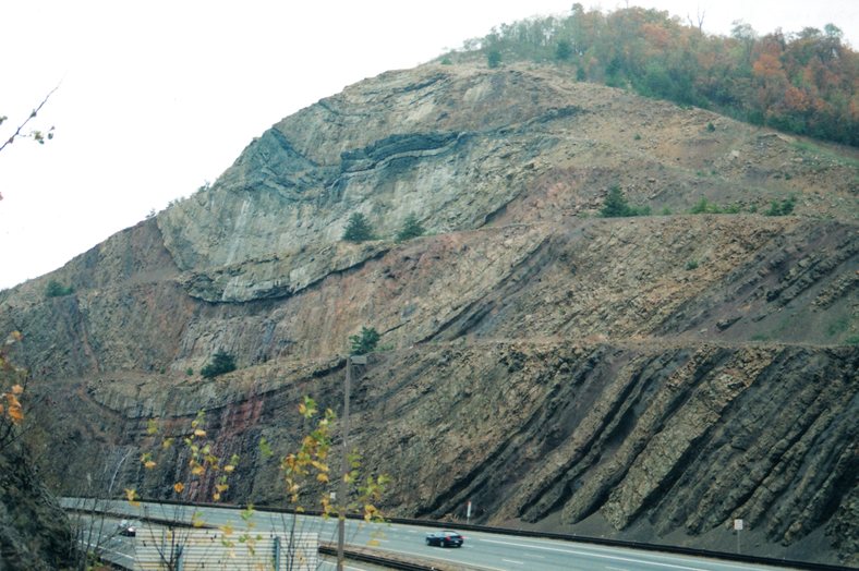
Road cut in Mississippian sandstone, shale, siltstone and minor coal along West traveling side of I-68 outside of Hancock, MD. The road cut displays an excellent tight syncline formed during the Alleghanian Orogeny.
Select Mineral List Type
Standard Detailed Gallery Strunz Chemical Elements
List of minerals arranged by Strunz 10th Edition classification
| Group 4 - Oxides and Hydroxides | |||
|---|---|---|---|
| ⓘ | Quartz | 4.DA.05 | SiO2 |
Other Regions, Features and Areas containing this locality
North America PlateTectonic Plate
- Appalachian BasinBasin
- SCAB DomainDomain
This page contains all mineral locality references listed on mindat.org. This does not claim to be a complete list. If you know of more minerals from this site, please register so you can add to our database. This locality information is for reference purposes only. You should never attempt to
visit any sites listed in mindat.org without first ensuring that you have the permission of the land and/or mineral rights holders
for access and that you are aware of all safety precautions necessary.


I-68 Roadcut, Hancock, Washington County, Maryland, USA