Lahošť, Teplice District, Ústí nad Labem Region, Czech Republici
| Regional Level Types | |
|---|---|
| Lahošť | Municipality |
| Teplice District | District |
| Ústí nad Labem Region | Region |
| Czech Republic | Country |
This page is currently not sponsored. Click here to sponsor this page.


Type:
Largest Settlements:
| Place | Population |
|---|---|
| Lahošt | 544 (2018) |
Mindat Locality ID:
5618
Long-form identifier:
mindat:1:2:5618:5
GUID (UUID V4):
92c07e58-1032-459c-ad54-c2902358455f
Other/historical names associated with this locality:
Loosch
Other Languages:
French:
Lahošť, Teplice, Région d'Ústí nad Labem, République tchèque
German:
Lahošť, Okres Teplice, Ústecký kraj, Tschechien
Italian:
Lahošť, Distretto di Teplice, Regione di Ústí nad Labem, Repubblica Ceca
Spanish:
Lahošť, Distrito de Teplice, Región de Ústí nad Labem, República Checa
Basque:
Lahošť, Ústí nad Labem eskualdea, Txekia
Cebuano:
Lahošt, Okres Teplice, Ústecký kraj, Nasod nga Czech
Czech:
Lahošť, okres Teplice, Ústecký kraj, Česko
Dutch:
Lahošť, Okres Teplice, Ústí nad Labem, Tsjechië
Farsi/Persian:
لاهوشس, شهرستان تپلیتسه, منطقه اوستی ناد لابم, جمهوری چک
Hungarian:
Lahošť, Teplicei járás, Ústí nad Labem-i kerület, Csehország
Malay:
Lahošť, Daerah Teplice, Wilayah Ústí nad Labem, Republik Czech
Minnan / Hokkien-Taiwanese:
Lahošť, Teplice Koān
Polish:
Lahošť, Powiat Cieplice, Kraj ustecki, Czechy
Portuguese:
Lahošť, Teplice, Ústí nad Labem, República Checa
Serbian:
Лахошт, Округ Теплице, Устечки крај, Чешка
Slovak:
Lahošt, okres Teplice, Úsťanský kraj, Česko
South Azerbaijani:
لاهوشس, تپلیتسه بؤلگهسی, اوستی ناد لابم اوستانی, چک جومهوریتی
Swedish:
Lahošt, Teplice , Ústí nad Labem, Tjeckien
Vietnamese:
Lahošť, Teplice, Ústí nad Labem, Cộng hòa Séc
Lahošť, until 2006 Lahošt (German: Loosch) is a village and municipality (obec) in Teplice District in the Ústí nad Labem Region of the Czech Republic.
The municipality covers an area of 3.02 square kilometres (1.17 sq mi).
Lahošť lies approximately 4 kilometres (2 mi) west of Teplice, 20 km (12 mi) west of Ústí nad Labem, and 76 km (47 mi) north-west of Prague.
Fossils of an elasmosaurid plesiosaur were found near this city at the end of the 19th Century. In Hudcov, a nearby village, the plesiosaur Cimoliasaurus teplicensis was described in 1906 by Czech palaeontologist Antonín Frič.
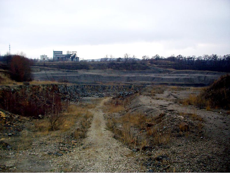
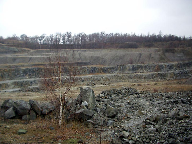
Mesozoic quartzite quarry exploited since 1920. Located between Lahošť and Jeníkov.
NOTE: New extraction activity in part of the quarry, entrance without permission is prohibited!
Select Mineral List Type
Standard Detailed Gallery Strunz Chemical ElementsMineral List
Mineral list contains entries from the region specified including sub-localities6 valid minerals.
Detailed Mineral List:
| ⓘ Baryte Formula: BaSO4 Colour: deep orange Description: From Moore (1990): The crystals, equant and blocky and very sharp, measure up to 3 cm across, and are scattered liberally over flat gray matrixes of a tough quartzite; the largest matrix on hand was about 12 cm across. The crystals are basically a deep orange, and near-gemmy, but a light frostedness on the faces makes them look brownish to gray from any distance. The find is about two years old; collecting is now proceeding, and there will be more of these aesthetically very appealing barites at the next Munich show and (presumably) thereafter. |
| ⓘ Calcite Formula: CaCO3 |
| ⓘ Fluorite Formula: CaF2 |
| ⓘ Pyrite Formula: FeS2 |
| ⓘ Quartz Formula: SiO2 |
| ⓘ Sphalerite Formula: ZnS |

List of minerals arranged by Strunz 10th Edition classification
| Group 2 - Sulphides and Sulfosalts | |||
|---|---|---|---|
| ⓘ | Sphalerite | 2.CB.05a | ZnS |
| ⓘ | Pyrite | 2.EB.05a | FeS2 |
| Group 3 - Halides | |||
| ⓘ | Fluorite | 3.AB.25 | CaF2 |
| Group 4 - Oxides and Hydroxides | |||
| ⓘ | Quartz | 4.DA.05 | SiO2 |
| Group 5 - Nitrates and Carbonates | |||
| ⓘ | Calcite | 5.AB.05 | CaCO3 |
| Group 7 - Sulphates, Chromates, Molybdates and Tungstates | |||
| ⓘ | Baryte | 7.AD.35 | BaSO4 |
List of minerals for each chemical element
| C | Carbon | |
|---|---|---|
| C | ⓘ Calcite | CaCO3 |
| O | Oxygen | |
| O | ⓘ Baryte | BaSO4 |
| O | ⓘ Calcite | CaCO3 |
| O | ⓘ Quartz | SiO2 |
| F | Fluorine | |
| F | ⓘ Fluorite | CaF2 |
| Si | Silicon | |
| Si | ⓘ Quartz | SiO2 |
| S | Sulfur | |
| S | ⓘ Baryte | BaSO4 |
| S | ⓘ Pyrite | FeS2 |
| S | ⓘ Sphalerite | ZnS |
| Ca | Calcium | |
| Ca | ⓘ Calcite | CaCO3 |
| Ca | ⓘ Fluorite | CaF2 |
| Fe | Iron | |
| Fe | ⓘ Pyrite | FeS2 |
| Zn | Zinc | |
| Zn | ⓘ Sphalerite | ZnS |
| Ba | Barium | |
| Ba | ⓘ Baryte | BaSO4 |
Fossils
There are 1 fossil localities from the PaleoBioDB database within this region.BETA TEST - These data are provided on an experimental basis and are taken from external databases. Mindat.org has no control currently over the accuracy of these data.
| Occurrences | 1 |
|---|---|
| Youngest Fossil Listed | 89.3 Ma (Late/Upper Cretaceous) |
| Oldest Fossil Listed | 93.5 Ma (Late/Upper Cretaceous) |
| Fossils from Region | Click here to show the list. |
| Fossil Localities | Click to show 1 fossil locality |
Other Databases
| Wikipedia: | https://en.wikipedia.org/wiki/Laho%C5%A1%C5%A5 |
|---|---|
| Wikidata ID: | Q1800639 |
| GeoNames ID: | 3072345 |
Localities in this Region
- Ústí nad Labem Region
- Teplice District
- Lahošť
- Teplice District
Other Regions, Features and Areas that Intersect
This page contains all mineral locality references listed on mindat.org. This does not claim to be a complete list. If you know of more minerals from this site, please register so you can add to our database. This locality information is for reference purposes only. You should never attempt to
visit any sites listed in mindat.org without first ensuring that you have the permission of the land and/or mineral rights holders
for access and that you are aware of all safety precautions necessary.


Lahošť, Teplice District, Ústí nad Labem Region, Czech Republic