Webb City-Carterville-Prosperity Field, Jasper County, Missouri, USAi
| Regional Level Types | |
|---|---|
| Webb City-Carterville-Prosperity Field | - not defined - |
| Jasper County | County |
| Missouri | State |
| USA | Country |
This page is currently not sponsored. Click here to sponsor this page.


Latitude & Longitude (WGS84):
37° North , 94° West (est.)
Estimate based on other nearby localities or region boundaries.
Margin of Error:
~31km
Köppen climate type:
A galena specimen (F469) in the Ferrier Collection, Redpath Museum, McGill University, is labelled "Prosperity, Missouri".
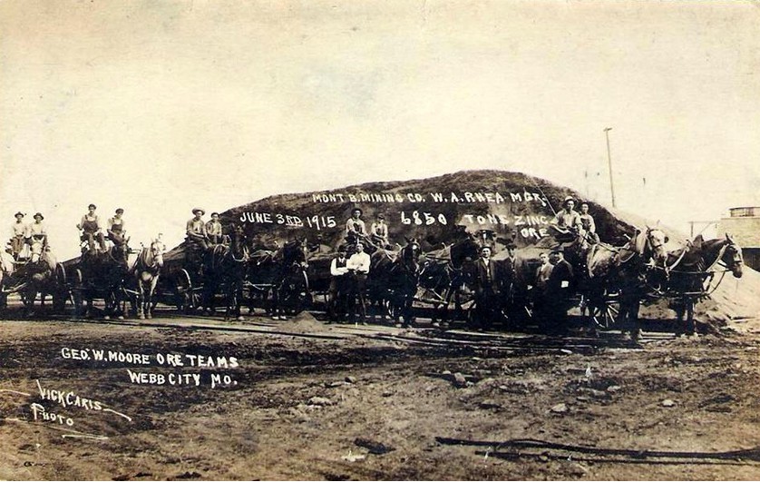
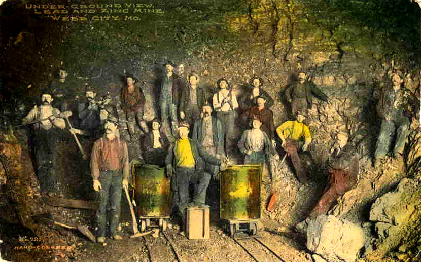
This important camp of southwestern Missouri came into prominence several years later than did Joplin. Apparently, the first discovery of ore here was about 1873, and in the fall of that year prospecting and mining were in progress. Only shallow work was attempted, however, and the shafts did not exceed 30 or 40 feet in depth, at which point limestone, then considered bed-rock, was encountered, and no attempt was made to penetrate it. Within a few years, however, some of the deeper and large bodies were run upon, and the camp soon attained an important position as a producer. It has maintained this position during recent years, even outstripping the Joplin camp. It, therefore, now ranks first in the district, especially in the production of zinc ore.
The outlines of the camp are approximately defined by the limits of the two towns (Webb City, Carterville). These include an area of about 12 square miles, in which most of the mines of the camp occur, though a few mines in outlying adjacent tracts will be considered under this heading.
A very large number of openings have been made in and about Webb City and Carterville. They are especially concentrated along a little stream called Mineral creek, which flows between the two towns. Immediately south and southeast of Carterville is also an area of dense mining. On Mr. Holibaugh’s blue print property map of the two towns of 1893, there are as many as 700 mines located within their limits, and a number more within a distance of a mile or so. It is manifestly as impossible here as with Joplin, to describe and give records of all of these openings, nor could we even locate them on a small map. An attempt to accurately describe even all the most important would prove futile. It is truly lamentable of how few mines any adequate description or history is preserved. No provisions have been made for maps which would show the extent of the workings, and from which the shape and distribution of the ore bodies over the whole camp might be deduced. Many of these workings are now inaccessible.
Select Mineral List Type
Standard Detailed Gallery Strunz Chemical ElementsCommodity List
This is a list of exploitable or exploited mineral commodities recorded from this region.Mineral List
Mineral list contains entries from the region specified including sub-localities10 valid minerals.
Rock Types Recorded
Note: data is currently VERY limited. Please bear with us while we work towards adding this information!
Rock list contains entries from the region specified including sub-localities
Select Rock List Type
Alphabetical List Tree DiagramDetailed Mineral List:
| ⓘ Calcite Formula: CaCO3 Localities: Colour: Lavender Reference: R&M 72:6 pp 400-419 |
| ⓘ Chalcopyrite Formula: CuFeS2 Reference: U.S. Geological Survey,2005,Mineral Resources Data System :U.S. Geological Survey,Reston, Virginia |
| ⓘ Dolomite Formula: CaMg(CO3)2 Reference: U.S. Geological Survey,2005,Mineral Resources Data System :U.S. Geological Survey,Reston, Virginia |
| ⓘ Galena Formula: PbS Localities: Reference: Specimen F469 in the Ferrier Collection, Redpath Museum, McGill University, Montreal, Quebec. |
| ⓘ Goslarite Formula: ZnSO4 · 7H2O |
| ⓘ Goslarite var. Ferro-Goslarite Formula: ZnSO4 · 7H2O Reference: Palache, C., Berman, H., & Frondel, C. (1951), The System of Mineralogy of James Dwight Dana and Edward Salisbury Dana, Yale University 1837-1892, Volume II: 515. |
| ⓘ Greenockite Formula: CdS Reference: Specimen F469 in the Ferrier Collection, Redpath Museum, McGill University, Montreal, Quebec. |
| ⓘ Marcasite Formula: FeS2 Reference: U.S. Geological Survey,2005,Mineral Resources Data System :U.S. Geological Survey,Reston, Virginia |
| ⓘ Pyrite Formula: FeS2 Reference: U.S. Geological Survey,2005,Mineral Resources Data System :U.S. Geological Survey,Reston, Virginia |
| ⓘ Quartz Formula: SiO2 Reference: U.S. Geological Survey,2005,Mineral Resources Data System :U.S. Geological Survey,Reston, Virginia |
| ⓘ Sphalerite Formula: ZnS Localities: Reference: Specimen F469 in the Ferrier Collection, Redpath Museum, McGill University, Montreal, Quebec. |

List of minerals arranged by Strunz 10th Edition classification
| Group 2 - Sulphides and Sulfosalts | |||
|---|---|---|---|
| ⓘ | Chalcopyrite | 2.CB.10a | CuFeS2 |
| ⓘ | Galena | 2.CD.10 | PbS |
| ⓘ | Greenockite | 2.CB.45 | CdS |
| ⓘ | Marcasite | 2.EB.10a | FeS2 |
| ⓘ | Pyrite | 2.EB.05a | FeS2 |
| ⓘ | Sphalerite | 2.CB.05a | ZnS |
| Group 4 - Oxides and Hydroxides | |||
| ⓘ | Quartz | 4.DA.05 | SiO2 |
| Group 5 - Nitrates and Carbonates | |||
| ⓘ | Calcite | 5.AB.05 | CaCO3 |
| ⓘ | Dolomite | 5.AB.10 | CaMg(CO3)2 |
| Group 7 - Sulphates, Chromates, Molybdates and Tungstates | |||
| ⓘ | Goslarite | 7.CB.40 | ZnSO4 · 7H2O |
| ⓘ | var. Ferro-Goslarite | 7.CB.40 | ZnSO4 · 7H2O |
List of minerals for each chemical element
| H | Hydrogen | |
|---|---|---|
| H | ⓘ Goslarite | ZnSO4 · 7H2O |
| H | ⓘ Goslarite var. Ferro-Goslarite | ZnSO4 · 7H2O |
| C | Carbon | |
| C | ⓘ Calcite | CaCO3 |
| C | ⓘ Dolomite | CaMg(CO3)2 |
| O | Oxygen | |
| O | ⓘ Calcite | CaCO3 |
| O | ⓘ Goslarite | ZnSO4 · 7H2O |
| O | ⓘ Goslarite var. Ferro-Goslarite | ZnSO4 · 7H2O |
| O | ⓘ Dolomite | CaMg(CO3)2 |
| O | ⓘ Quartz | SiO2 |
| Mg | Magnesium | |
| Mg | ⓘ Dolomite | CaMg(CO3)2 |
| Si | Silicon | |
| Si | ⓘ Quartz | SiO2 |
| S | Sulfur | |
| S | ⓘ Goslarite | ZnSO4 · 7H2O |
| S | ⓘ Goslarite var. Ferro-Goslarite | ZnSO4 · 7H2O |
| S | ⓘ Galena | PbS |
| S | ⓘ Greenockite | CdS |
| S | ⓘ Sphalerite | ZnS |
| S | ⓘ Chalcopyrite | CuFeS2 |
| S | ⓘ Marcasite | FeS2 |
| S | ⓘ Pyrite | FeS2 |
| Ca | Calcium | |
| Ca | ⓘ Calcite | CaCO3 |
| Ca | ⓘ Dolomite | CaMg(CO3)2 |
| Fe | Iron | |
| Fe | ⓘ Chalcopyrite | CuFeS2 |
| Fe | ⓘ Marcasite | FeS2 |
| Fe | ⓘ Pyrite | FeS2 |
| Cu | Copper | |
| Cu | ⓘ Chalcopyrite | CuFeS2 |
| Zn | Zinc | |
| Zn | ⓘ Goslarite | ZnSO4 · 7H2O |
| Zn | ⓘ Goslarite var. Ferro-Goslarite | ZnSO4 · 7H2O |
| Zn | ⓘ Sphalerite | ZnS |
| Cd | Cadmium | |
| Cd | ⓘ Greenockite | CdS |
| Pb | Lead | |
| Pb | ⓘ Galena | PbS |
References
Sort by
Year (asc) Year (desc) Author (A-Z) Author (Z-A) In-text Citation No.Winslow, Arthur (1894) Lead and Zinc Deposits (Section 2). Missouri Geological Survey, Volume VII: 579.
Localities in this Region
- Missouri
- Jasper County
- Webb City-Carterville-Prosperity Field
- Jasper County
Other Regions, Features and Areas containing this locality
North America PlateTectonic Plate
- Mazatzal DomainDomain
This page contains all mineral locality references listed on mindat.org. This does not claim to be a complete list. If you know of more minerals from this site, please register so you can add to our database. This locality information is for reference purposes only. You should never attempt to
visit any sites listed in mindat.org without first ensuring that you have the permission of the land and/or mineral rights holders
for access and that you are aware of all safety precautions necessary.


Webb City-Carterville-Prosperity Field, Jasper County, Missouri, USA