Sakoany deposit, Katsepy Commune, Mitsinjo District, Boeny, Madagascari
| Regional Level Types | |
|---|---|
| Sakoany deposit | Deposit |
| Katsepy Commune | Commune |
| Mitsinjo District | District |
| Boeny | Region |
| Madagascar | Country |
This page is currently not sponsored. Click here to sponsor this page.


Latitude & Longitude (WGS84):
15° 51' 18'' South , 46° 13' 50'' East
Latitude & Longitude (decimal):
Type:
Köppen climate type:
Mindat Locality ID:
5531
Long-form identifier:
mindat:1:2:5531:7
GUID (UUID V4):
b10f2d75-ca48-4090-83c8-ace778fed454
Other/historical names associated with this locality:
Sankoany
Other Languages:
Malagasy:
Sakoany, Kaominin'i Katsepy, Distrikan'i Mitsinjo, Faritr'i Boeny, Madagasikara
A famous locality that has produced tons of magnificent celestine specimens. It is located near the village of Sakoany, on the western side of the banks of the Betsiboka River (where it empties into the Bombetoka Bay), at the northwestern coast of Madagascar. It is further located about 12 km south of Katsepy, the nearest administrative centre.
The celestine-bearing layer is found in a maximum 30 m thick lens between layers of crinoidal limestones and sandy greywacke of the Danien period (Paleocene, 65 million years old). The celestine occurs mainly as 2 different types: as geodes in varying sizes [Ratsimabazafy (1973) reported a geode about 60 cm in diameter and weighing 54 kg], and as crystal clusters up to 15 cm in diameter. The yearly production is about 15 tons (Pezzotta 1999).
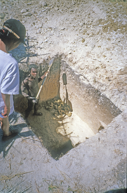
The celestine was first discovered in 1967 and the diggings first started close to the seashore. Later they moved some hundreds of meters away to a higher level (+ 15 m). The locality consists of numerous small, irregular, up to 15 m deep holes in the ground.
See messageboard at http://www.mindat.org/mesg-7-154926.html
Select Mineral List Type
Standard Detailed Gallery Strunz Chemical ElementsCommodity List
This is a list of exploitable or exploited mineral commodities recorded at this locality.Mineral List
1 valid mineral.
Detailed Mineral List:
| ⓘ Celestine Formula: SrSO4 Habit: Blocky to elongated, tapering and pointed, sharp wellformed crystals to 15 cm. Dominant forms: prism {210} moodified by {101} and {011}, + these and {100},{001},{111},{110} Colour: Medium blue to pale blue to colorless with a bright luster References: |

List of minerals arranged by Strunz 10th Edition classification
| Group 7 - Sulphates, Chromates, Molybdates and Tungstates | |||
|---|---|---|---|
| ⓘ | Celestine | 7.AD.35 | SrSO4 |
List of minerals for each chemical element
| O | Oxygen | |
|---|---|---|
| O | ⓘ Celestine | SrSO4 |
| S | Sulfur | |
| S | ⓘ Celestine | SrSO4 |
| Sr | Strontium | |
| Sr | ⓘ Celestine | SrSO4 |
Other Regions, Features and Areas containing this locality
African Plate
- Majunga basinBasin
Madagascar
- ⭔Mahajanga Province (Majunga)Province
Somali PlateTectonic Plate
This page contains all mineral locality references listed on mindat.org. This does not claim to be a complete list. If you know of more minerals from this site, please register so you can add to our database. This locality information is for reference purposes only. You should never attempt to
visit any sites listed in mindat.org without first ensuring that you have the permission of the land and/or mineral rights holders
for access and that you are aware of all safety precautions necessary.
References


Sakoany deposit, Katsepy Commune, Mitsinjo District, Boeny, Madagascar