| Locality type: | Quarry |
| Classification |
|---|
|
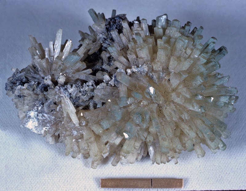
| Species: | Natrolite |
| Formula: | Na2Al2Si3O10 · 2H2O |
| Habit: | prisms averaging 5mm in diameter and 25mm long, rarely up to 2cm wide and 15cm long |
| Colour: | milky white to colourless; less commonly pale pink or grey |
| Confirmation |
|---|
|
| Validity: | Believed Valid |
| Associated Minerals Based on Photo Data: |
|---|
|
| Aegirine | ⓘ217 photos of Natrolite associated with Aegirine at this locality. |
| Analcime | ⓘ185 photos of Natrolite associated with Analcime at this locality. |
| Serandite | ⓘ121 photos of Natrolite associated with Serandite at this locality. |
| Rhodochrosite | ⓘ96 photos of Natrolite associated with Rhodochrosite at this locality. |
| Polylithionite | ⓘ68 photos of Natrolite associated with Polylithionite at this locality. |
| Microcline | ⓘ57 photos of Natrolite associated with Microcline at this locality. |
| Catapleiite | ⓘ52 photos of Natrolite associated with Catapleiite at this locality. |
| Calcite | ⓘ48 photos of Natrolite associated with Calcite at this locality. |
| Gonnardite | ⓘ46 photos of Natrolite associated with Gonnardite at this locality. |
| Albite | ⓘ32 photos of Natrolite associated with Albite at this locality. |
| Data |
|---|
|
| Mineral Data: | Click here to view Natrolite data |
| Locality Data: | Click here to view Poudrette quarry (De-Mix quarry; Demix quarry; Uni-Mix quarry; Carrière Mont Saint-Hilaire; MSH), Mont Saint-Hilaire, La Vallée-du-Richelieu RCM, Montérégie, Québec, Canada |
| Photo Gallery | View Gallery (144 photos) |
| Data Identifiers |
|---|
|
| Mindat Occurrence Record ID: | 8154 |
| Long-form Identifier: | 1:3:8154:2 |
| GUID (UUID V4): | c07faaa6-0a3f-4d4d-87fd-7039f2b9c922 |
| Nearest other occurrences of Natrolite |
|---|
|
|
| 19.5km (12.1 miles) | ⓘDemix-Varennes quarry, Saint-Amable sill, Varennes & St-Amable, Lajemmerais RCM, Montérégie, Québec, Canada |
| 27.6km (17.2 miles) | ⓘLongueuil sill, Longueuil TE, Montérégie, Québec, Canada |
| 31.3km (19.4 miles) | ⓘLafarge Montreal East quarry (Carrière Lafarge Montréal-Est; Francon Montréal-Est quarry; Canada Cement quarry), Montréal-Est, Montréal, Québec, Canada |
| 33.5km (20.8 miles) | ⓘRosemont quarry, Montréal, Québec, Canada |
| 34.7km (21.6 miles) | ⓘMcTavish Reservoir (Rutherford Park; Lower Reservoir; Montreal Reservoir), Mont Royal, Montréal, Québec, Canada |
| 36.2km (22.5 miles) | ⓘFrancon quarry, Montréal, Québec, Canada |
| 37.1km (23.0 miles) | ⓘCorporation (Forsyth's) quarry, Mont Royal, Montréal, Québec, Canada |
| 37.9km (23.5 miles) | ⓘMiron Quarry, Montréal, Québec, Canada |
| 38.6km (24.0 miles) | ⓘCanadian National Railway tunnel, Mont Royal, Montréal, Québec, Canada |
| 72.2km (44.9 miles) | ⓘHusereau Hill, Oka, Deux-Montagnes RCM, Laurentides, Québec, Canada |
| References |
|---|
|
Lykova, I., Rowe, R., Poirier, G., Friis, H., Helwig, K. (2024) Mckelveyite group minerals – Part 3: Bainbridgeite-(YCe), Na₂Ba₂YCe(CO₃)₆\,\cdot\,3H₂O, a new species from Mont Saint-Hilaire, Canada. European Journal of Mineralogy, 36 (1) 183-194 doi:10.5194/ejm-36-183-2024 |


Poudrette quarry, Mont Saint-Hilaire, La Vallée-du-Richelieu RCM, Montérégie, Québec, Canada