| Locality type: | Quarry |
| Classification |
|---|
|
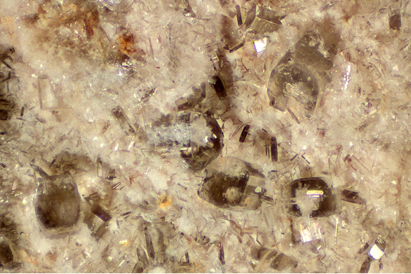
| Species: | Bertrandite |
| Formula: | Be4(Si2O7)(OH)2 |
| Comments: | drusy micro crystals coating cavities, also probably pseudomorphous after beryl |
| Habit: | tabular to equant |
| Colour: | colorless |
| Confirmation |
|---|
|
| Validity: | Believed Valid |
| Data |
|---|
|
| Mineral Data: | Click here to view Bertrandite data |
| Locality Data: | Click here to view Fillow Quarry (Branchville Quarry; Branchville Mica Mine; Smith Mine), Branchville, Redding (Reading), Fairfield County, Connecticut, USA |
| Data Identifiers |
|---|
|
| Mindat Occurrence Record ID: | 130882 |
| Long-form Identifier: | 1:3:130882:2 |
| GUID (UUID V4): | 84deb3aa-ca5f-4eef-98c7-f19a7f01d06d |
| Nearest other occurrences of Bertrandite |
|---|
|
|
| 7.2km (4.5 miles) | ⓘCasey Quarry (Ridgefield pegmatite), Ridgefield, Fairfield County, Connecticut, USA |
| 12.1km (7.5 miles) | ⓘBiermann Quarries (Bethel quarries) and tourmaline ledge, Bethel, Fairfield County, Connecticut, USA |
| 13.1km (8.1 miles) | ⓘCaptain Cook's Quarry (Purdy Station Quarry), Newtown, Fairfield County, Connecticut, USA |
| 17.6km (10.9 miles) | ⓘOld Mine Plaza construction site, Long Hill, Trumbull, Fairfield County, Connecticut, USA |
| 18.5km (11.5 miles) | ⓘBedford, Westchester County, New York, USA |
| 18.8km (11.7 miles) | ⓘBaylis Quarry (Bayliss Quarry), Bedford, Westchester County, New York, USA |
| 19.4km (12.0 miles) | ⓘState Route 25 road cuts, Trumbull, Fairfield County, Connecticut, USA |
| 20.1km (12.5 miles) | ⓘTrumbull, Fairfield County, Connecticut, USA |
| 20.7km (12.9 miles) | ⓘU. S. Route 7 Expressway (Danbury line to Iron Works District), Brookfield, Fairfield County, Connecticut, USA |
| 24.0km (14.9 miles) | ⓘBrookfield, Fairfield County, Connecticut, USA |
| References |
|---|
|
|


Fillow Quarry, Branchville, Redding, Fairfield County, Connecticut, USA