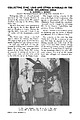
 | | Journal (article/letter/editorial) | | COLLECTING ZINC, LEAD AND OTHER MINERALS IN THE PICHER, OKLAHOMA AREA By GARDINER E. GREGORY Director: The...states. We enjoyed excellent collecting in the Picher, Oklahoma ar~a. . My wI~e Anne and 1 were accompanied...trailer, and the Romalewski' s tented out. The Picher area contains a zinc-lead deposit, which also extends...drilling near Commerce, Oklahoma. By 1916 large scale operations existed in the Picher Field. The decline or...meteoric rise of the Picher Field. The largest mining company in the area is the Eagle-Picher Corporation, who |  | | Journal (article/letter/editorial) | | Houston, Texas 77036 ROBERT 0. FAY Oklahoma Geological Survey Norman, Oklahoma 73019 Downloaded by [The Aga...713 15th Street NW Ardmore, Oklahoma 73401 OKLAHOMA Figure 1. Oklahoma counties. Mineral Locality...known for its gypsum crystals and barite roses, Oklahoma also boasts a variety of other species, including...unaware of the variety of minerals available from Oklahoma and think primarily of the prolific gypsum crystals...hundred years, extends into the northeast corner of Oklahoma and has produced notable specimens. Unfortunately |  | McClung, Craig, Bair, Dorinda, Leach, David L. (1998) Bibliography pertaining to the Ozark Mississipi Valley-type metallogenic province, Missouri, Arkansas, Kansas, and Oklahoma, USA covering 1785 to February 1998; paper edition. Open-File Report Vol. 1998 (98-238) US Geological Survey doi:10.3133/ofr98238 | Report (issue) | | METALLOGENIC PROVINCE, MISSOURI, ARKANSAS, KANSAS, AND OKLAHOMA, USA COVERING 1785 TO FEBRUARY 1998; PAPER EDITION...Missouri, including Westside-Webber Mine, Oklahoma, 10th Annual Field Trip, Sept. 1963: Columbia, MO, Association...Missouri Geologists, 1979, Viburnum Trend -26th annual field trip guide, in Paarlberg, N., ed.: Columbia, MO...Bardy, L. L., 1990, Field guide for the Kansas portion of the coal geology field trip and the Tri-State...Paragenesis of the Tri-State jasperoid [Missouri-Kansas-Oklahoma]: Economic Geology, v. 46, no. 6, p. 652-657. |  | | Report (issue) | | Oklahoma, A Summary of Activities of the U.S. Geological Survey, Water Resources Division, in Fiscal...GEOLOGICAL SURVEY OPEN-FILE REPORT 94-38 Oklahoma City, Oklahoma 1994 U.S. DEPARTMENT OF THE INTERIOR...NW 66th Street, Building 7 Box 25286, MS 517 Oklahoma City, OK 73116 Denver, CO 80225 CONTENTS Page.............................................. 3 Oklahoma District organization chart.....................Types of investigations and sources of funding for Oklahoma in 1991-92................................ 5 List |  | | Report (issue) | | OKLAHOMA, A SUMMARY OF ACTIVITIES OF THE U.S. GEOLOGICAL SURVEY, WATER RESOURCES DIVISION, IN FISCAL...GEOLOGICAL SURVEY Open-File Report 91-492 Oklahoma City, Oklahoma 1991 U.S. DEPARTMENT OF THE INTERIOR...Water Resources Division 202 NW 66** St., Bldg. 7 Oklahoma City, OK 73116 Copies of this report can be purchased...the U.S. Geological Survey .............. 3 Oklahoma District organization chart 4 ................Types of investigations and sources of funding for Oklahoma in 1988-90 List of cooperators ...... 5 .. |  | | Report (issue) | | OKLAHOMA A Summary of Activities of the U.S. GEOLOGICAL SURVEY WATER RESOURCES DIVISION in Fiscal Years...GEOLOGICAL SURVEY Open-File Report 88-172 Oklahoma City, Oklahoma 1988 DEPARTMENT OF THE INTERIOR DONALD...Resources Division 215 Dean A. MoGee, Room 621 Oklahoma City, Oklahoma 73102 Copies of this report can be purchased...Conservancy Dist. Oklahoma Conservation Commission USQS Cooperative Matching Funds Oklahoma Dept. of Transportation...Transportation Oklahoma Water Resources Board City of Oklahoma City Grand River Dan Authority Central Oklahoma |  | | Journal (article/letter/editorial) | | source of this specimen (N 9966) is not known. A sulphur isotope study (galena 53as = +0.8%., sphalerite...are consistent with a magmatic origin for the sulphur and confirm the textural observation that the galena...Reactor Centre, East Kilbride, Glasgow for the sulphur isotope data and 386 I. K. BONEV AND C. M. RICE...interpreting Viburnum Trend mineralization based on field studies at Ozark Lead Company, southeast Missouri...(1970) Geology and ore deposits of the Picher field, Oklahoma and Kansas. U.S. Geol. Survey Prqf Paper |  | | Journal (article/letter/editorial) | | somewhat larger degree of overlap with the MVT field. ED The loadings of PC 1 indicate that the elements...cations (in the case of coupled substitution), and sulphur fugacity, fS2. However, a detailed discussion of...note CE PT that the closure temperature for sulphur isotope fractionation between sulphides, particularly...leaves many open questions: What is the effect of sulphur fugacity, pH or redox-potential? To what extent...of the Lordsburg mining dis- RI trict, Hidalgo County, New Mexico (MSc thesis) New Mexico Institute of |  | | Report (issue) | | underground mines in the Picher Field, Northeastern Oklahoma. Norman : University of Oklahoma, 1986. (244) Ok5c...RESOURCES CHILTON COUNTY MAPS. Rheams, Karen F. Mineral resources map of Chilton County, Alabama. Tuscaloosa...RESOURCES SHELBY COUNTY MAPS. Tew, Berry H. Mineral resources map of Shelby County, Alabama. Tuscaloosa...1985. 784 R312 ARIZONA MINERAL RESOURCES MOHAVE COUNTY. Ryan, George S. Mineral investigation of the...Wilson Wilderness study area (AZ-020-001A), Mohave County, Arizona. [Washington, D.C.] : U.S. Dept. of the |  | | Report (volume) | | maps included. Subject. .Subject. Areas covered by field trips. History of various organizations or geological...mineralogic, paleontologic, etc. Listed by name of field. Subject and area. Subject and area. Subject and...Gems and gem materials. Cunacla, Baffin Island ': Field. D. S. M. 3 Emerald, absorption spectrum : .A-oclerson...rather than indexed separately. The San Ardo oil field is not found under S, but in its proper alphabetical...series. Ottawa. Canada Dominion Observatory Pubs. Canada r»ominion Observatory Publica- tions. Ottawa. Canada |  | Amstutz, G. C., Goresy, A. El, Frenzel, G., Kluth, C., Moh, G., Wauschkuhn, A., Zimmermann, R.A. - Eds. (1982) Ore Genesis. Springer Berlin, Heidelberg. doi:10.1007/978-3-642-68344-2 | Book | | have undergone a decisive shift, not only in our field of research but also in many neighboring natural...the Tri-State District of Missouri, Kansas, and Oklahoma, U.S.A. R.D. Hagni (With 6 Figures) . . . . ....balance ores are concentrated only within the ore field of the "Conrad" Mine (Konstantinovich 1972; Narkelun...conglomerate sequence. To the east and south of the ore field of the "Conrad" Mine, the "cop- 12 Yu.V. Bogdanov...times greater than that of the Dzhezkazgan ore field. Thus, the largest copper deposits of Poland, no |  | | Report (issue) | | OKLAHOMA: A SUMMARY OF ACTIVITIES OF THE U.S. GEOLOGICAL SURVEY WATER RESOURCES DIVISION FOR 1983 By...GEOLOGICAL SURVEY OPEN-FILE REPORT 83-767 Oklahoma City, Oklahoma 1983 UNITED STATES DEPARTMENT OF THE...Old Post Office Bldg. 215 Dean A. McGee Avenue Oklahoma City, OK 73102 Telephone: (405) 231-4256 CONTENTS............................... 4 OK 79-007 -- Oklahoma water-use data system...........................in Oklahoma............................... 5 OK 70-031 -- Flood-prone area mapping in Oklahoma.... |  | | Journal (article/letter/editorial) | | Valley-Type Mineralization in the Southern Ozark Region, USA Christophe W. Simbo, Adriana Potra, John R. Samuelsen...Valley-Type Mineralization in the Southern Ozark Region, USA, Ore Geology Reviews (2019), doi: https://doi.org/10...Valley-Type Mineralization in the Southern Ozark Region, USA Christophe W. Simbo1, Adriana Potra1 (corresponding...University of Arkansas, Fayetteville, AR 72701, USA 2. Arkansas Archeological Survey, 2475 N Hatch AVE...University of Arkansas, Fayetteville, AR 72701, USA Abstract The Pb and/or Zn deposits of the Tri-State |  | | Report (volume) | | cientlfica Circular Classe classification Company, County Collections Committee Communications Comparative...Canada Bureau of Mines Memorandum Series 90, 91. Ottawa, Canada. Canada Department of Mines and Resources...Annual Reports, years ending 3/31/45 and 3/31/46. Ottawa, Canada. Canada'Geological Survey: Bulletin nos...47-1. Ottawa, Canada. Canadian Alpine Journal vols. 29, no. 2; 30. Banff, Alberta.Canadian Field-Naturalist...Field-Naturalist vols. 59, nos. 5, 6; 60; 61. Ottawa, Canada. Canadian Geographical Journal vols. 32-35. Montreal |  | | Report (issue) | | Donald Bruce 1. A geologic map of a part of Marion County, Missouri: unpublished Masters thesis, Univ....KansasMissouri-Oklahoma-Arkansas: American Assoc. Petroleum Geologists, Tulsa, Oklahoma, 1 sheet, 1966...Branson, Carl C. 1. Patterns of Oklahoma prairie mounds: Oklahoma Geology Notes, vol. 26, no. 11,...1966. 2. Maurice Goldsmith Mehl, 1888-1966: Oklahoma Geology Notes, vol. 26, no. 5, pp. 139-140, portrait...Sole marks in Atoka rocks of platform facies: Oklahoma Geology Notes, vol. 26, no. 9, pp. 236-239, 3 |  | | Report (issue) | | NevadaiGity —'Grass: Valley) iter ore ae ee Shasta County a eee cere asses ee avs Oe ee COlOTAMGS ee Pie...information for any problem in the economicgeologic field. I have not read all the references in the bibliographies...Ontario Nickel Commission, A. T. Wilgress, Printer, Ottawa, Chap. 4, p. 95-286, particularly p. 103-133, 134-209...A. G., and Rickaby, H. C., 1934, Sudbury nickel field restudied: Ont. Dept. Mines, 43d Ann. Rept., v....J. A., 1944, Lower Romaine River area, Saguenay County: Que. Dept. of Mines Geol. Rept. 19, 31 p. (with |  | | Report (issue) | | ......................... Tri-State district, Oklahoma, Kansas, and Missouri ..........................jasperoid-bearing areas in 36. Southwest Missouri, Oklahoma, Kansas, and Arkansas ..........................West) surrounding the common corner of Kansas, Oklahoma, and Missouri, and (6) the lead-zinc "district"...example, Ely, Nev., Leadville, Colo., and the "Picher Field," Okla. 4 JASPEROID IN THE UNITED STATES...example, in the Tri-State district of Kansas, Oklahoma, and Missouri. GEOLOGIC AGE The laboratory methods |  | | Report (issue) | | THE 'miNITY RIVER 'miBUTARY AREA TEXAS AND OKLAHOMA Compiled by 'lHE UNITED STATES DEPAR'IUENT OF...Director ot the Oklahoma State Geolo!ical Survey at l~orman, Oklahoma. The Oklahoma Geological S.urvey...out-of-~rint information on the mineral resources of Oklahoma. · Definition of Trinity River Tributary Area...all or parts ot 141 counties in Tezaa and 68 in Oklahoma. For oonwnience, the Trinity Riwr tributaey area...consideration ot many tactora that are outside the field of the goolor,iat. The present report, 'there- ·· |  | | Journal (article/letter/editorial) | | than sphalerite. Above about 260%, this stability field liea well outside of the normal suliidation state...shape of the diagram, that is, the slopes of all field boundaries, rem&insindependent of temperature and...stability field might be extended to lower temperatures at the expense of the aphalerite field. This effect...showed the experiments to be near the stability field of ZnO. The calculations were oonfirmed by the growth...600°C in the wurtzite stability field and above 600°C in the sphalerite field. The appearance of ZnO is the |  | | Report (volume) | | Resources, Inland Waters Branch Technical Bulletin. Ottawa, Ontario, Canada. Canada Dept. Energy, Mines and...and Resources, Mines Branch Information Circular. Ottawa, Ontario, Canada. Canada Geol. Survey Bull. Canada...Canada. Geological Survey of Canada Bulletin. Ottawa, Ontario, Canada Geol. Survey Econ. Geology Rept...Geology Report. Ottawa, Ontario, Canada. Canada Geol. Survey Geophysics Paper Paper. Ottawa, Ontario, Canada...Canada Map. Ottawa, Ontario, Canada Geol. Survey Mem.- Geological Survey of Canada Memoir. Ottawa, Ontario |  | | Report (volume) | | Petroleum geology concepts: GuzOrogenesis, problems, field man Jimenez, E. J., 9; Salas, and experimental evidence:...Pegmatites, California, southern: Mineralogy and the field geologist Arciniega, V. M. Stevenson, J. S. , 6...Taylor, A., 2. 3. Sedimentation, stratigraphy, and Oklahoma, Ouachita Mts., photoseismic exploration: Krumbein...described. Div. Mines, 1; Jenkins, O. P., Choctaw County, Highway 17 area: 3. Toulmin, L. D., Jr., 3. Minor:...analysis: KelH. D., 5. ler, W. D., 3. Talladega County, hematiteOklahoma, potash agstone, granite magnetite |  | | Book | | Metallogenie Provinee, Missouri, Arkansas, Kansas and Oklahoma, USA D.L. Leaeh ...................................Valley-Type Mud Volcano Mass at Deeaturville, Missouri, USA R.A. Zimmermann and M. Sehidlowski . . . . . . ....study of ore textures. In the present book this field is less developed compared to other aspects. However...controls to mineralization in the Silvermines area, County Tipperary, Ireland. In: Andrew CJ, Crowe RWA, Finlay...carbonate rocks as illustrated by Pine Point ore field. Can Inst Mining Metallur Transa 79:B278-B285 Bethke |  | | Report (volume) | | aspects of Lower Morrow sandstones, northwestern Oklahoma [abs] Shale Shaker, v 14, no 2, p 9, 1963 7980...[V 111-Natl Conf Clays and Clay Mmerals, lith, Ottawa, 1962, Proc New York, Macmtllan Co (lnternat Ser...sectwn of Paleozotc rocks from Butler County to Stafford County, Kansas Kansas Geol Survey Otl and Gas...cross section from Barber County, Kansas, to Caddo County, Oklahoma Oklahoma Geol Survey Gutdebook 13...Desmomestan rocks m the Arkoma Bas10 of east-central Oklahoma· Jour Sed Petrology, v 33, no 2, p 393-410, tllus |  | | Report (volume) | | mapping by airborne infrared imagery techniques: Oklahoma Acad. Sci. Proc. 1970, v. 50,p. l0-18,illus.,...alternating field method and new paleointensity measurements of the Miocene geomagnetic field in Oregon:... Shunsuke. Determination of underground stress field based on inelastic properties of rocks, Chap. 18... A. A. Crystallography of ice on Knob Lake, in Field research in Labrador-Ungava [1965-66]: McGTII Univ...Adams, W. P. (editor). Ten years (1954-1964) of field research in Labrador-Ungava: McGill Univ. Dept. |  | | Journal (article/letter/editorial) | | State Uniz:ersity, Unit, ersity Park, PA 16802, USA Received 15 January 1995; accepted 15 September...= - 5 2 (i.e., just below the sulfate stability field). Thus, barite solubility places an upper limit...activity value falls within the wurtzite stability field as determined by Scott and Barnes (1972) indicating...boundaries of the chalcopyrite/pyrite stability field. Pyrite is ubiquitous in both ore and wall-rocks...calcite, and the chalcopyrite/pyrite stability field (Giordano and Barnes, 1981). Regardless of tempera- |
|


