| Locality type: | Road |
| Classification |
|---|
|
| Species: | 'Lévyne' (not an IMA approved species) |
| Confirmation |
|---|
|
| Validity: | Believed Valid |
| Associated Minerals Based on Photo Data: |
|---|
|
| Tschernichite | ⓘ5 photos of Lévyne associated with Tschernichite at this locality. |
| Analcime | ⓘ2 photos of Lévyne associated with Analcime at this locality. |
| Calcite | ⓘ1 photo of Lévyne associated with Calcite at this locality. |
| Cowlesite | ⓘ1 photo of Lévyne associated with Cowlesite at this locality. |
| Erionite Subgroup | ⓘ1 photo of Lévyne associated with Erionite Subgroup at this locality. |
| Chabazite | ⓘ1 photo of Lévyne associated with Chabazite at this locality. |
| Offretite | ⓘ1 photo of Lévyne associated with Offretite at this locality. |
| Data |
|---|
|
| Mineral Data: | Click here to view Lévyne data |
| Locality Data: | Click here to view Neer Road, Goble, Columbia County, Oregon, USA |
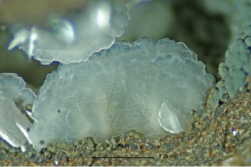
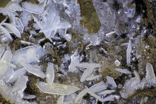
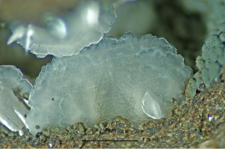
| Photo Gallery | View Gallery (4 photos) |
| Data Identifiers |
|---|
|
| Mindat Occurrence Record ID: | 112812 |
| Long-form Identifier: | 1:3:112812:3 |
| GUID (UUID V4): | 843e55f1-a81e-4182-b32b-667ee4172191 |
| Nearest other occurrences of Lévyne |
|---|
|
|
| 30.7km (19.1 miles) | ⓘBaird Creek Quarry, Wolf Point, Cowlitz County, Washington, USA |
| 31.4km (19.5 miles) | ⓘ200 / 237 Road Quarry, Wolf Point, Cowlitz County, Washington, USA |
| 34.6km (21.5 miles) | ⓘElk Mountain, Toutle, Cowlitz County, Washington, USA |
| 38.8km (24.1 miles) | ⓘSignal Peak, Cowlitz County, Washington, USA |
| 43.2km (26.8 miles) | ⓘBig Tree Creek, Yacolt, Clark County, Washington, USA |
| 49.2km (30.6 miles) | ⓘLacamas Creek, Orchards, Clark County, Washington, USA |
| 66.6km (41.4 miles) | ⓘMilwaukie, Clackamas County, Oregon, USA |
| 67.4km (41.9 miles) | ⓘElk Rock Island, Milwaukie, Clackamas County, Oregon, USA |
| 81.9km (50.9 miles) | ⓘNew Era, Clackamas County, Oregon, USA |
| References |
|---|
|
|
| Reference Search (possible matching items) |
|---|
 | | Journal (issue) | | I205 and come off onto SR14 just north of the Columbia River headed for Camas. From the east, you are...St. Pacific Rim Blvd. Camas Brady Rd. SR 14 Columbia River Exit 10 2 Hungarian Occurrence of Tschernichite...collecting site 3 The andesite excavated by the road cut is strongly eroded. Small veins are noticeable...roadbed of the forest road. Since their first discovery, their origin The road cut at the site between...probably came from a zone which is now covered with the road. The hard, brighter andesite often has both large |  | Pauliš, Petr, Hrůzek, Libor, Janeček, Oldřich, Sejkora, Jiří, Malíková, Radana, Pour, Ondřej, Fediuk, Ferry (2015) Tschernichit, garronit-Ca a doprovodná zeolitová mineralizace z Jehly u České Kamenice (Česká republika) [Tschernichite, garronite-Ca and associated zeolite mineralization from Jehla near Česká Kamenice (Czech Republic)]. Bulletin mineralogicko-petrologického oddělení Národního muzea v Praze, 23 (2) 147-170 | Journal (article/letter/editorial) | | erionite-K, gismondine, heulandite-Ca, chabazite-Ca, lévyne-Ca, natrolite, phillipsite-Ca, stilbite-Ca and...tschernichite, garronite-Ca, chabazite-Ca, analcime, lévyne-Ca, erionite-K, heulandite-Ca, stilbite-Ca, phillipsite-Ca...připomínaly tschernichit z typové lokality Neer Road u Goble v Oregonu (USA). Množství materiálu pro komplexní...objevil R. W. Tschernich v kamenolomu Neer Road Pit u Goble v Oregonu (USA) při výzkumu a popisu cowlesitu...(1993) Tschernichit, a new zeolite from Goble, Columbia County, Oregon. Am. Mineral. 78, 822-826. Coombs D |
|


Neer Road, Goble, Columbia County, Oregon, USA