|
USA | |
|
| (2005) Mineral Resources Data System (MRDS), US Geological Survey. |
|
| (2005) Mineral Resources Data System (MRDS), US Geological Survey. |
|
| (2005) Mineral Resources Data System (MRDS), US Geological Survey. |
|
| (2005) Mineral Resources Data System (MRDS), US Geological Survey. |
|
| (2005) Mineral Resources Data System (MRDS), US Geological Survey. |
|
| Marty, J., Jensen, M.C., Roberts, A.C. (1993) Minerals of the Centennial Eureka Mine, Tintic District, Eureka, Utah. Rocks & Minerals: 68(6): 406-416. |
|
| (2005) Mineral Resources Data System (MRDS), US Geological Survey. |
|
| (2005) Mineral Resources Data System (MRDS), US Geological Survey. |
|
| (2005) Mineral Resources Data System (MRDS), US Geological Survey. |
|
| (2005) Mineral Resources Data System (MRDS), US Geological Survey. |
|
| (2005) Mineral Resources Data System (MRDS), US Geological Survey. |
|
| (2005) Mineral Resources Data System (MRDS), US Geological Survey. |
|
| (2005) Mineral Resources Data System (MRDS), US Geological Survey. |
|
| (2005) Mineral Resources Data System (MRDS), US Geological Survey. |
|
| (2005) Mineral Resources Data System (MRDS), US Geological Survey. |
|
| (2005) Mineral Resources Data System (MRDS), US Geological Survey. |
|
| (2005) Mineral Resources Data System (MRDS), US Geological Survey. |
|
| (2005) Mineral Resources Data System (MRDS), US Geological Survey. |
|
| (2005) Mineral Resources Data System (MRDS), US Geological Survey. |
|
| (2005) Mineral Resources Data System (MRDS), US Geological Survey. |
|
| (2005) Mineral Resources Data System (MRDS), US Geological Survey. |
|
| (2005) Mineral Resources Data System (MRDS), US Geological Survey. |
|
| (2005) Mineral Resources Data System (MRDS), US Geological Survey. |
|
| (2005) Mineral Resources Data System (MRDS), US Geological Survey. |
|
| (2005) Mineral Resources Data System (MRDS), US Geological Survey. |
|
| Kampf, Anthony R., Housley, Robert M., Marty, Joe (2017) Dagenaisite, A New Zinc Tellurate From the Gold Chain Mine, Tintic, Utah, U.S.A. The Canadian Mineralogist, 55 (5) 867-873 doi:10.3749/canmin.1700037 |
|
| (2005) Mineral Resources Data System (MRDS), US Geological Survey. |
|
| American Mineralogist (1969): 54: 1726-1728. |
|
| (2005) Mineral Resources Data System (MRDS), US Geological Survey. |
|
| (2005) Mineral Resources Data System (MRDS), US Geological Survey. |
|
| (2005) Mineral Resources Data System (MRDS), US Geological Survey. |
|
| (2005) Mineral Resources Data System (MRDS), US Geological Survey. |
|
| makalu.jpl.nasa.gov (n.d.) http://makalu.jpl.nasa.gov/docs/workshops/00_docs/Hauff_web.pdf. |
|
| Bullock, Kenneth C. (1981) Minerals and mineral localities of Utah. Bulletin 117. Utah Geological and Mineral Survey |
|
| (2005) Mineral Resources Data System (MRDS), US Geological Survey. |
- North Tintic Mining District
| (2005) Mineral Resources Data System (MRDS), US Geological Survey. |
|
| (2005) Mineral Resources Data System (MRDS), US Geological Survey. |
|
| (2005) Mineral Resources Data System (MRDS), US Geological Survey. |
|
| (2005) Mineral Resources Data System (MRDS), US Geological Survey.
(2005) Mineral Resources Data System (MRDS), US Geological Survey. |
- East Tintic Mining District
| (2005) Mineral Resources Data System (MRDS), US Geological Survey. |
|
| U.S. GEOLOGICAL SURVEY PROFESSIONAL PAPER 1024, |
|
| (2005) Mineral Resources Data System (MRDS), US Geological Survey. |
|
| U.S. GEOLOGICAL SURVEY PROFESSIONAL PAPER 1024, |
|
| (2005) Mineral Resources Data System (MRDS), US Geological Survey. |
|
| (2005) Mineral Resources Data System (MRDS), US Geological Survey. |
|
| (2005) Mineral Resources Data System (MRDS), US Geological Survey. |
|
| (2005) Mineral Resources Data System (MRDS), US Geological Survey. |
|
| (2005) Mineral Resources Data System (MRDS), US Geological Survey. |
|
| (2005) Mineral Resources Data System (MRDS), US Geological Survey. |
- North Tintic Mining District
| (2005) Mineral Resources Data System (MRDS), US Geological Survey. |
|
| Lovering, T. S., & SHEPAKD, A. O. (1960). Hydrothermal argillic alteration on the Helen claim, East Tintic district, Utah. In Clays and clay minerals (pp. 193-202). Pergamon. |
|
| (2005) Mineral Resources Data System (MRDS), US Geological Survey. |
|
| (2005) Mineral Resources Data System (MRDS), US Geological Survey. |
|
| (2005) Mineral Resources Data System (MRDS), US Geological Survey. |
|
| (2005) Mineral Resources Data System (MRDS), US Geological Survey. |
|
| (2005) Mineral Resources Data System (MRDS), US Geological Survey. |
|
| (2005) Mineral Resources Data System (MRDS), US Geological Survey. |
|
| (2005) Mineral Resources Data System (MRDS), US Geological Survey. |
|
| (2005) Mineral Resources Data System (MRDS), US Geological Survey. |

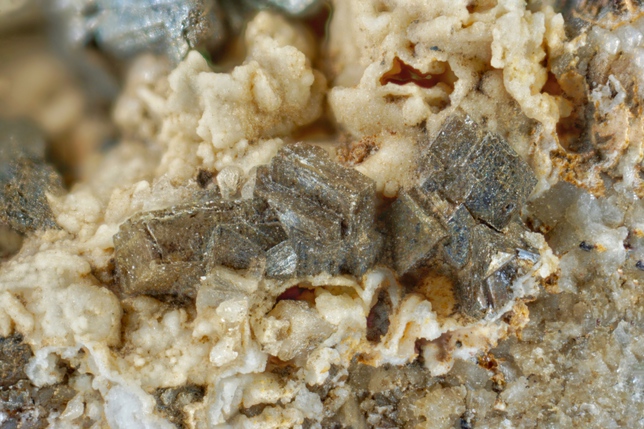


Centennial Eureka Mine, Eureka, Tintic Mining District, Juab County, Utah, USA