| Locality type: | Mine |
| Classification |
|---|
|
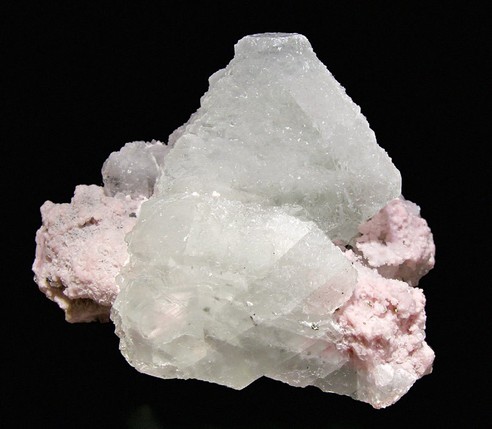
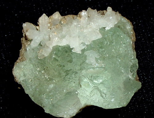
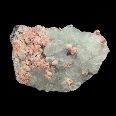
| Species: | Fluorite |
| Formula: | CaF2 |
| Habit: | sharp octahedrons |
| Colour: | grass-green,gray-green,pale lavender,grayish-lavender |
| Confirmation |
|---|
|
| Validity: | Believed Valid |
| Associated Minerals: |
|---|
|
| Associates: | Quartz
Rhodochrosite
|
| Associated Minerals Based on Photo Data: |
|---|
|
| Rhodochrosite | ⓘ147 photos of Fluorite associated with Rhodochrosite at this locality. |
| Quartz | ⓘ93 photos of Fluorite associated with Quartz at this locality. |
| Chalcopyrite | ⓘ9 photos of Fluorite associated with Chalcopyrite at this locality. |
| Pyrite | ⓘ9 photos of Fluorite associated with Pyrite at this locality. |
| Calcite | ⓘ5 photos of Fluorite associated with Calcite at this locality. |
| Sphalerite | ⓘ5 photos of Fluorite associated with Sphalerite at this locality. |
| Tetrahedrite Subgroup | ⓘ1 photo of Fluorite associated with Tetrahedrite Subgroup at this locality. |
| Data |
|---|
|
| Mineral Data: | Click here to view Fluorite data |
| Locality Data: | Click here to view Sunnyside Mine group, Bonita Peak, Gladstone, Eureka Mining District, San Juan County, Colorado, USA |
| Photo Gallery | View Gallery (46 photos) |
| Data Identifiers |
|---|
|
| Mindat Occurrence Record ID: | 133435 |
| Long-form Identifier: | 1:3:133435:7 |
| GUID (UUID V4): | 72cf4781-78de-4346-921c-e56c7122d384 |
| Nearest other occurrences of Fluorite |
|---|
|
|
| 1.1km (0.7 miles) | ⓘSunnyside Extension Mine (Gold Prince Mine), Gladstone, Eureka Mining District, San Juan County, Colorado, USA |
| 1.6km (1.0 miles) | ⓘMountain Queen Mine, Eureka Mining District, San Juan County, Colorado, USA |
| 3.0km (1.9 miles) | ⓘBrown Mountain, Ouray County, Colorado, USA |
| 3.6km (2.2 miles) | ⓘAlaska Mine, Poughkeepsie Gulch, San Juan County, Colorado, USA |
| 4.5km (2.8 miles) | ⓘRansom Mine, Eureka, Eureka Mining District, San Juan County, Colorado, USA |
| 5.0km (3.1 miles) | ⓘFourteen Occurrence, Eureka Mining District, San Juan County, Colorado, USA |
| 5.1km (3.2 miles) | ⓘTom Moore Lode, Eureka Mining District, San Juan County, Colorado, USA |
| 5.2km (3.3 miles) | ⓘIndiana Mine, Gray Copper Gulch, Ouray County, Colorado, USA |
| 5.3km (3.3 miles) | ⓘGaltie Boy - Hercules Mine, Gladstone, Eureka Mining District, San Juan County, Colorado, USA |
| 5.4km (3.3 miles) | ⓘTopeka-Kentucky Giant vein, Gray Copper Gulch, Ouray County, Colorado, USA |
| References |
|---|
|
|
| Reference Search (possible matching items) |
|---|
 | | Report (issue) | | Ore Deposits of the Eureka and Adjoining Districts San Juan Mountains, Colorado By WILBUR S. BURBANK...with the Colorado State Mining Industrial Development Board A study of part of the western San Juan Mountains...___________________ _ San Juan Formation ________________ -------Silverton Volcanic ·Group ___________________...___________________ _ Picayune Formation _______ ------ ______ _ Eureka Tuff ___________________________ _ Burns Formation...Formation _____________________ _ Potosi Volcanic Group ______________________ _ Quaternary deposits __ |  | | Book | | MINES AND MINERALS OF THE GREAT AMERICAN RIFT (COLORADO-NEW MEXICO) Sine —_—< ¢ te om At _SHT 40...MINES AND MINERALS OF THE GREAT AMERICAN RIFT (COLORADO-NEW MEXICO) Richard Walker Holmes and Marrianna...Mines and minerals of the Great American Rift (Colorado-New Mexico). Bibliography: p. Includes index...index. 1. Mines and mineral resources—Colorado. 2. Mines and mineral resources—New Mexico. I. Kennedy, Marrianna...enter must be obtained to prevent trespass. Old mine workings are dangerous and entering underground |  | | Report (issue) | | atemin15cali CALIFORNIA STATE MINING BUREAU FERRY BUILDING, SAN FRANCISCO ^LETCHER HAMILTON State...State Mineralogist [December, 1917 San Francisco] REPORT XV OF THE STATE MINERALOGIST Mines and Mineral...Statement xxiii Participation of the California State Mining Bureau in the Panama-Pacific International Exposition...Production General Features I. Alpine County. 5 6 6 , Mining Districts The Mogul and Monitor Districts...Hercules Company 14 23 Silver Mountain District Silver King District Mineral Water Grover's Hot Springs |  | | Journal (volume) | | f.p. for for:v -" ...THE EN. N o GI "RNAL MINE NI'N NG G. J ou VOLUN/1E JANUARY TO LXIII. ...YORPQ. : - . - ". • : THE ENGINEERING AND MINING JOURNAL. VOLUME LXIII. JANUARY TO JULY, 1897...Aluminum, Prices of.................. 565 Accident Mine, Colo.......... 97 63, 159 Aluminum Reduction, Gooch's...118 Alabama Industrial and Scientific Amador Queen Mine, Cal..... ...... 263 Acetylene Gas, Conner's Pat... Doddridge's Pat...... 487 "Alabama, Johns Coal Mine. 74 Amalgamating Process, FischerAcetylene Gas, |  | | Report (issue) | | 77 GEOLOGY AND ORE DEPOSITS OF THE PARK CITY DISTRICT, UTAH BY JOHN J\IIASON BOUTWELL WITH CO)l"TRIB"CTIO)JS..._____________ ___ _ History and development of the mining industry ....................... . ...... ·............................ . History of Park City district ................. , ............................:::::::::::::::::::::::::::::::::::·::::::::::: Mine workings ............... _·_............ . ............. . Descriptive geology of the Park City district ............................................. |  | | Report (issue) | | 2-Columbia Volcanic Field, Central Idaho River Basalt Group, Western Idaho . .. .. .. . . . . . . . . .. ....rhe Grande Ronde Basalt, Columbia River Basalt Group, From the Lower Salmon River and Northern Hells... . 213 Cenozoic Stratigraphy of Western Owyhee County, Idaho, by E. B. Ekren, D. H. McIntyre, E. H. Bennett...Tuff Volcanic Rocks Near the Idaho-Nevada Owyhee County, Idaho, by John Bernt and Bill Bonnichsen Chapter...of Tertiary-Quaternary Volcanic Rocks in Caribou County, Idaho, by D. W. Fiesinger, W. D. Perkins, and |  | | Journal (volume) | | Cy Mining Magazine Edited by T. RICKARD. A. PUBLISHED AT SALISBURY HOUSE, LONDON...Alaska Alaska Alaska Alaska A. Livingstone Oke Mine (c.l.) A. E. Chodzko [cl.) W. R. Crane (cl.) R-...R- A. Kinzie (cl.) Pumps Coal Juneau Mining Mining Tread wel F. W. Bradley (cl.) 1 Alberta,...Exploitation in Algeria, Mining in 323, (cl.) Alloys, Nomenclature of Alluvial Mining in Urals Altai, The...The Altai, Mining in the Alunite in United States (p.t.) Hutchins J. P. {p.t.) {c.l.) Report Amalgamated |
|


Sunnyside Mine group, Bonita Peak, Gladstone, Eureka Mining District, San Juan County, Colorado, USA