 | Cross, Samuel R.R., Ivanovski, Nikola, Duffin, Christopher J., Hildebrandt, Claudia, Parker, Adam, Benton, Michael J. (2018) Microvertebrates from the basal Rhaetian Bone Bed (latest Triassic) at Aust Cliff, S.W. England. Proceedings of the Geologists' Association, 129 (5) 635-653 doi:10.1016/j.pgeola.2018.06.002 | Journal (article/letter/editorial) | | Rhaetian Bone Bed (latest Triassic) at Aust Cliff, S.W. England Samuel R.R. Crossa , Nikola Ivanovskia...Queens Road, Bristol BS8 1RJ, UK 146 Church Hill Road, Sutton, Surrey SM3 8NF, UK Earth Sciences Department...Natural History Museum, Cromwell Road, London SW7 5BD, UK A R T I C L E I N F O Article history: Received...C T The famous Aust Cliff section, on the east bank of the River Severn, S.W. England, includes one of...widely reported, but the microvertebrates from the Aust Cliff Rhaetian basal bone bed have been barely noted |  | | Report (edition) | | ECONOMIC PRODUCTS : Iron ; Lead ; Zinc ; Barytes ; Celestine ; Gypsum XI . XII . XIII . 35 RHÆTIC 40 LIAS...Tortworth 2 3 15 15 4. Section from north to south across the Silurian Inlier of Tortworth 5. The...vertical sections of the Rhætic Series in Gloucestershire 43 and Somerset 44 16. Comparative vertical...vertical sections of the Lower and Middle Lias in Gloucestershire and Somerset 47 50 17. Sections across the...folded and 24 - faulted Keuper Marls 34 B. Aust Cliff : General view showing red and green Trias Marls |  | | Journal (article/letter/editorial) | | probably as a talus or outwash fan at the foot of a cliff of Carboniferous Limestone which formed part of...The party then travelled by coach via Avonmouth to Aust (566898). From Avonmouth the road follows the Bristol...Channel and is mainly on the twenty-foot terrace. Aust Cliff was approached from the southern end by the road...trending anticline cut by the Severn estuary forming a cliff about one hundred feet high. The face is subject...accessible at the southern and northern ends of the cliff, but for the most part it is necessary to rely on |  | | Journal (article/letter/editorial) | | CHAPTER XV. THE NEOZOIC ROCKS OF GLOUCESTERSHIRE AND SOMERSET. Bv L. RICHARDSON, F .R.S.E ., F .L.S...is unrepresented, as far as can be seen, in Gloucestershire, but is present in many of the Somerset sections...inclined Carboniferous Limestone, is seen in a cliff section between Portishead and Clevedon. § The accumulation... Wainlode.] Garden,' Beachley or Sedbury/'* and Aust Cliffs,tt Milton Lane, near Wells,tt the railway-cutting...portions of the cliffs of Aust and West Somerset; while deposits of celestine, near Yate, * and at Abbots |  | | Report (edition) | | : Iron ; Lead ; Zinc ; Manganese ; Barytes ; Celestine ; Gypsum ; Brick, tile and pottery clays ; Water...sections of the Urwer Carboniferous of Somerset Gloucestershire and Monmouthshire .. somerset, 7. ShOW:ng...41 Section of railway cutting south of Chipping Sodbury, Gloucestershire .. 59 ^“Ces^"ionth.e UPP“...Radstock, Somerset. VII. Aust Cliff 29 .61 VIII. Stinchcombe Hill, Gloucestershire. A view of the Cotswold...near Limpley Stoke X. .. .. 76 .. 77 The south face of the Mendips seen across the alluvial flats |  | | Journal (article/letter/editorial) | | Valley. On the south it may be regarded as including the Mendip Hills and on the south-east as bounded...whole area and threw the rocks into the great north-south and east-west folds which still form the dominant...less elongated periclines ranged en echelon from south-east to north-west. The core of each uplift is worn...conseq uen t st rea m to Malmesb ury : then it turns south wards and ta kes a subsequent cours e nearly parallel...he outs ide by t wo t ribu taries of th e Gloucestershire Frome , and from the inside by a t ributary |  | | Book | | Q. Bowen 3. Caledonian Structures in Britain South of the Midland Valley Edited by J.E. Treagus 4...Emeleus and M.C. Gyopari 5. Igneous Rocks of South-West England PA. Floyd, C.S. Exley and M.T. Styles 6...Quaternary of the Thames 8. Marine Permian of England Edited by J.E. Gordon and D.G. Sutherland D.R...Edited by KJ. Gregory 14. Quaternary of South-West England S. Campbell, C.O. Hunt, J.D. Scourse, D.H...Palmer and N.H. Woodcock 20. Precambrian Rocks of England and Wales J.N. Carney, J.M. Horak, T.C. Pharaoh |  | | Journal (article/letter/editorial) | | I I . - - O n the occurrence of Celestine in the Eeuper marls, and its influence on the composition of...S., &c. R~E origin of the large deposits of Celestine that abound in certain T beds of Triassic age...long been a puzzle to Geologists At Bristol, Celestine is found only on the lowest beds of the Keuper...Oxide. An analysis of some of the concretionary Celestine found at Clifton gave, Strontium Sulphate ..... ~N~LUWNCBo~ CELEST~B ON ~.O~ATION At the well known Aust Cliff, the Keuper marls are well exposed, and form |  | | Journal (article/letter/editorial) | | I I . - - O n the occurrence of Celestine in the Eeuper marls, and its influence on the composition of...S., &c. R~E origin of the large deposits of Celestine that abound in certain T beds of Triassic age...long been a puzzle to Geologists At Bristol, Celestine is found only on the lowest beds of the Keuper...Oxide. An analysis of some of the concretionary Celestine found at Clifton gave, Strontium Sulphate ..... ~N~LUWNCBo~ CELEST~B ON ~.O~ATION At the well known Aust Cliff, the Keuper marls are well exposed, and form |  | | Report (issue) | | formation of ·· · the Rocks of South Wales and South Western England'. The primary 6-in. survey of the...Petrographer. Geological Survey Office, Exhibition Road, South Kensington, London, S.W.7. 25th July, 1960. W.... INDEX . .. Iron Ore, 140.. • • • • Celestine, 14'.2.· I. RECORDS OF RECENT lM.PORTANT BOREHOLES... 67 S.E. 68 N.W. 68 N.E. 68 s.w. 68 S.E. GLOUCESTERSHIRE Hope Mansel .. Mitcheldean • • Englisl1 Bicknor...Severn • • Rockhampton • • • • Mathern Beachley-Aust • • Sudbrook-English Stones • ♦ • • • • • • |  | | Report (issue) | | 21, OF THE (ONE INCH) GEOLOGICAL SURVEY MAP OF ENGLAND. • BY HORACE B. WOODWARD, F.G.S., ;. .. ....Geology, Mineralogy, and Palreontology of Gloucestershire and • Somersetshire, containing references...classification of the Triassic rocks ... in the S.W. of England) .. .Penarth beds (Rhretic) .. List of British...Congresbury-Yeo,.and the ·North Marsh · ... .. 1 54 South or Brent Marsh and the Valley of the Brue .. 1 5...some Eruptive Rocks from Somersetshire and Gloucestershire. By F. RUTLEY • A.l'PENDIX IL-List of Geological |  | | Catalog/List | | Hill, Derbyshire A2 A2 A2 75p 50p £1 £1 Abbots Cliff, Folkestone Mexico (Barstow) Judkins, Warv,ickshire...Whitesmiths Mine, Strontian Galena Italy Stibnite South Crafty, Cornwall Bismuthinite (Fisher) Wheal Fortune...Ladywash, Derbyshire Covelline Arsenopyrite Tremearne Cliff, Cornwall Marcasite Ladywash, Derbyshire Sphalerite...Mine Sphalerite Kit Hill, Cornwall Molybdenite South Crafty, Cornwall Bismuthinite (Carruth) Galena,...A7 A7 £1 50p Hartcliffe Rocks Avon Taffs Well, South Wales A7 A7 £2 75p Utah, USA Cornwall (Fisher) |  | | Journal (article/letter/editorial) | | not appear to be any definite "bone-bed" as at Aust Cliff, but teeth and scales of fish are scattered through... "Baryto-Celestine," apart from its chemical composition, differs from ordinary "Celestine" in the following...obscure. It is much more brittle than the true celestine, weathers to a soft, powdery substance, almost |  | Nickless, E. F. P., Booth, S. J., Mosley, P. N. (1976) The celestite resources of the area north-east of Bristol With notes on occurrences north and south of the Mendip Hills and in the Vale of Glamorgan Description of 1:25 000 resource sheet ST 68 and parts of ST 59, 69, 79, 58, 78, 67 and 77. Mineral Assessment Report 25. Institute of Geological Sciences | Report (issue) | | eld ST76 With notes on occurrences north and south of the Mendip Hills and in the Vale of Glamorgan...of Bristol with notes on occurrences north and south of the Mendip Hills and in the Vale of Glamorgan:...distribution of the mineral south of Bristol, around the lVIendips and in South Wales. The survey was conducted...Institute of Geological Sciences Exhibition Road South Kensington London S\1/7 2DE 1 June 1976 Any enquiries...'I'ytherington-Winterbourne Michaelwood-Wickwar Thornbury- Oldbury Aust-Henbury Wapley- Bitton Yate-Cro1nhall 14 14 14 |  | | Journal (article/letter/editorial) | | with calcits | and occasionally with baryto(_ celestine . Shales, black, less fissile in the 10 upper...another, but are nevertheless nonsequential. On the south side of the pit, namely, that opposite to Glen-Parva...anyone familiar with the Rhastic of the South-West of England is the rarity of hard bands. In the 29 feet...comparable with the Pseudomonotis-Bed of Garden Cliff, which also admits of similar dual division. The...Upper-Rhaetic marls of Wigston were represented at Aust Cliff, and records that he convinced his friend Edward |  | | Book | | S.L. -8 e 1995 | | | | List of ae es ae R Aust ae CC CITC ¥ Dylid dychwelyd eitemau-cyn stampiwyd...complex braided pattern. The coastline lay to the south and was flanked by a tropical sea containing coral...limestones laid down as the sea spread from the south. Gradually the waters became clearer, with the development...Mendips but thickens to over 600 metres to the south. This thickening was probably due to deep faulting...off the Mendips were probably seasonal. To the south, near Puriton, beds of salt accumulated in the evaporating |  | | Book | | A. W. G. Kingsbury LONDON BUTTERWORTHS ■ ENGLAND Butterworth & Co (Publishers) Ltd London: S8 Kingsway...Street Auckland: 35 High Street SOUTH AFRICA Butterworth & Co (South Africa) Ltd Durban: 33/35 Beach...Conservancy, 1970 ISBN 0 40S 70002 5 Printed in England at the Pitman Press, Bath ) I 281495 Contents...Descriptions: Cornwall 17 Devon 39 Dorset 89 Gloucestershire 197 Somerset 217 A Provisional Rough Guide...scientists but mankind in general. Today in south-western England the geologist can examine the strata that |  | | Book | | Memoir for 1:63 360 geological special sheet (England and Wales) B. Owens A. W. A. Rushton G. Warrington...United Kingdom, South Sheet, 3rd edition, 1979 Quaternary map of the United Kingdom, South Sheet, 1977 Aeromagnetic...No. 5 (Middle) Vein of the Farrington Formation south of the Farmborough Fault 108 31 Comparative vertical...of the principal coals of the Radstock Formation south of the Farrnborough Fault 122 38 Sections showing...Triassic and Jurassic rocks in the section at Aust Cliff 133 11 Dolomitic Conglomerate in Bridge Valley |  | | Book | | Black-band Ironstone - . Clay Ironstones - . as a South Wales - - • Mispickel, Pharmacosiderite, &c.... , - North Wales -- - Shropshire . - * South Staffordshire. Warwickshire North Staffordshire...BRITISH Columbia - CANADA, continued - • - South Araica - - - 4 -, • • - - - - - - . 129...Baryto-calcite - - - 150 - SALTs of STRONTIA Celestine and Strontianite * : ---- 11. - - - - :... fine octobedral crystals, with native copper. South Huel Prances, Cornwall. 47. CUPRITE, crystallized |  | | Journal (issue) | | a distance of some 2000 miles overland from the UK. Metal mines in Romania are located within the great...sphalerite ( zinc sulphide) c galena (lead sulphide) _ celestine (strontium sulphate) ~ clear metallic black metallic...in terms of the older sedimentary rocks in the south of the island; the boundary with the igneous rocks...expeditions are well documented in our journal and in the UK Journal of Mines and Minerals (UKJMM). Talisker Bay...midges). You can see the basaltic columns on the cliff face and everywhere there are zeolites. Fine acicular |  | | Report (issue) | | ONE-INCH AND QUARTER- INCH GEOLOGICAL MAPS OF ENGLAND AND WALES. AVAILABILITY OF ONE-INCH GE OLOGICAL...Old Series hand-coloured one-inch maps cover all England and Wales but are out of print; copies are available...(A)-ENGLAND AND WALES • • • • • • 1. South..Western District • • 2. Bristol-Southampton and South Wales...District 3. East Anglia and South-Eastern District 4. 5. 6. 7. 8. • • South Midlands and Central Wales...• • • • • • • • • • • (B)-SCOTLAND: • • 1. South Lowlands District • • • • 2. North Lowlands District |  | | Catalog/List | | Agents for the Sale of Maps and Memoirs iv Page ENGLAND AND '\VA.LES--contd. Maps:Quarter-inch scale 29...Memoirs 85 85 85 86 88 94 94 99 110 111 ISLE OF ENGLAND A.ND WALES : District Memoirs Eruptive Rocks Iron...Harrison. Atkinson & Pollitt. - V AGENTS. - ENGLAND AND WALES-continued. Places. L King's Lynn Provincial...Cooper Bros. Southport .. vV. H. Smith & Son, Ltd. South Shields T. & G. Allan. \V. H. Smith & Son,-- Stafford... R. Platt, Ltd. Wigan .. ~i-7) AS AGENTS. ENGLAND AND WALES-continu~d. Places. P rovincial Agents |  | | Catalog/List | | CATALOGUES, H ANDBOOKS, &c., are sold at the lV!USEUM, South Kensington, London, S. W. 7; and the RoY AL SCOTTISH...Educational Purposes MS. Copies of Six-Inch Maps ENGLAND AND WALES : District Memoirs Eruptive Rocks Iron...SURVEY AGENTS FOR THE SALE OF MAPS, MEMOIRS, &c. ENGLAND AND \.VALES LoNDON: ]2, 13, 14, 15, LONG ACRE...Paine & Co. W . E. Harrison. Ipswich V AGENTS ENGLAND AND WALE8---contint"1d Places. Kendal . . King's...Shrewsbury Southampton .. Southend-on-Sea Southport .. South Shields .. Stafford Stamford .. Stockport .. Stourbridge |  | | Catalog/List | | OF PUBLICATIONS 1 Page ENGLAND AND \VALES--Conld, Maps : (contd.) : England and Wales Quarterinch scale...SURVEY AGENTS FOR THE SALE OF MAPS, MEMOIRS, &c. ENGLAND AND WALES. LONDON: 12, 13, 14, 15, LONG ACRE,...Jackson, Ltd. \V. H. Smith & Son. V AGENTS. ENGLAND AND WALES-continued. Places. Letchworth Lichfield...Shrewsbury Southampton .. Southend-on-Sea Southport .. South Shields Stafford .. Stamford .. Stockport .. Stockton-on-Tees...ECONOMIC Ores: Hrematites of the Forest of Dean and South Wales. (Second MEMOIRS Edition.) Fossil Plants of |  | | Book | | permission of the author. Printed and bound in the UK by: BookPrintingUK Remus House, Coltsfoot Drive,...this time I was also collecting fossils from the Aust Ferry bone beds and various local quarries. In 1975...pits. The company built houses around Torquay, the South Hams and in Honiton. Audrey and I, with our two...Minerals and became regular exhibitors at many of the UK mineral shows over the following years. We also visited...We collected together for many years, both in the UK and on the continent. I also helped Ian out later |
|

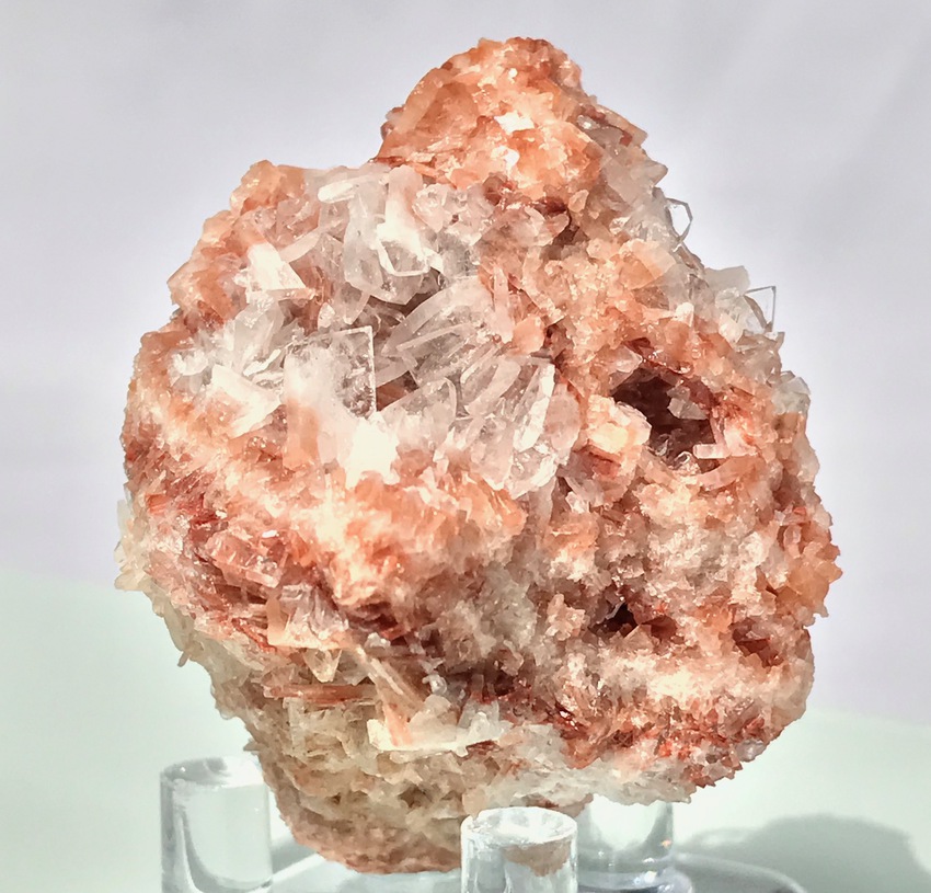


Aust Cliff, Aust, South Gloucestershire, Gloucestershire, England, UK