| Locality type: | Quarry |
| Classification |
|---|
|
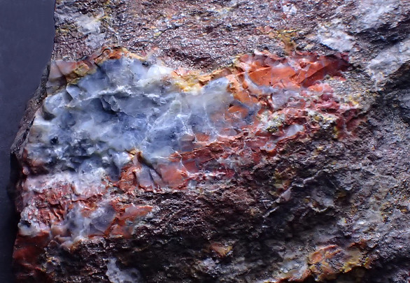
| Species: | Halloysite |
| Formula: | Al2(Si2O5)(OH)4 |
| Confirmation |
|---|
|
| Validity: | Believed Valid |
| Associated Minerals Based on Photo Data: |
|---|
|
| Dravite | ⓘ2 photos of Halloysite associated with Dravite at this locality. |
| Hydrohalloysite | ⓘ1 photo of Halloysite associated with Hydrohalloysite at this locality. |
| Data |
|---|
|
| Mineral Data: | Click here to view Halloysite data |
| Locality Data: | Click here to view Trandorf, Mühldorf, Krems-Land District, Lower Austria, Austria |
| Data Identifiers |
|---|
|
| Mindat Occurrence Record ID: | 268435 |
| Long-form Identifier: | 1:3:268435:2 |
| GUID (UUID V4): | b2fcd9e0-9189-4ece-aeec-96f42b62055d |
| Nearest other occurrences of Halloysite |
|---|
|
|
| 0.6km (0.3 miles) | ⓘTurquoise ditch (Weinberg Forest), Amstall, Mühldorf, Krems-Land District, Lower Austria, Austria |
| 0.7km (0.5 miles) | ⓘRoad cut, Amstall, Mühldorf, Krems-Land District, Lower Austria, Austria |
| 0.9km (0.6 miles) | ⓘGraphite mine, Wegscheid, Mühldorf, Krems-Land District, Lower Austria, Austria |
| 1.5km (0.9 miles) | ⓘGraphite quarry, Amstall, Mühldorf, Krems-Land District, Lower Austria, Austria |
| 63.4km (39.4 miles) | ⓘWaldkirchen an der Thaya, Waldkirchen an der Thaya, Waidhofen an der Thaya District, Lower Austria, Austria |
| 85.9km (53.4 miles) | ⓘLukov hill, Lukov, Třebíč District, Vysočina Region, Czech Republic |
| References |
|---|
|
|
| Reference Search (possible matching items) |
|---|
 | | Journal (article/letter/editorial) | | ©Naturwissenschaftlicher Verein für Kärnten, Austria, download unter www.biologiezentrum.at Carinthia...d e r ö s t e r r e i c h : Meta-Halloysit von Trandorf; fast farbloser Turmalin a s b e s t von der Königsalm;...Many new mineral occurences from various parts of Austria are described in this contribution, from which...ilmenite, aragonite and - for the first time in Austria - g a h n i t e from the Lohning-Bruch near Rauris... ©Naturwissenschaftlicher Verein für Kärnten, Austria, download unter www.biologiezentrum.at From U |  | | Journal (article/letter/editorial) | | MINES AND MINERALS OF AUSTRIA By P H I L I P M O R R I L L East Derby, N . H., 0 3 0 4 1 ( P A R T III)...Realgar. Leoben. Iron Ms. Pyrrhotite; Goethite; Halloysite; Variscite; Wad; Borickite; Lignite. Donawitz...16 Miles Do not scale. Uooer Austria Altaussee tsch# Lower Austria Yugoslav! VII STYR1A ROCKS AND...Zeiring-Aragonite. General. Styria. Chrysocolla. VIII LOWER AUSTRIA (Nieder Oestreich) This includes the city...politically operates in its own area the same as the District of Columbia in Maryland. Zistersdorf, in N E corner |  | | Book | | volcanic ash and larger pyroclastic material on the land surface; in freshwater lakes; shallow marine seas;...different processes depending on whether it fell on the land surface, freshwater lake, or shallow sea; into a...a saline, alkaline lake; or into the ocean. LAND SURFACES Zeolites can form as the result of meteoric...ash or pyroclastic deposits that settled on the land surface, into freshwater lakes, or into a shallow...glassy ash. This ash was carried by the air onto the land surface where it is reworked by streams, shallow | | | Book | | volcanic ash and larger pyroclastic material on the land surface; in freshwater lakes; shallow marine seas;...different processes depending on whether it fell on the land surface, freshwater lake, or shallow sea; into a...a saline, alkaline lake; or into the ocean. LAND SURFACES Zeolites can form as the result of meteoric...ash or pyroclastic deposits that settled on the land surface, into freshwater lakes, or into a shallow...glassy ash. This ash was carried by the air onto the land surface where it is reworked by streams, shallow |  | | Book | | index are distinctive. Garnet and spine! have n1uch lower indices of refraction and are usually highly colored...uneven color, usually purple. Cryolite has even lower index of refraction (n :::::: l.338) and shows weak...Cassiterite and baddeleyite (ZrO 2 ) have much lower birefringence. Anatase and hen1atite are optically...and untwinned, and apatite has lower indices of refraction and lower birefringence. DISTINGUlSHING FEATURES...O 3 in partial solid solution above 1050"C. At lower temperatures, exsolut ion occurs, a nd ilmenite |  | | Journal (issue) | | United Kingdom Operations Murray Hill 3-9294 District BUYERS J-/26 Denny York City Office 370 Lexington...Eire a Republic of MR anya Ceylon DIRECTORY District News Grsaninadl Guiana Malaya Nevada New Mexico...more efficient and economical. Drilling costs are lower, the hole is uniform and clean, and time required...make equally accurate field records from surveys on land, in the air, or over water. Eight plug-in tuner... BIT AND INSERT LIFE MOK HOLE PER-BIT O get lower cost per foot of hole drilled switch to the Timken® |
|


Trandorf, Mühldorf, Krems-Land District, Lower Austria, Austria