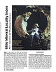
 | | Journal (article/letter/editorial) | | that bring together important locality data for Ohio minerals. It is a contri bution to the national...the Findlay Arch (northwestern Ohio) and Serpent Mound (southwestern Ohio) districts (Carlson 1990); thisvone...thisvone covers concretions, flint, drift minerals, and efflorescences. Like the first, it includes some...such as gypsum crystals from Ellsworth and flint from Flint Ridge (Silliman 1821; Mills 1921). A few sites...Reservoir at mouth of Silver Creek near Edinburg, Portage County. Figure 1 (left). Rosanna Carlson sitting |  | | Report (edition) | | GEOLOGICAL SURVEY 2045 MORSE RD., BLDG. C- 1 COLUMBUS, OHIO 43229-6693 (614) 265-6576 (614) 447-1918 (FAX)...L. Fox, MS, Seismologist Michael C. Hansen, PhD, Ohio Seismic Nelwork (OhioSeis) Coordinator An Equal... Minerals of Ohio by Ernest H. Carlson Bulletin 69 Second Edition STATE OF OHIO DEPARTMENT OF NATURAL...(formerly Stoneco, Inc.}, near Junction, Pau lding County, Ohio. Specimen is 3.8 x 2.4 cm with the largest crystal...citation: Carlson, E.H., 2015, Mineral s of Ohio (2d ed.): Columbus, Ohio Department of Natural Resources, Division |  | | Report (issue) | | Geology and Ground-Water Resources of Portage County, Ohio By JOHN D. \VINSLOW and GEORGE W. WHITE GEOLOGICAL...Prepared in cooperation with of Natural of Water the Ohio Department Resources, Division UNITED STATES ...Chagrin Shale_ _______________ _____ __ _____ __ Ohio Shale (Cleveland Member)______________ Cussewago...Sandstone Member_______________ Glacial deposits of Portage County____________________ Glacial erosion____...18 18 20 20 22 22 23 28 Glacial deposits of Portage County-Continued Wisconsin Glaciation-Continued Cary |  | | Report (issue) | | Bridge) (below International Bridge) near Grand Portage, Minn. Brule River at mouth, near Hoveland, Minn...196419621965- Marquette Iron Range, Marquette County (Chocolay River), low-flow investigation, Mich.......... . 0587 Marquette Iron Range, Marquette County (Escanaba River basin), low-flow investigation.... Silver Lake (head of Silver Lake Outlet) at Portage, Wis. Neenah Creek near Briggsville, Wis ........Creek near Matteson, Mich ......... , .. Branch County, low-flow investigation, Mich ....... . Nottawa |  | | Report (issue) | | Bridge) (below International Bridge) near Grand Portage, Minn. Brule River at mouth, near Hoveland, Minn...•..•..•.•.•...• Marquette Iron Range, Marquette County (Chocolay River), low-flow investigation, Mich...Mich •.•..•.•....• Marquette Iron Range, Marquette County (Escanaba River basin), low-flow investigation...••• Silver Lake (head of Silver Lake Outlet) at Portage, Wis. Neenah Creek near Briggsville, Wis •.•••...Swan Creek near Matteson, Mich ••.••••••.. Branch County, low-flow investigation, Mich •.••••• Nottawa Creek |  | | Report (issue) | | .••••.•••••••• Marquette Iron Range, Marquette County (Chocolay River), low-flow investigation, Mich...Mich •••••.•.. Marquette Iron Range, Marquette County (Escanaba River basin), low-flow investigation...•••••• Silver Lake (head of Silver Lake Outlet) at Portage, Wis. Neenah Creek near Briggsville, Wis ••••....Joseph River at Mendon, Mich ••••••.•••••.•.••••• Portage River near Pavilion, Mich •••••••••••••••.• St...Creek at Hogback Lake Outlet, near Angola (near Flint), Ind. * a d e 929.9 930 932 935 940 945 950 955 |  | | Other Paper | | definitely settled what is Portage and Chemung in Pennsylvania, to the Ohio line, those terms cannot be...subdivisions of these two groups, from the Lake to the Ohio River, yet remain to be worked up. We must keep...produce undulations, folds, or disturbances in the Ohio coal strata, but a close examination does not sustain...years to come, relating to the physical geology of Ohio. Whoever looks through the reports on economical...feet too low. From the southerly part of Coshocton county to the middle of Muskingum and Licking, the connection |  | Ryder, Robert T., Aggen, Kerry L., Hettinger, Robert D., Law, Ben E., Miller, John J., Nuccio, Vito F., Perry, William J., Prensky, Stephen E., Filipo, John J., Wandrey, Craig J. (1996) Possible continuous-type (unconventional) gas accumulation in the Lower Silurian "Clinton" sands, Medina Group and Tuscarora Sandstone in the Appalachian Basin; a progress report of the 1995 project activities. Open-File Report Vol. 1996 (96-42) US Geological Survey doi:10.3133/ofr9642 | Report (issue) | | ............. 7 Figure 3. Map of Chautauqua County, New York showing location and identification numbers................ 22 Figure 11. Map of northeastern Ohio and adjoining Pennsylvania showing land use-land...Sample from Morgan, Noble, and Washington Counties, Ohio .......................... 30 Figure 13. Structure...Packer Shell/Reynales interval in north-central Ohio ............ 32 Figure 14. Map of the northern part...for the Amerada No. 1 Ullman drill hole, Noble County, Ohio ........................................... |  | | Report (volume) | | materials include chert, "chert-clay," conglomerate, flint, gravel,. quartz-mica schist, novaculite, massive...Hartselle sandstone, which crops out in Jefferson County in the northeastern suburbs of Birmingham, has...brown iron ore mines, near Woodstock station, Bibb County, is a bed of sand that is also used in steel foundries...Montgomery Counties [Ark.]: Ark .. Geol. Survey County Mineral Rept. 3, p. 66-74, 87-90. Novaculite is...silica deposits in Fremont County also yield ganister. Analysis of El Paso County sand is given. Averill |  | | Report (issue) | | CURRENT WATER-RESOURCES ACTIVITIES IN OHIO, 1989 Compiled by S. M. Hindall U.S. GEOLOGICAL SURVEY Open-File...Open-File Report 89-58 Columbus f Ohio 1989 DEPARTMENT OF THE INTERIOR DONALD PAUL HODEL, Secretary...Geological Survey 975 W. Third Avenue Columbus, Ohio 43212-3192 U.S. Geological Survey Books and Open-File...been active in water-resources investigations in Ohio for more than 70 years. During that time, volumes...resources of Ohio become increasingly important to its economy and quality of life, the Ohio District's |  | | Report (volume) | | The Foerstia Zone of the Ohio and Chattanooga Shales GEOLOGICAL SURVEY BULLETIN 1294 H The Foerstia...Foerstia Zone of the Ohio and Chattanooga Shales By J. M. SCHOPF and J. F. SCHWIETERING CONTRIBUTIONS TO...discovered occurrence of the Foerstia zone in western Ohio UNITED STATES GOVERNMENT PRINTING OFFICE, WASHINGTON...Geologic cross section across central and northeastern Ohio showing occurrences of the Foerstia zone ......... CONTRIBUTIONS TO STRATIGRAPHY THE FOERSTIA ZONE OF THE OHIO AND CHATTANOOGA SHALES By J. M. SCHOPF and J. F |  | | Report (issue) | | Where possible, references are indexed by State and county to assist in determining areas where additional...Illinois, Indiana, Michigan, Minnesota, New York, Ohio, Pennsylvania and Wisconsin--and all or part of...population. Two counties--Cook County, Illinois, and Cuyahoga County, Ohio--have more than 1 million inhabitants...Interior, 1980). Each reference was coded by State and county if the information was readily accessible. The...base can be searched by author, subject, State, county, and year. The bibliography is in a relational |  | | Report (issue) | | CURRENT WATER-RESOURCES ACTIVITIES IN OHIO, 1987 Compiled by Charlene C. Vince U.S. GEOLOGICAL SURVEY...SURVEY Open-File Report 87-102 Columbus, Ohio 1987 DEPARTMENT OF THE INTERIOR DONALD PAUL HODEL, Secretary...Geological Survey 975 W. Third Avenue Columbus, Ohio 43212 U.S. Geological Survey Books and Open-File...been active in water-resource investigations in Ohio for more than 70 years. During that time, volumes...resources of Ohio become increasingly important to its economy and quality of life, the Ohio District's |  | | Report (issue) | | INDEX OF CURRENT WATER-RESOURCES ACTIVITIES IN OHIO, 1985 Compiled by Michael Eberle U.S. GEOLOGICAL...GEOLOGICAL SURVEY Open-File Report 85-555 Columbus, Ohio 1985 UNITED STATES DEPARTMENT OF THE INTERIOR DONALD...Geological Survey 975 W. Third Avenue Columbus, Ohio 43212 Open-File Services Section Western Distribution...been active in water-resource investigations in Ohio for more than 70 years. During that time, volumes...resources of Ohio become increasingly important to its economy and quality of life, the Ohio District's |  | | Report (issue) | | Geological Survey Open-File Report 93-458 Columbus, Ohio 1993 U.S. DEPARTMENT OF THE INTERIOR BRUCE BABBITT...been active in waterresources investigations in Ohio for more than 70 years. During that time, volumes...resources of Ohio become increasingly important to its economy and quality of life, the Ohio District's...to be an integral part of all investigations. The Ohio District has become involved with the U.S. Department...activities and to a continuing relationship with state, county, local, and other Federal agencies in studying |  | | Report (issue) | | CURRENT WATER-RESOURCES ACTIVITIES IN OHIO, 1991 Compiled by S.M. Hindall and Linda D. Camp U.S. GEOLOGICAL...GEOLOGICAL SURVEY Open-File Report 91-96 Columbus, Ohio 1991 U.S. DEPARTMENT OF THE INTERIOR MANUEL LUJAN...been active in water-resources investigations in Ohio for more than 70 years. During that time, volumes...resources of Ohio become increasingly important to its economy and quality of life, the Ohio District's...State, county, local, and other Federal agencies in studying the water-resources issues of Ohio. Nationally |  | | Journal (article/letter/editorial) | | oxide. . '. a century, become liB obselete as the flInt-lock In such a case I would brace the outSIde by...provided with two or more radiating A. L. H, of Ohio.-You will fail in article to be turned, and which...Butralo, or by ;Lester Hayes, the compiler, Kent, Portage county, OWo. THE lI4.BIETS. GOLD hns ruled quiet...emerge from It, thns relieving BROWN, Albany, Albany County, N. Y.-Tbls Invention relates them of their back...fr�gFlt�l�;;:r��ti[:�. COPPER-Detroi t, 31@.'llM; Portage Lake, 81. mineral whklh Is composed of hydro-sillcate |  | | Journal (article/letter/editorial) | | Investigation of Gilley Fluorspar Deposits in Cherokee County, Alabama, by James F. O'Neill. It is interesting... 50 miles northeast of Birmingham, in Cherokee County, located in West 1/2, West V2 of Section 16, Township...replacement for limestone with the less soluble shale, flint and chert mingled with the barite. California—R...pegmatite district lies across the Park-Fremont County line in south-central Co'crado, a few miles northwest...to us. Will some Colorado reader tell us in what county is Hans Peak and, if possible, send us a few notes |  | | Report (volume) | | with State and local historical societies, State, county, and township officers, and individuals in all...Wyoming, Illinois, superintendent of schools, Stark County, 1882-1898, for much valuable information concerning...several hundred cities and towns, and corrections of county names in the State of Illinois. J. P. Dunn, Indiana...Indianapolis, Indiana, for additions to and corrections of county names. M. W. Davis, State Historical Society, Iowa...fora revision of the complete list of Minnesota county names. Franklin L. Riley, Mississippi Historical |  | | Report (issue) | | ____________________________________________ • _____ - - - - Ohio __________________________________________________________...Massachusetts, Rhode Island, Connecticut, New York, Ohio, Pennsylvania, and New Jersey. To help meet the...Massachusetts, Rhode Island, Connecticut, New York, Ohio, Pennsylvania, and New Jersey (fig. 1). One of the...appraisals of the Nation's ground-water resources-Ohio Region: U.S. Geological Survey Professional Paper...conditioP<; at the site of a proposed Fairfield County jail farm, Trumbull, Connecticut: U.S. Geological |  | | Report (issue) | | ................. ·--------··················-· Ohio: ..... _. __ ................. -- ... ----.-- ....Clay' County ....... __ . __ ... - .... -·- ................ __ .................. 99 Dubois County .............................. _... _.... 100 Greene County __ . _. . :. .. _.. _............ _____ . _......i01 · Knox County .......... __ ................ -.· ....... _................... Owen County._ .........Perry County ... ____ .................... __ • __ .. _............. : .... ~. _-. Pike County ... _ |  | | Report (issue) | | parts of Wisconsin, Michigan, Illinois, Indiana, Ohio, Pennsylvania, New Jersey, Ver mont, Ontario, and...continue with greater and greater refinement. (Flint, 1976, p. 407) Chronologic and correlation schemes...schemes of Flint (1947, 1953, 1955, 1956, 1957), Hough (1953, 1958, 1963, 1966, 1968), Flint and Rubin...(1970), Eschman and Farrand (1970), Prest (1970), Flint (1971, 1976), Sly and Lewis (1972), Terasmae, Karrow...provinces under consideration. Muller (1965a), Flint (1976), and Coates (1976) outlined some of the prob |  | | Report (volume) | | 1 uranium mine, Seven Mile Canyon area, Grand County, Utah: TEI-287, Jan. 11, 1954. GJ, SL. Fischer...exploration at the Old Leyden coal mine, Jefferson County, Colo.: TEM-292, Mar. 30, 1953. D, GJ. Hinrichs...The pegmatites of the Errington-Thiel mine, Elko County, Nevada: TEI-71, Dec. 28, 1949. Office of Director...Ridge, and West End claims near Clancy, Jefferson County, Mont.: TEM-31, Oct. 19, 1951. D, SL, T. (332,...and structure of the Miners Mountain area, Wayne County, Utah: Aug. 17, 1953. SL. McKelvey, V. E., Preliminary |  | | Report (issue) | | Pennsylvanian Part of the Appalachian Basin, Kentucky, Ohio, ses oes eae Socks sagas «iss Ree oa M. Kosanke...000s...60. in the Pottsville Group, Northeastern Ohio ....... Ernie R. Slucher and Charles L. Rice ....the Pennsylvanian deposits are in Pennsylvania, Ohio, and northwestern West Virginia, areas that also...had been traced across Pennsylvania into Ohio. Many of the county and other geologic reports concerning...deposits had been completed in Ohio. Additionally, all of the county geologic reports for the coal-bearing |  | | Report (issue) | | Division offices are shown in figure 1. State, county, and nunicipal agencies participate in the program...Lake Various agencies from five cities and one county disagreed over phosphorus-control regulations for...development of plans for controlling water quality. Ohio: Changes in Aquatic Biota in an Urbanized Watershed...their recolonization. The Geological Survey and the Ohio Department of Natural Resources are cooperating...study in the Big Darby Creek watershed in central Ohio to determine the effects that increasing urbanization |
|


