| Locality type: | Road Cutting |
| Classification |
|---|
|
| Species: | 'Heulandite Subgroup' (not an IMA approved species) |
| Formula: | (Na/Ca/K)5-6[Al8-9 Si27-28 O72] · nH2O |
| Formation: | Primary |
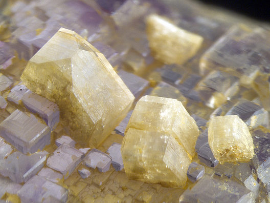
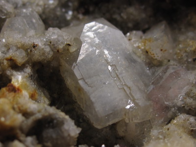
| Comments: | Common in the hydrothermal fault veins with quartz, sphalerite, pyrite, galena. Pearly, translucent crystals usually <1 cm, but rarely up to 2.5 cm. |
| Habit: | coffin-shaped |
| Colour: | colorless to pale yellow or tan |
| Quality for species: | Good crystals or rich for species - important (!) |
| Abundance at site: | Common |
| Confirmation |
|---|
|
| Validity: | Confirmed |
| Confirmation Methods: | Visually Identified |
| Associated Minerals Based on Photo Data: |
|---|
|
| Fluorite | ⓘ7 photos of Heulandite Subgroup associated with Fluorite at this locality. |
| Calcite | ⓘ7 photos of Heulandite Subgroup associated with Calcite at this locality. |
| Quartz | ⓘ7 photos of Heulandite Subgroup associated with Quartz at this locality. |
| Galena | ⓘ6 photos of Heulandite Subgroup associated with Galena at this locality. |
| Pyrite | ⓘ5 photos of Heulandite Subgroup associated with Pyrite at this locality. |
| Stilbite Subgroup | ⓘ5 photos of Heulandite Subgroup associated with Stilbite Subgroup at this locality. |
| Baryte | ⓘ1 photo of Heulandite Subgroup associated with Baryte at this locality. |
| Data |
|---|
|
| Mineral Data: | Click here to view Heulandite Subgroup data |
| Locality Data: | Click here to view Thomaston Dam railroad cut, Thomaston Dam, Thomaston, Litchfield County, Connecticut, USA |
| Photo Gallery | View Gallery (6 photos) |
| Data Identifiers |
|---|
|
| Mindat Occurrence Record ID: | 37861 |
| Long-form Identifier: | 1:3:37861:9 |
| GUID (UUID V4): | c1a70500-0387-4917-a7ae-a17dcab80b1d |
| Nearest other occurrences of Heulandite Subgroup |
|---|
|
|
| 2.5km (1.6 miles) | ⓘThomaston, Litchfield County, Connecticut, USA |
| 5.0km (3.1 miles) | ⓘReynolds Bridge, Thomaston, Litchfield County, Connecticut, USA |
| 5.9km (3.7 miles) | ⓘWaterbury Road quarry, Thomaston, Litchfield County, Connecticut, USA |
| 10.7km (6.7 miles) | ⓘState Route 8 exit 37, Watertown, Litchfield County, Connecticut, USA |
| 11.2km (7.0 miles) | ⓘBlue Stone Quarry, Waterbury, New Haven County, Connecticut, USA |
| 12.3km (7.7 miles) | ⓘTorrington (Wolcottville), Litchfield County, Connecticut, USA |
| 12.8km (8.0 miles) | ⓘUnnamed quarry, Waterbury, New Haven County, Connecticut, USA |
| 18.2km (11.3 miles) | ⓘNonnewaug River Industrial Park, Woodbury, Litchfield County, Connecticut, USA |
| 23.4km (14.5 miles) | ⓘCheshire Traprock Quarry, Cheshire, New Haven County, Connecticut, USA |
| 23.8km (14.8 miles) | ⓘO & G Southbury Quarry (Silliman Quarry; O & G No. 2 Quarry), Orenaug Hills, Woodbury, Litchfield County, Connecticut, USA |
| References |
|---|
|
|


Thomaston Dam railroad cut, Thomaston Dam, Thomaston, Litchfield County, Connecticut, USA