| Locality type: | Village |
| Classification |
|---|
|
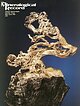
| Species: | Epidote |
| Formula: | (CaCa)(AlAlFe3+)O[Si2O7][SiO4](OH) |
| Confirmation |
|---|
|
| Validity: | Believed Valid |
| Data |
|---|
|
| Mineral Data: | Click here to view Epidote data |
| Locality Data: | Click here to view Dambudas, Rondu, Roundu District, Gilgit-Baltistan, Pakistan |
| Data Identifiers |
|---|
|
| Mindat Occurrence Record ID: | 391497 |
| Long-form Identifier: | 1:3:391497:7 |
| GUID (UUID V4): | 19f9f44e-61ef-4bd9-b215-3867cdf650c7 |
| Nearest other occurrences of Epidote |
|---|
|
|
| 8.6km (5.4 miles) | ⓘTormiq Valley, Haramosh Mts., Roundu District, Gilgit-Baltistan, Pakistan |
| 25.7km (16.0 miles) | ⓘBien Sla, Basha Valley, Shigar District, Gilgit-Baltistan, Pakistan |
| 32.9km (20.4 miles) | ⓘShigar Valley, Shigar District, Gilgit-Baltistan, Pakistan |
| 38.2km (23.8 miles) | ⓘAlchuri, Shigar Valley, Shigar District, Gilgit-Baltistan, Pakistan |
| 38.5km (23.9 miles) | ⓘAlchuri alpine-type clefts, Alchuri, Shigar Valley, Shigar District, Gilgit-Baltistan, Pakistan |
| 42.0km (26.1 miles) | ⓘHashupa epidote occurrence, Hashupa alpine-type clefts, Hashupa, Shigar Valley, Shigar District, Gilgit-Baltistan, Pakistan |
| 42.9km (26.7 miles) | ⓘHashupa alpine-type clefts, Hashupa, Shigar Valley, Shigar District, Gilgit-Baltistan, Pakistan |
| 43.1km (26.8 miles) | ⓘHurchas alpine-type clefts, Shigar Valley, Shigar District, Gilgit-Baltistan, Pakistan |
| 55.4km (34.4 miles) | ⓘShatui Gah, Hanuchal, Gilgit District, Gilgit-Baltistan, Pakistan |
| 56.4km (35.0 miles) | ⓘMakrong Glacier (Makorum Glacier), Hispar Glacier, Hispar, Nagar District, Gilgit-Baltistan, Pakistan |
| References |
|---|
|
|
| Reference Search (possible matching items) |
|---|
 | | Journal (issue) | | from the C en ten n ia l Eureka m in e, T intic district, Juab C ounty, U ta h ..........................end o f the Wallapai Mining District. The major mining centers of the district included Cerbat, Chloride...is gener ally at a stand-still throughout the district. The town of Cerbat played a lively role in the...the Cerbat M ountains and the Wallapai Mining District is extremely complex and beyond the scope of this...mine. DINGS, M. G. (1951) The Wallapai mining district, Cerbat Moun tains, Mohave County, Arizona. U | 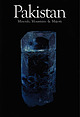 | | Report (issue) | | To Our Readers: Pakistan is a mineralogically-rich and interesting country. The quantity of Pakistani...us by surprise when people began to ask, "Why Pakistan; why now?" It has never been our intention to...the mineral deposits of the high mountains of Pakistan and Afghanistan. Once into the project, however...justice to neither. We decided to limit our focus to Pakistan, though even focused on a single country, a comprehensive...19.6 cm high Shigar Valley, Skardu district, Northern Areas, Pakistan P hoto by Jeff Scovil Collection |
|


