| Locality type: | Municipality |
| Classification |
|---|
|
| Species: | Quartz var: Agate |
| Confirmation |
|---|
|
| Validity: | Believed Valid |
| Associated Minerals Based on Photo Data: |
|---|
|
| Quartz | ⓘ2 photos of Agate associated with Quartz at this locality. |
| Data |
|---|
|
| Mineral Data: | Click here to view Agate data |
| Locality Data: | Click here to view Šonov, Náchod District, Hradec Králové Region, Czech Republic |
| Photo Gallery | View Gallery (20 photos) |
| Data Identifiers |
|---|
|
| Mindat Occurrence Record ID: | 431813 |
| Long-form Identifier: | 1:3:431813:2 |
| GUID (UUID V4): | 93de143f-82e6-4825-85c5-2fae956dc599 |
| Nearest other occurrences of Agate |
|---|
|
|
| 17.0km (10.5 miles) | ⓘNiwa melaphyre outcrops, Niwa, Gmina Szczytna, Kłodzko County, Lower Silesian Voivodeship, Poland |
| 29.9km (18.6 miles) | ⓘBorówno melaphyre quarry, Krzeszów, Gmina Kamienna Góra, Kamienna Góra County, Lower Silesian Voivodeship, Poland |
| 53.8km (33.4 miles) | ⓘRovně, Dolní Kalná, Trutnov District, Hradec Králové Region, Czech Republic |
| 60.1km (37.4 miles) | ⓘLubiechowa quarry, Lubiechowa, Gmina Świerzawa, Złotoryja County, Lower Silesian Voivodeship, Poland |
| 62.6km (38.9 miles) | ⓘLevín hill, Levínská Olešnice, Semily District, Liberec Region, Czech Republic |
| 62.9km (39.1 miles) | ⓘRóżana (Wołek; Kotek Hill), Nowy Kościół, Gmina Świerzawa, Złotoryja County, Lower Silesian Voivodeship, Poland |
| 63.4km (39.4 miles) | ⓘRailway cut, Nowy Kościół, Gmina Świerzawa, Złotoryja County, Lower Silesian Voivodeship, Poland |
| 63.5km (39.5 miles) | ⓘStaropacká hora, Stará Paka (Altpaka), Jičín District, Hradec Králové Region, Czech Republic |
| 63.8km (39.6 miles) | ⓘDynowice, Nowy Kościół, Gmina Świerzawa, Złotoryja County, Lower Silesian Voivodeship, Poland |
| 64.4km (40.0 miles) | ⓘHvězda quarry, Stará Paka (Altpaka), Jičín District, Hradec Králové Region, Czech Republic |
| References |
|---|
|
|


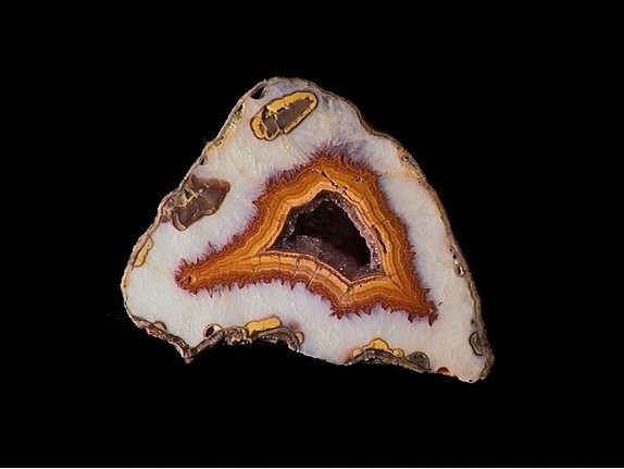

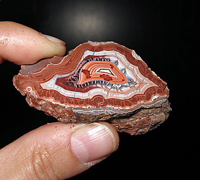


Šonov, Náchod District, Hradec Králové Region, Czech Republic