| Locality type: | Road Cutting |
| Classification |
|---|
|
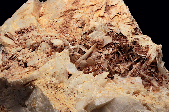
| Species: | Baryte |
| Formula: | BaSO4 |
| Comments: | Abundant as single tabular crystals to more typical slightly divergent, radiating crystal groups in fault veins. Some show etched surfaces. |
| Habit: | tabular to slightly radiating clusters/aggregates |
| Colour: | white |
| Quality for species: | Good crystals or rich for species - important (!) |
| Abundance at site: | Very common |
| Confirmation |
|---|
|
| Validity: | Believed Valid |
| Associated Minerals Based on Photo Data: |
|---|
|
| Quartz | ⓘ5 photos of Baryte associated with Quartz at this locality. |
| Galena | ⓘ4 photos of Baryte associated with Galena at this locality. |
| Dolomite | ⓘ4 photos of Baryte associated with Dolomite at this locality. |
| Malachite | ⓘ3 photos of Baryte associated with Malachite at this locality. |
| Goethite | ⓘ3 photos of Baryte associated with Goethite at this locality. |
| Siderite | ⓘ3 photos of Baryte associated with Siderite at this locality. |
| Bornite | ⓘ2 photos of Baryte associated with Bornite at this locality. |
| Sphalerite | ⓘ2 photos of Baryte associated with Sphalerite at this locality. |
| Azurite | ⓘ1 photo of Baryte associated with Azurite at this locality. |
| Chalcopyrite | ⓘ1 photo of Baryte associated with Chalcopyrite at this locality. |
| Data |
|---|
|
| Mineral Data: | Click here to view Baryte data |
| Locality Data: | Click here to view State Route 9 - Ellis Street and State Route 72 interchanges (State Route 72 roadcut), New Britain, Hartford County, Connecticut, USA |
| Photo Gallery | View Gallery (5 photos) |
| Data Identifiers |
|---|
|
| Mindat Occurrence Record ID: | 47356 |
| Long-form Identifier: | 1:3:47356:1 |
| GUID (UUID V4): | 71bf4729-b1cf-4173-923a-ea2c62c75ee4 |
| Nearest other occurrences of Baryte |
|---|
|
|
| 0.5km (0.3 miles) | ⓘSherrill Street quarry, New Britain, Hartford County, Connecticut, USA |
| 2.8km (1.7 miles) | ⓘHart's Lead Mine, Berlin, Hartford County, Connecticut, USA |
| 4.5km (2.8 miles) | ⓘArute Field, New Britain, Hartford County, Connecticut, USA |
| 4.8km (3.0 miles) | ⓘJourney Road quarry, Plainville, Hartford County, Connecticut, USA |
| 5.2km (3.2 miles) | ⓘPlainville Trap Rock Quarry (Tilcon New Britain Quarry), Plainville, Hartford County, Connecticut, USA |
| 5.8km (3.6 miles) | ⓘFenn Road, Newington, Hartford County, Connecticut, USA |
| 6.1km (3.8 miles) | ⓘThe Woodlands, Newington, Hartford County, Connecticut, USA |
| 6.4km (3.9 miles) | ⓘState Route 9 & State Route 71 Interchange, New Britain, Hartford County, Connecticut, USA |
| 6.5km (4.1 miles) | ⓘState Route 372 construction site, Plainville, Hartford County, Connecticut, USA |
| 6.6km (4.1 miles) | ⓘClark farm (Holler's Mine), Southington, Hartford County, Connecticut, USA |
| References |
|---|
|
|


State Route 9 - Ellis Street and State Route 72 interchanges, New Britain, Hartford County, Connecticut, USA