| Locality type: | Slag Locality |
| Classification |
|---|
|
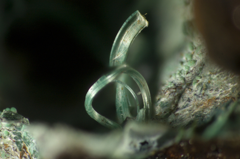
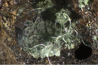
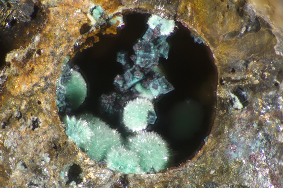
| Species: | Malachite |
| Formula: | Cu2(CO3)(OH)2 |
| Formation: | Post-mining/Anthropogenic |
| Confirmation |
|---|
|
| Validity: | Believed Valid |
| Associated Minerals Based on Photo Data: |
|---|
|
| Langite | ⓘ2 photos of Malachite associated with Langite at this locality. |
| Cuprite | ⓘ1 photo of Malachite associated with Cuprite at this locality. |
| Azurite | ⓘ1 photo of Malachite associated with Azurite at this locality. |
| Brochantite | ⓘ1 photo of Malachite associated with Brochantite at this locality. |
| Data |
|---|
|
| Mineral Data: | Click here to view Malachite data |
| Locality Data: | Click here to view Lechnerberg slag locality, Kaprun, Zell am See District, Salzburg, Austria |
| Photo Gallery | View Gallery (5 photos) |
| Data Identifiers |
|---|
|
| Mindat Occurrence Record ID: | 632899 |
| Long-form Identifier: | 1:3:632899:3 |
| GUID (UUID V4): | cca3a808-d0d7-42d1-aef1-0f072dfe4cca |
| Nearest other occurrences of Malachite |
|---|
|
|
| 5.8km (3.6 miles) | ⓘSlag locality, Judendorf, Fusch an der Grossglocknerstrasse, Zell am See District, Salzburg, Austria |
| 6.0km (3.7 miles) | ⓘKnappenleiten, Fusch an der Grossglocknerstrasse, Zell am See District, Salzburg, Austria |
| 7.4km (4.6 miles) | ⓘGold mines, Schied Alp, Fusch an der Grossglocknerstrasse, Zell am See District, Salzburg, Austria |
| 13.2km (8.2 miles) | ⓘUpper Ferschbach Alp, Ferschbach valley, Fellern, Uttendorf, Zell am See District, Salzburg, Austria |
| 14.2km (8.8 miles) | ⓘViertal Alp (Puderlehen Alp), Uttendorf, Zell am See District, Salzburg, Austria |
| 15.9km (9.9 miles) | ⓘTotenkopf (incl. Lower Riffl glacier), Uttendorf, Zell am See District, Salzburg, Austria |
| 18.2km (11.3 miles) | ⓘSchiedergraben, Mittersill, Zell am See District, Salzburg, Austria |
| 18.5km (11.5 miles) | ⓘGold mines, Kloben (north slope), Fusch an der Grossglocknerstrasse, Zell am See District, Salzburg, Austria |
| 18.9km (11.8 miles) | ⓘNeuschurf adit, Schwarzleo mining district, Schwarzleograben, Hütten, Leogang, Zell am See District, Salzburg, Austria |
| 19.0km (11.8 miles) | ⓘSteinbachtal (Steinbachwände), Rauris, Zell am See District, Salzburg, Austria |
| References |
|---|
|
|
| Reference Search (possible matching items) |
|---|
 | | Journal (article/letter/editorial) | | tunnel walls; weathering products of mine dumps and slag). A second human influence on the distribution of...Zalasiewicz et al. 2008; Waters et al. 2016; however, see Finney and Edwards 2016 for a contrary view). The...0003-004X/17/0003–595$05.00/DOI: http://dx.doi.org/10.2138/am-2017-5875 Anthropocene Epoch, based on terminology...Commission has addressed this question in some detail (see Text Box 1). Their statement highlights the varied...Mine-associated (“post-mine”) minerals Formula Type locality; other localities A. Alteration phases recovered |
|


Lechnerberg slag locality, Kaprun, Zell am See District, Salzburg, Austria