| Classification |
|---|
|
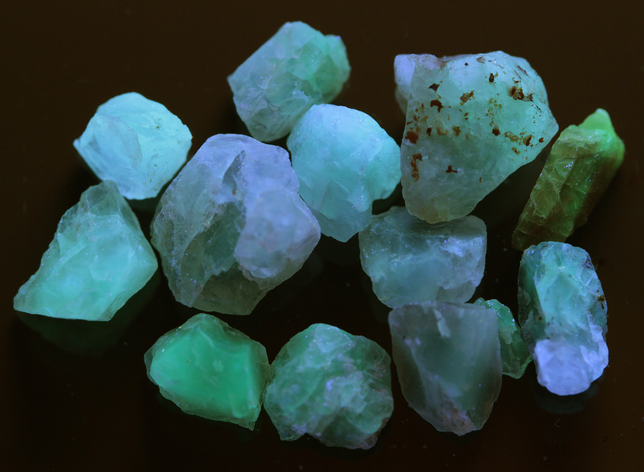
| Species: | Fluorite var: Chlorophane |
| Formula: | CaF2 |
| Comments: | As irregular, cleaving masses with chalcopyrite, plagioclase, pyrite, allanite, bastnaesite. Thermoluminescent. |
| Habit: | massive |
| Colour: | colorless to deep red, pink, purple |
| Quality for species: | Poor for species, only of interest for locality collectors. (#) |
| Abundance at site: | Common |
| Confirmation |
|---|
|
| Validity: | Believed Valid |
| Data |
|---|
|
| Mineral Data: | Click here to view Chlorophane data |
| Locality Data: | Click here to view Linkpot cut, Airline Railroad, East Hampton (Chatham), Middlesex County, Connecticut, USA |
| Data Identifiers |
|---|
|
| Mindat Occurrence Record ID: | 712668 |
| Long-form Identifier: | 1:3:712668:0 |
| GUID (UUID V4): | aeece21e-2aeb-4255-97c4-4c7cfa0654e8 |
| Nearest other occurrences of Chlorophane |
|---|
|
|
| 5.0km (3.1 miles) | ⓘSlocum prospect, East Hampton (Chatham), Middlesex County, Connecticut, USA |
| 9.6km (6.0 miles) | ⓘGillette Quarry (J-J Mine; Haddam Neck Quarry), Haddam Neck, Haddam, Middlesex County, Connecticut, USA |
| 10.3km (6.4 miles) | ⓘRiverside Quarry (Western Quarry), White Rock Mining District, Middletown, Middlesex County, Connecticut, USA |
| 11.7km (7.2 miles) | ⓘHollister prospects, South Glastonbury, Glastonbury, Hartford County, Connecticut, USA |
| 13.9km (8.6 miles) | ⓘHewitt Gem Quarry (Herb's Gem Quarry; Sawmill Quarry), Haddam, Middlesex County, Connecticut, USA |
| 69.4km (43.1 miles) | ⓘCorporate Drive, Long Hill, Trumbull, Fairfield County, Connecticut, USA |
| 69.8km (43.4 miles) | ⓘOld Mine Park (Old Tungsten Mine), Long Hill, Trumbull, Fairfield County, Connecticut, USA |
| 70.0km (43.5 miles) | ⓘOld Mine Plaza construction site, Long Hill, Trumbull, Fairfield County, Connecticut, USA |
| 70.4km (43.7 miles) | ⓘState Route 111 construction site, Long Hill, Trumbull, Fairfield County, Connecticut, USA |
| 86.8km (53.9 miles) | ⓘFillow Quarry (Branchville Quarry; Branchville Mica Mine; Smith Mine), Branchville, Redding (Reading), Fairfield County, Connecticut, USA |
| References |
|---|
|
|


Linkpot cut, Airline Railroad, East Hampton, Middlesex County, Connecticut, USA