 | | Journal (issue) | | can restore the holiday spirit. NEIGC in Bethel, Maine this fall was a lot of fun. My dog Jack and I tented...seismically slow feature underlying parts of New England (USA) likely reflects a volume of significantly elevated...Nation pluton? Photo by Henry N. Berry Bethel, Maine has a new gem and mineral museum and gift shop that...rocks found in various Maine localities. Some gems were from the Havey and Mount Mica pegmatites that are...by Tina Cotton This photo of tourmaline at the Mount Mica site shows the gradation of colors. Note the |  | | Report (issue) | | FIGURE 26. Index map showing area in southwestern Maine and southeastern New Hampshire................ II...II 168 165 STRATIGRAPHY IN SOUTHWESTERN MAINE AND SOUTHEASTERN NEW HAMPSHI~E . . By FRANK INTRODUCTION...which is in the southwest corner of Maine, in Cumberland and York counties, the remainder being in the...ILES 26.-Index map showing area in southwestern Maine and southeastern New Hampshire. meridians 70° and71...Buxton, Newfield, Biddeford, Kennebunkport, Berwick, York, and Dover quadrangles of the United States Geological |  | | Book (volume) | | Mineralogy by Vandall T. King and Eugene E. Foord Maine Geological Survey DEPARTMENT OF CONSERVATION Walter...Descriptive Mineralogy Vandall T. King Rochester, New York 14609 , Eugene E. Foord U S. Geological Survey...Resources Information, Maine Geological Survey Walter A. Anderson, State Geologist Maine Geological Survey...DEPARTMENT OF CONSERVATION 1994 Copyright ©1994 by the Maine Geological Survey, Department of Conservation. All...photograph: Fluorapatite, Pulsifer quarry, Auburn, Maine (2.2 cm specimen), Harvard Mineralogical Museum |  | | Report (volume) | | Summary Results of the Glens Falls CUSMAP Project, New York, Vermont, and New Hampshire U.S. GEOLOGICAL SURVEY... Summary Results of the Glens Falls CUSMAP Project, New York, Vermont, and New Hampshire Edited by JOHN F. SLACK...Summary results of the Glens Falls CUSMAP project, New York, Vermont, and New Hampshire : geologic, geophysical...: I 19.3:1887 1. Mines and mineral resources-New York (State)-Giens Falls Region. 2. Mines and mineral...mineral resources-New England. 3. Geology-New York (State)-Giens Falls Region. 4. Geology-New England. I. Slack | 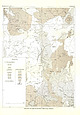 | | Journal (article/letter/editorial) | | some extent replaces hornblende. Ilmenite (or Magnetite): Crystals up to 2 mm. in size, the larger ones...associated with biotite. Zircon and ilmenite (or magnetite) are invariably present. Attanite occurs frequently...the crystallizing granite. Zircon and ilmenite (Magnetite?) are present in traces; allanite is less common...communication). .48 MnO. . Zircon and ilmenite (magnetite?) are erratically .22 MgO distributed. .19 CaO...makes a complete circle. The arcuate intrusion at Mount Megantic in southeast Quebec (McGerrigle, 1934) |  | | Book (edition) | | mmed at Broken Arrow aud Trout creek, in Sc. Clair county. The strata in this field are more faulted und...prong of Canoe creek, in St. Clair county, to Ha\sop creek, in Bibb county, a distance of 60 miles. Down to...to Helena, in Shelby county, the field has an average width of 5 or 6 miles. Below that point the width...miles being in the latitud" of Blocton, in Bibb county. The south ern end of this field has a greater...Jefferson county; Helena, Montevallo, and Brierfield, Shelby county; and at Blocion. Bibb county. The Warrior |  | | Report (issue) | | OCHER DEPOSITS, FREDERICK A. BURT 1 55 65 107 MOUNT MONADNOCK III VERMONT, J. E. Worr ........................................................... 10—Mount Monadnock, Vermont ...............................the primeval ocean appeared earlier in eastern New York than in the area that is now Vermont. Certainly...present it will suffice to mention Snake Mountain, Mount Philo and the cliffs at Red Rocks and Rock Point...the Green Mountains rock as old as any in the New York mountains, but if so it has long been covered by |  | | Report (volume) | | Louisiana........Prof. Gilbert D. Harris, Baton Rouge. Maine............Mr. C. Vey Holman, Bangor. Maryland....New Jersey...... .Dr. H. B. Kummel, Trenton. New York.........Mr. D. H. Newland, State Museum, Albany...See Bauxite and Hallpysite. Asbestos. Tallapoosa County, with corundum deposits near Dudleyville; not found...commercial quantity or quality. Asphalt. Colbert County, small quantity has been shipped from near Leighton;...following localities: Bibb County, Pratts Ferry; Calhoun County, near Tampa; Clay County, T. 20, Pv. 7 E.; Jefferson |  | | Report (issue) | | Mar. 3, 1917)...... . (B) The N e~ngton moraine, Maine, ' New Hampshire, and Massachusetts, by F Katz and...MapofNewEnglandcoastalregio~fromPlum Island, Mass., to Casco Bay, Maine, showing distribution of moraine and outwash deposits.... ·.... . 12 v. A, B, Gravel pit in Biddeford, Maine~ ..... ~ .........................................Moraine front and outwash, Merriland Ridge,. Wells, Maine .......... ~ ·. ; .......... . VII. South side of...of railroad cut across Merriland Ridge, Wells, Maine ........................... . 16· VIII. A, West |  | | Report (volume) | | .............................................. Maine.............................................................................................. New York. .................................................See Bauxite and Halloysite. Asbestos. Tallapoosa County, with corundum deposits near Dudleyville; not found...commercial quantity or quality. Asphalt. Colbert County, small quantity has been shipped from near Leighton;...following localities : Bibb County, Pratts Ferry; Calhoun County, near Tampa; Clay County, T. 20 S., R. 7 E.; |  | | Report (volume) | | October 1936. Ky., February 1930. La., March 1931. Maine, September 1935. Md., April 1929. Mass., April... 5 in., inch or inches. Circ., Circular. Co., County or Company. Indus., Industrial. Inst., Institute...tuffaceous facies called Aaron slate.] Abbeville-York zone. Pre-Cambrian : Northwestern South Carolina...mineral resources of S. C., pp. 6, 9, 12). Abbeville-York zone (Archean).—This area is very wide along its...equivalence, appears along upper limit of Abbeville-York zone interruptedly from E. side of Enoree River |  | | Report (volume) | | Bull. 1060-D, p. 193, 252-253, pl. 7. In Nemaha County, Kans., member is basal unit of Howard limestone...Aarde farm, sec. 4, T. 26 S., R. 11 E., Greenwood County. Aaron Slatet Precambrian or Paleozoic: Central...Central Railroad, sees. 5-7, T. 11 S., R. 5 E., Pope County. Named for Abbott Station. Abbyville Gabbrol Precambrian...map. Occurs in vicinity of Abbyville, Mecklenburg County. Abercrombie Formationl Middle Cambrian: Western...above Pope Creek coal. Named for Aberdeen, Butler County, Ky., where it stands out in prominent cliffs along |
|


