| Classification |
|---|
|
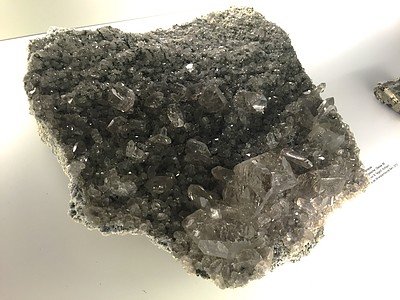
| Species: | Quartz var: Quartz Gwindel |
| Formula: | SiO2 |
| Confirmation |
|---|
|
| Validity: | Believed Valid |
| Associated Minerals Based on Photo Data: |
|---|
|
| Chlorite Group | ⓘ2 photos of Quartz Gwindel associated with Chlorite Group at this locality. |
| Smoky Quartz | ⓘ1 photo of Quartz Gwindel associated with Smoky Quartz at this locality. |
| Quartz | ⓘ1 photo of Quartz Gwindel associated with Quartz at this locality. |
| Data |
|---|
|
| Mineral Data: | Click here to view Quartz Gwindel data |
| Locality Data: | Click here to view Scheuchzerhorn, Oberaar glacier, Oberaar lake area, Guttannen, Interlaken-Oberhasli, Bern, Switzerland |
| Photo Gallery | View Gallery (7 photos) |
| Data Identifiers |
|---|
|
| Mindat Occurrence Record ID: | 938852 |
| Long-form Identifier: | 1:3:938852:9 |
| GUID (UUID V4): | c0bcb3a7-414b-4605-b4be-4b4a50c9096e |
| Nearest other occurrences of Quartz Gwindel |
|---|
|
|
| 2.1km (1.3 miles) | ⓘRufibach and Wenger cleft, Tierberge, Oberaar lake area, Guttannen, Interlaken-Oberhasli, Bern, Switzerland |
| 4.4km (2.7 miles) | ⓘFahner and Streun cleft, Zinggenstöcke, Oberaar lake area, Guttannen, Interlaken-Oberhasli, Bern, Switzerland |
| 18.9km (11.8 miles) | ⓘGalenstock, Tiefenbach, Realp, Urseren, Uri, Switzerland |
| 21.9km (13.6 miles) | ⓘWinterstock, Göscheneralp, Göschenen Valley, Göschenen, Reuss Valley, Uri, Switzerland |
| 23.1km (14.4 miles) | ⓘLochberg, Göscheneralp, Göschenen Valley, Göschenen, Reuss Valley, Uri, Switzerland |
| 25.2km (15.7 miles) | ⓘGöscheneralp, Göschenen Valley, Göschenen, Reuss Valley, Uri, Switzerland |
| 37.4km (23.2 miles) | ⓘRienzenstock, Rien Valley, Reuss Valley, Uri, Switzerland |
| 41.2km (25.6 miles) | ⓘCavradi gorge, Val Curnera, Tujetsch, Surselva Region, Grisons, Switzerland |
| 42.4km (26.3 miles) | ⓘVal Giuv, Tujetsch, Surselva Region, Grisons, Switzerland |
| 47.5km (29.5 miles) | ⓘDruntobel (Drun Tobel; Drun Sedrun; Krüzli valley; Kreuzli pass; Ruinas Plaunas), Sedrun, Tujetsch, Surselva Region, Grisons, Switzerland |
| References |
|---|
|
|


Scheuchzerhorn, Oberaar glacier, Oberaar lake area, Guttannen, Interlaken-Oberhasli, Bern, Switzerland