Home PageAbout MindatThe Mindat ManualHistory of MindatCopyright StatusWho We AreContact UsAdvertise on Mindat
Donate to MindatCorporate SponsorshipSponsor a PageSponsored PagesMindat AdvertisersAdvertise on Mindat
Learning CenterWhat is a mineral?The most common minerals on earthInformation for EducatorsMindat ArticlesThe ElementsThe Rock H. Currier Digital LibraryGeologic Time
Minerals by PropertiesMinerals by ChemistryAdvanced Locality SearchRandom MineralRandom LocalitySearch by minIDLocalities Near MeSearch ArticlesSearch GlossaryMore Search Options
The Mindat ManualAdd a New PhotoRate PhotosLocality Edit ReportCoordinate Completion ReportAdd Glossary Item
Mining CompaniesStatisticsUsersMineral MuseumsClubs & OrganizationsMineral Shows & EventsThe Mindat DirectoryDevice SettingsThe Mineral Quiz
Photo SearchPhoto GalleriesSearch by ColorNew Photos TodayNew Photos YesterdayMembers' Photo GalleriesPast Photo of the Day GalleryPhotography
╳Discussions
💬 Home🔎 Search📅 LatestGroups
EducationOpen discussion area.Fakes & FraudsOpen discussion area.Field CollectingOpen discussion area.FossilsOpen discussion area.Gems and GemologyOpen discussion area.GeneralOpen discussion area.How to ContributeOpen discussion area.Identity HelpOpen discussion area.Improving Mindat.orgOpen discussion area.LocalitiesOpen discussion area.Lost and Stolen SpecimensOpen discussion area.MarketplaceOpen discussion area.MeteoritesOpen discussion area.Mindat ProductsOpen discussion area.Mineral ExchangesOpen discussion area.Mineral PhotographyOpen discussion area.Mineral ShowsOpen discussion area.Mineralogical ClassificationOpen discussion area.Mineralogy CourseOpen discussion area.MineralsOpen discussion area.Minerals and MuseumsOpen discussion area.PhotosOpen discussion area.Techniques for CollectorsOpen discussion area.The Rock H. Currier Digital LibraryOpen discussion area.UV MineralsOpen discussion area.Recent Images in Discussions
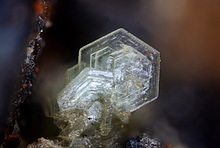


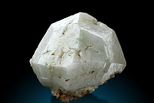


PhotosMillerite - Thompson Mine, Moab-Setting Lakes area, Thompson Nickel Belt, Manitoba, Canada

3rd Jul 2013 17:45 UTCRichard Gunter Expert


4th Jul 2013 19:53 UTCRob Woodside 🌟 Manager
4th Jul 2013 21:09 UTCRichard Gunter Expert
As far as I am aware all of the Thomson Mines, both underground and open pits, exploit a single ore body with essentially the same mineralogy. I do not know the exact location of the Thompson Mine Cubanite crystals but I assume they are from one of the underground mines in fractures in the sulphides. The massive sulphide ore will host all of the sulphide mineralogy except for a few of the late-stage veins that carried Millerite and Calcite-Pyrite into the overlying metasediments of the Thompson Formation. Therefore the Thompson Mines should be treated as one location with sub-locations, such as the 1A Pit for my Millerite, when the samples are personally collected.
Birchtree and Pipe II (the Pipe Pit is the main mine here, the underground Pipe Mine was not large) have very different geological settings and a different mineralogy than the Thompson Mine.
Richard Gunter

6th Jul 2013 00:13 UTCVik Vanrusselt Expert
I stumbled upon this thread about one of my specimens by chance but I'm glad I found it anyway :-)
Since English is not my first language, I'm having difficulty understanding whether or not there is an actual "T2 Pit" at the "Thompson Mine",
or just a "T2 portion of the Thompson Formation" (i.e. "NO, there is NO actual T2 Pit" and the wording on the label that came with the specimen is to be considered "wrong").
I've found another reference to a certain "T2 Zone" here: http://www.geologyontario.mndmf.gov.on.ca/gosportal/gos?command=mndmsearchdetails:mdi&uuid=MDI000000001218
Could someone please clear this up for me?
Thanks,
Vik
8th Jul 2013 18:22 UTCRichard Gunter Expert
Your reference has nothing to do with Thompson. It is an Province of Ontario website concerning deposits in their province. The Thompson, Birchtree and Pipe deposits are in the Province of Manitoba.
There probably is a T2 pit but it has nothing to do with the T2 portion of the Thompson Formation. Inco accessed the near-surface portions of the Thompson deposit with a number of small open pits. T1 and T1A were the only pits open when I visited but there were plans for more. The T2 pit was the next one to be opened as INCO numbered them geographically from the surface. They are all small pits and the bulk of the ore in Thomson is produced from underground workings. There is a T2 shaft at Thomson as well so it is easy to become confused. Millerite samples were found both in the open pits and underground. It appears from the matrix that your sample comes from the calcareous metasediments overlying the massive sulphides. Check my posted Millerite sample as it comes from the metasediments as well and the picture is too large to post here. Most of the Millerite from Thompson on the market comes from fractures in the massive sulphides.
Hope this helps.
Richard Gunter
8th Jul 2013 23:28 UTCVik Vanrusselt Expert
I will remove the link to the document from the caption to not complicate things further.
Vik
8th Jul 2013 23:32 UTCRichard Gunter Expert
Sounds good. Happy to be of help.


Mindat.org is an outreach project of the Hudson Institute of Mineralogy, a 501(c)(3) not-for-profit organization.
Copyright © mindat.org and the Hudson Institute of Mineralogy 1993-2024, except where stated. Most political location boundaries are © OpenStreetMap contributors. Mindat.org relies on the contributions of thousands of members and supporters. Founded in 2000 by Jolyon Ralph.
Privacy Policy - Terms & Conditions - Contact Us / DMCA issues - Report a bug/vulnerability Current server date and time: April 23, 2024 06:31:10