Home PageAbout MindatThe Mindat ManualHistory of MindatCopyright StatusWho We AreContact UsAdvertise on Mindat
Donate to MindatCorporate SponsorshipSponsor a PageSponsored PagesMindat AdvertisersAdvertise on Mindat
Learning CenterWhat is a mineral?The most common minerals on earthInformation for EducatorsMindat ArticlesThe ElementsThe Rock H. Currier Digital LibraryGeologic Time
Minerals by PropertiesMinerals by ChemistryAdvanced Locality SearchRandom MineralRandom LocalitySearch by minIDLocalities Near MeSearch ArticlesSearch GlossaryMore Search Options
The Mindat ManualAdd a New PhotoRate PhotosLocality Edit ReportCoordinate Completion ReportAdd Glossary Item
Mining CompaniesStatisticsUsersMineral MuseumsClubs & OrganizationsMineral Shows & EventsThe Mindat DirectoryDevice SettingsThe Mineral Quiz
Photo SearchPhoto GalleriesSearch by ColorNew Photos TodayNew Photos YesterdayMembers' Photo GalleriesPast Photo of the Day GalleryPhotography
╳Discussions
💬 Home🔎 Search📅 LatestGroups
EducationOpen discussion area.Fakes & FraudsOpen discussion area.Field CollectingOpen discussion area.FossilsOpen discussion area.Gems and GemologyOpen discussion area.GeneralOpen discussion area.How to ContributeOpen discussion area.Identity HelpOpen discussion area.Improving Mindat.orgOpen discussion area.LocalitiesOpen discussion area.Lost and Stolen SpecimensOpen discussion area.MarketplaceOpen discussion area.MeteoritesOpen discussion area.Mindat ProductsOpen discussion area.Mineral ExchangesOpen discussion area.Mineral PhotographyOpen discussion area.Mineral ShowsOpen discussion area.Mineralogical ClassificationOpen discussion area.Mineralogy CourseOpen discussion area.MineralsOpen discussion area.Minerals and MuseumsOpen discussion area.PhotosOpen discussion area.Techniques for CollectorsOpen discussion area.The Rock H. Currier Digital LibraryOpen discussion area.UV MineralsOpen discussion area.Recent Images in Discussions


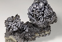


Improving Mindat.orgGraphite ball from the Saranac mine?
24th Dec 2014 20:28 UTCReiner Mielke Expert
24th Dec 2014 21:29 UTCReiner Mielke Expert

25th Dec 2014 00:46 UTCMatt Neuzil Expert
25th Dec 2014 15:28 UTCJohn R. Montgomery 🌟 Expert
I will get in touch with Michael... just wrote him about another matter on this Christmas morn and I know he is with family so it may be a while before i get back with an answer .
thanks
John

25th Dec 2014 18:24 UTCKelly Nash 🌟 Expert
25th Dec 2014 21:51 UTCReiner Mielke Expert
26th Dec 2014 00:17 UTCMichael J. Bainbridge Expert
26th Dec 2014 01:35 UTCJohn R. Montgomery 🌟 Expert
26th Dec 2014 12:45 UTCReiner Mielke Expert
While on this Saranac subject, I don't know why it is called a mine? It never got beyond the prospect pit stage nor produced anything so it is not technically a mine. What do you think about changing it to "property" or should we just leave it as is to match what Sabina calls it?
26th Dec 2014 14:10 UTCMatt Neuzil Expert
26th Dec 2014 20:14 UTCReiner Mielke Expert
26th Dec 2014 21:43 UTCMichael J. Bainbridge Expert
"The showings were explored for radioactive minerals by several open cuts from 1954-1956. The work was conducted by Saranac Uranium Mines Limited. At the Zircon showing, granite and granite pegmatite are exposed by a 46-m long open-cut and by a trench 30 m to the south. A skarn in crystalline limestone is exposed by two trenches 90 m north of the open-cut. The Pegmatite showing is exposed by an open-cut 46 m long.
To reach the Zircon showing, proceed onto the road that leaves Highway 121 at km 24.2 and continue beyond the garbage disposal area along a single-lane road for about 350 m to the open-cut. The trenches exposing the skarn are along this road. To reach the Pegmatite showing, proceed along the Hadlington Road for 2.45 km from Highway 121; turn left and proceed lOO m to the open-cut which is 9 m above the level of the swamp (on the east side of the opening). The junction of the Hadlington Road is at km 23.3."
I never actually made it as far as the zircon showing, but according to the description, it is only 90m from the trench where I found the graphite. The pegmatite showing, on the other hand, is 1.7km away from the zircon showing (meaning they would be on different lots):
"The property consists of two deposits, the Zircon and the Pegmatite showings which are l. 7 km apart."
Additionally, the pegmatite and zircon showings are accessed by different roads. To me, this means that the pegmatite and zircon showings should be different localities in Monmouth Tp., with the workings in the skarn being a sub-locality to the zircon showing.
27th Dec 2014 02:33 UTCReiner Mielke Expert


Mindat.org is an outreach project of the Hudson Institute of Mineralogy, a 501(c)(3) not-for-profit organization.
Copyright © mindat.org and the Hudson Institute of Mineralogy 1993-2024, except where stated. Most political location boundaries are © OpenStreetMap contributors. Mindat.org relies on the contributions of thousands of members and supporters. Founded in 2000 by Jolyon Ralph.
Privacy Policy - Terms & Conditions - Contact Us / DMCA issues - Report a bug/vulnerability Current server date and time: April 20, 2024 01:49:23