| Locality | Latitude | Longitude | Distance | Bearing |
|---|
| Braens Quarry, North Haledon, Passaic County, New Jersey, USA | 40° 57' 15" N | 74° 10' 17" W | 0.0km (0.0 miles) | |
| Prospect Park Quarry, Prospect Park, Passaic County, New Jersey, USA | 40° 56' 29" N | 74° 10' 32" W | 1.5km (0.9 miles) | |
| Hinchcliffe Stadium, Paterson, Passaic County, New Jersey, USA | 40° 55' 5" N | 74° 10' 51" W | 4.1km (2.5 miles) | |
| Hoxie's Quarry, Paterson, Passaic County, New Jersey, USA | 40° 55' 0" N | 74° 10' 0" W | 4.2km (2.6 miles) | |
| Philip Kramer Quarry, Paterson, Passaic County, New Jersey, USA | 40° 55' 0" N | 74° 10' 0" W | 4.2km (2.6 miles) | |
| Interstate 80 roadcut, Paterson, Passaic County, New Jersey, USA | 40° 55' 0" N | 74° 10' 0" W | 4.2km (2.6 miles) | |
| Ryle Avenue Quarry, Paterson, Passaic County, New Jersey, USA | 40° 55' 0" N | 74° 10' 0" W | 4.2km (2.6 miles) | |
| McKiernan & Bergin Quarry, Paterson, Passaic County, New Jersey, USA | 40° 55' 0" N | 74° 10' 0" W | 4.2km (2.6 miles) | |
| Passaic Falls, Paterson, Passaic County, New Jersey, USA | 40° 54' 57" N | 74° 10' 54" W | 4.3km (2.7 miles) | |
| Garret Street condominium construction site, Paterson, Passaic County, New Jersey, USA | 40° 54' 20" N | 74° 10' 50" W | 5.4km (3.4 miles) | |
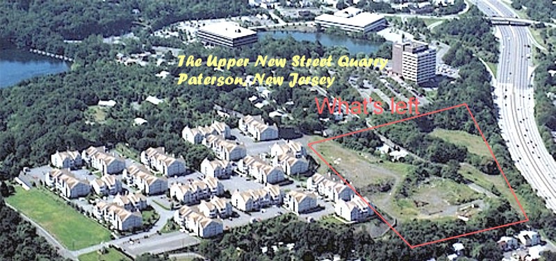
| Upper New Street Quarry, Paterson, Passaic County, New Jersey, USA | 40° 54' 20" N | 74° 11' 6" W | 5.5km (3.4 miles) | |
| Lower New Street Quarry, Paterson, Passaic County, New Jersey, USA | 40° 54' 18" N | 74° 11' 14" W | 5.6km (3.5 miles) | |
| Garrett Rock, Woodland Park, Passaic County, New Jersey, USA | 40° 54' 4" N | 74° 10' 40" W | 5.9km (3.7 miles) | |
| Riverside Quarry, Woodland Park, Passaic County, New Jersey, USA | 40° 53' 59" N | 74° 12' 0" W | 6.5km (4.0 miles) | |
| Preakness Quarry, Woodland Park, Passaic County, New Jersey, USA | 40° 53' 59" N | 74° 12' 0" W | 6.5km (4.0 miles) | |
| Albion Place, Clifton, Passaic County, New Jersey, USA | 40° 53' 28" N | 74° 10' 32" W | 7.0km (4.4 miles) | |
| McBride Avenue & Browertown Road pumping station, Woodland Park, Passaic County, New Jersey, USA | 40° 53' 36" N | 74° 12' 6" W | 7.2km (4.5 miles) | |
| W.A. Ferguson Quarry, Albion Place, Clifton, Passaic County, New Jersey, USA | 40° 52' 59" N | 74° 10' 0" W | 7.9km (4.9 miles) | |
| Union Building and Construction Quarry, Woodland Park, Passaic County, New Jersey, USA | 40° 52' 37" N | 74° 11' 17" W | 8.7km (5.4 miles) | |
| Boston mine, Orange County, New York, USA | 41° 1' 48" N | 74° 8' 44" W | 8.7km (5.4 miles) | |
| East Jersey Water Company Reservoir, Woodland Park, Passaic County, New Jersey, USA | 40° 52' 38" N | 74° 11' 34" W | 8.7km (5.4 miles) | |
| Mountain View, Wayne Township, Passaic County, New Jersey, USA | 40° 55' 0" N | 74° 16' 0" W | 9.0km (5.6 miles) | |
| Great Notch, Little Falls Township, Passaic County, New Jersey, USA | 40° 52' 28" N | 74° 12' 27" W | 9.4km (5.8 miles) | |
| Richfield, Clifton, Passaic County, New Jersey, USA | 40° 52' 8" N | 74° 10' 21" W | 9.5km (5.9 miles) | |
| Great Notch Corp. Quarry, Great Notch, Little Falls Township, Passaic County, New Jersey, USA | 40° 52' 14" N | 74° 12' 0" W | 9.6km (6.0 miles) | |
| Houdaille Quarry, Little Falls Township, Passaic County, New Jersey, USA | 40° 52' 10" N | 74° 11' 47" W | 9.6km (6.0 miles) | |
| Francisco Brothers Quarry, Great Notch, Little Falls Township, Passaic County, New Jersey, USA | 40° 52' 18" N | 74° 12' 28" W | 9.6km (6.0 miles) | |
| Union Building and Construction Co. Quarry, Richfield, Clifton, Passaic County, New Jersey, USA | 40° 52' 0" N | 74° 10' 0" W | 9.7km (6.1 miles) | |
| Pompton Township, Wayne Township, Passaic County, New Jersey, USA | 40° 59' 27" N | 74° 16' 44" W | 9.9km (6.2 miles) | |
| Little Falls, Little Falls Township, Passaic County, New Jersey, USA | 40° 52' 7" N | 74° 12' 31" W | 10.0km (6.2 miles) | |


Boston mine, Orange County, New York, USA