| Locality | Latitude | Longitude | Distance | Bearing |
|---|
| Dolyhir Quarry, Old Radnor, Powys, Wales, UK | 52° 12' 59" N | 3° 6' 34" W | 0.0km (0.0 miles) | |
| Strinds Quarry, Old Radnor, Powys, Wales, UK | 52° 12' 52" N | 3° 6' 39" W | 0.2km (0.1 miles) | |
| Gore Quarry, Walton, Old Radnor, Powys, Wales, UK | 52° 13' 29" N | 3° 5' 31" W | 1.5km (0.9 miles) | |
| Walton, Old Radnor, Powys, Wales, UK | 52° 13' 51" N | 3° 5' 25" W | 2.1km (1.3 miles) | |
| Folly Park Colliery, Powys, Wales, UK | 52° 15' 55" N | 3° 0' 13" W | 9.0km (5.6 miles) | |
| Upper Gilwern Quarry, Howey, Llandrindod Wells, Powys, Wales, UK | 52° 12' 51" N | 3° 19' 52" W | 15.1km (9.4 miles) | |
| Llanelwedd Quarry, Builth Wells, Powys, Wales, UK | 52° 9' 30" N | 3° 23' 14" W | 20.0km (12.4 miles) | |
| Rhiw goch Colliery, Powys, Wales, UK | 52° 18' 2" N | 3° 23' 5" W | 20.9km (13.0 miles) | |
| Leinthall Quarry, Aymestrey, Herefordshire, England, UK | 52° 18' 43" N | 2° 48' 46" W | 22.8km (14.2 miles) | |
| Talachddu Mine, Talachddu, Felin-fach (Felinfach), Powys, Wales, UK | 51° 59' 53" N | 3° 19' 58" W | 28.7km (17.8 miles) | |
| Black Noll Mine, Myndtown, Shropshire, England, UK | 52° 29' 35" N | 2° 53' 54" W | 34.0km (21.1 miles) | |
| Cwm Elan Mine, Rhayader, Powys, Wales, UK | 52° 16' 22" N | 3° 36' 49" W | 34.9km (21.7 miles) | |
| Nant Paradwys, Rhayader, Powys, Wales, UK | 52° 13' 43" N | 3° 37' 26" W | 35.1km (21.8 miles) | |
| Rhiw Nant Mine, Rhiw Nant, Powys, Wales, UK | 52° 14' 34" N | 3° 37' 27" W | 35.2km (21.9 miles) | |
| Cwm Fron Mine, Llanidloes, Powys, Wales, UK | 52° 24' 55" N | 3° 30' 51" W | 35.3km (21.9 miles) | |
| Rhiwnant Mine, Rhayader, Powys, Wales, UK | 52° 14' 35" N | 3° 37' 34" W | 35.3km (21.9 miles) | |
| Newchapel Mine, Llanidloes, Powys, Wales, UK | 52° 26' 1" N | 3° 29' 23" W | 35.4km (22.0 miles) | |
| Dalrhiw, Rhayader, Powys, Wales, UK | 52° 13' 26" N | 3° 37' 57" W | 35.6km (22.1 miles) | |
| Haytons Bent Mine, Ludlow, Shropshire, England, UK | 52° 25' 35" N | 2° 42' 47" W | 35.7km (22.2 miles) | |
| Haytons Bent Mine, Culmington, Ludlow, Shropshire, England, UK | 52° 25' 35" N | 2° 42' 47" W | 35.7km (22.2 miles) | |
| Dolwen Mine, Llanidloes, Powys, Wales, UK | 52° 26' 44" N | 3° 28' 37" W | 35.7km (22.2 miles) | |
| Nant-y-Car Mine, Rhayader, Powys, Wales, UK | 52° 14' 1" N | 3° 37' 58" W | 35.7km (22.2 miles) | |
| South Nant-y-Car Mine, Rhayader, Powys, Wales, UK | 52° 13' 54" N | 3° 38' 3" W | 35.8km (22.2 miles) | |
| Tylwch United Mine, Llanidloes, Powys, Wales, UK | 52° 24' 48" N | 3° 31' 39" W | 35.9km (22.3 miles) | |
| More Quarry (Squilver Quarry), Disgwylfa Hill, Moreswood, Hope-Shelve District, Shropshire, England, UK | 52° 31' 58" N | 2° 59' 42" W | 36.1km (22.4 miles) | |
| Disgwylfa Hill, Moreswood, Hope-Shelve District, Shropshire, England, UK | 52° 31' 58" N | 2° 59' 42" W | 36.1km (22.4 miles) | |
| Heath Mynd, Moreswood, Hope-Shelve District, Shropshire, England, UK | 52° 32' 2" N | 2° 58' 55" W | 36.4km (22.6 miles) | |
| Gorn Mine, Llanidloes, Powys, Wales, UK | 52° 26' 35" N | 3° 29' 57" W | 36.6km (22.7 miles) | |
| Nant-y-Garw Mine, Rhayader, Powys, Wales, UK | 52° 13' 56" N | 3° 38' 58" W | 36.8km (22.9 miles) | |
| Pultheley Mine, Pultheley, Shropshire, England, UK | 52° 32' 37" N | 2° 59' 33" W | 37.3km (23.2 miles) | |
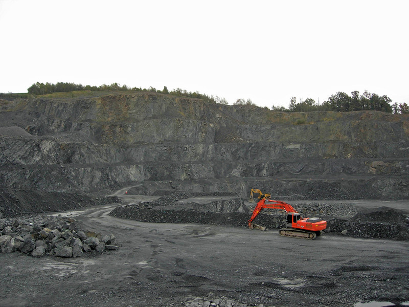


Dolyhir Quarry, Old Radnor, Powys, Wales, UK