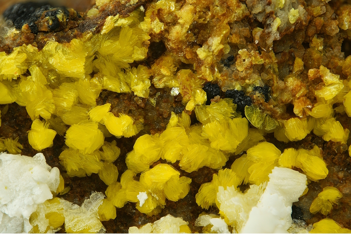
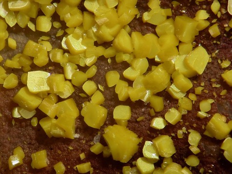
Carnotite
A valid IMA mineral species - grandfathered
This page is currently not sponsored. Click here to sponsor this page.


About Carnotite
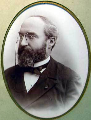
Marie-Adolphe Carnot
Formula:
K2(UO2)2(VO4)2 · 3H2O
Colour:
Bright yellow, yellow, greenish yellow
Lustre:
Sub-Vitreous, Resinous, Waxy, Silky, Dull, Earthy
Hardness:
2
Specific Gravity:
4.70
Crystal System:
Monoclinic
Member of:
Name:
Named in 1899 by Charles Friedel and Édouard Cumenge in honor of Marie-Adolphe Carnot [January 27, 1839 Paris, France - June 20, 1920], French mining engineer and chemist, professor at École des Mines and, later Chief Engineer of Mines and Inspector General of Mines, becoming Dean of the Ecole Nationale des Mines in 1901-1907, when he retired. The unrelated mineral silicocarnotite is also named after him.
Carnotite Group.
A secondary mineral resulting from the alteration of Uraninite, Montroseite, or Davidite. Occurs in sandstones, especially in paleochannels, near fossil carbonaceous matter, in calcretes and near playas.
Chemically close to vandermeerscheite.
A secondary mineral resulting from the alteration of Uraninite, Montroseite, or Davidite. Occurs in sandstones, especially in paleochannels, near fossil carbonaceous matter, in calcretes and near playas.
Chemically close to vandermeerscheite.
Unique Identifiers
Mindat ID:
907
Long-form identifier:
mindat:1:1:907:0
GUID
(UUID V4):
(UUID V4):
e3503ccc-7e21-416c-9d19-19704bd10426
IMA Classification of Carnotite
Approved, 'Grandfathered' (first described prior to 1959)
First published:
1899
Classification of Carnotite
4.HB.05
4 : OXIDES (Hydroxides, V[5,6] vanadates, arsenites, antimonites, bismuthites, sulfites, selenites, tellurites, iodates)
H : V[5,6] Vanadates
B : Uranyl Sorovanodates
4 : OXIDES (Hydroxides, V[5,6] vanadates, arsenites, antimonites, bismuthites, sulfites, selenites, tellurites, iodates)
H : V[5,6] Vanadates
B : Uranyl Sorovanodates
40.2a.28.1
40 : HYDRATED NORMAL PHOSPHATES,ARSENATES AND VANADATES
2a : AB2(XO4)2·xH2O, containing (UO2)2+
40 : HYDRATED NORMAL PHOSPHATES,ARSENATES AND VANADATES
2a : AB2(XO4)2·xH2O, containing (UO2)2+
21.4.4
21 : Vanadates (and vanadates with arsenate or phosphate)
4 : Vanadates of U, Mn, Fe or Ni
21 : Vanadates (and vanadates with arsenate or phosphate)
4 : Vanadates of U, Mn, Fe or Ni
Mineral Symbols
As of 2021 there are now IMA–CNMNC approved mineral symbols (abbreviations) for each mineral species, useful for tables and diagrams.
Please only use the official IMA–CNMNC symbol. Older variants are listed for historical use only.
Please only use the official IMA–CNMNC symbol. Older variants are listed for historical use only.
| Symbol | Source | Reference |
|---|---|---|
| Cnt | IMA–CNMNC | Warr, L.N. (2021). IMA–CNMNC approved mineral symbols. Mineralogical Magazine, 85(3), 291-320. doi:10.1180/mgm.2021.43 |
| Cnt | The Canadian Mineralogist (2019) | The Canadian Mineralogist (2019) The Canadian Mineralogist list of symbols for rock- and ore-forming minerals (December 30, 2019). download |
Physical Properties of Carnotite
Sub-Vitreous, Resinous, Waxy, Silky, Dull, Earthy
Transparency:
Translucent
Comment:
Silky to waxy when crystalline
Colour:
Bright yellow, yellow, greenish yellow
Comment:
Easily stained when fine-grained
Streak:
Strontian-yellow
Hardness:
2 on Mohs scale
Tenacity:
Fragile
Cleavage:
Perfect
on {001}, perfect, micaceous
on {001}, perfect, micaceous
Fracture:
Micaceous
Density:
4.70 g/cm3 (Measured) 4.91 g/cm3 (Calculated)
Comment:
Earthy material lower in compactness
Optical Data of Carnotite
Type:
Biaxial (-)
RI values:
nα = 1.750 nβ = 1.925 nγ = 1.950
2V:
Measured: 43° to 60°, Calculated: 26° to 36°
Birefringence:
0.200
Max Birefringence:
δ = 0.200

Image shows birefringence interference colour range (at 30µm thickness)
and does not take into account mineral colouration.
and does not take into account mineral colouration.
Surface Relief:
Very High
Dispersion:
r < v
Optical Extinction:
Z^a ~14°; X=c, Y=b
Pleochroism:
Weak
Comments:
X = Nearly colourless to pale grayish yellow
Y = Z = Canary yellow, lemon-yellow
Y = Z = Canary yellow, lemon-yellow
Comments:
Indices of refraction increase as water content decreases.
Chemistry of Carnotite
Mindat Formula:
K2(UO2)2(VO4)2 · 3H2O
Crystallography of Carnotite
Crystal System:
Monoclinic
Class (H-M):
2/m - Prismatic
Space Group:
P21/b
Setting:
P21/a
Cell Parameters:
a = 10.47 Å, b = 8.41 Å, c = 6.91 Å
β = 103.83°
β = 103.83°
Ratio:
a:b:c = 1.245 : 1 : 0.822
Unit Cell V:
590.80 ų (Calculated from Unit Cell)
Z:
2
Morphology:
Crystals rare, diamond-shaped, flattened {001} and rhomboidal {110}, also lath-like [010] with {100} and {110} or {120}; (110) ^ (110) ~78°; commonly as fine aggregates or powdery; disseminated, compact massive.
Twinning:
On {001} as both the composition and twin plane.
Comment:
Space group determined based on synthetic, anhydrous material.
Crystal Structure
Load
Unit Cell | Unit Cell Packed
2x2x2 | 3x3x3 | 4x4x4
Unit Cell | Unit Cell Packed
2x2x2 | 3x3x3 | 4x4x4
Show
Big Balls | Small Balls | Just Balls | Spacefill
Polyhedra Off | Si Polyhedra | All Polyhedra
Remove metal-metal sticks
Big Balls | Small Balls | Just Balls | Spacefill
Polyhedra Off | Si Polyhedra | All Polyhedra
Remove metal-metal sticks
Display Options
Black Background | White Background
Perspective On | Perspective Off
2D | Stereo | Red-Blue | Red-Cyan
Black Background | White Background
Perspective On | Perspective Off
2D | Stereo | Red-Blue | Red-Cyan
View
CIF File Best | x | y | z | a | b | c
CIF File Best | x | y | z | a | b | c
Rotation
Stop | Start
Stop | Start
Labels
Console Off | On | Grey | Yellow
Console Off | On | Grey | Yellow
Data courtesy of the American Mineralogist Crystal Structure Database. Click on an AMCSD ID to view structure
| ID | Species | Reference | Link | Year | Locality | Pressure (GPa) | Temp (K) |
|---|---|---|---|---|---|---|---|
| 0012038 | Carnotite | Sundberg I, Sillen L G (1949) On the crystal structure of KUO2VO4 (synthetic anhydrous carnotite) Arkiv for Kemi 1 337-351 | 1949 | synthetic | 0 | 293 |
CIF Raw Data - click here to close
X-Ray Powder Diffraction
Powder Diffraction Data:
| d-spacing | Intensity |
|---|---|
| 6.56 Å | (100) |
| 4.25 Å | (30) |
| 3.53 Å | (50) |
| 3.25 Å | (30) |
| 3.12 Å | (70) |
| 2.571 Å | (20) |
| 2.156 Å | (30) |
Geological Environment
Paragenetic Mode(s):
| Paragenetic Mode | Earliest Age (Ga) |
|---|---|
| Stage 7: Great Oxidation Event | <2.4 |
| 47a : [Near-surface hydration of prior minerals] | |
| Stage 10a: Neoproterozoic oxygenation/terrestrial biosphere | <0.6 |
| 53 : Other minerals with taphonomic origins | <0.4 |
Geological Setting:
Colorado Plateau type uranium deposits, near playas.
Type Occurrence of Carnotite
General Appearance of Type Material:
Yellow powder and powdery masses
Place of Conservation of Type Material:
University of Colorado, Boulder, Colorado: #2218. Harvard University, Cambridge, Massachusetts, USA: #106253.
Geological Setting of Type Material:
Colorado Plateau sedimentary vanadium-uranium deposits
Reference:
Friedel, C., Cumenge, E. (1899) Sur un nouveau minerai d´urane. Bulletin de la Société Française de Minéralogie: 22: 26-29.
Synonyms of Carnotite
Other Language Names for Carnotite
Varieties of Carnotite
| Thallium-bearing Carnotite | Thallium-bearing variety of Carnotite. |
Relationship of Carnotite to other Species
Member of:
Other Members of this group:
| Margaritasite | (Cs,K,H3O)2(UO2)2(VO4)2 · H2O | Mon. 2/m : P21/b |
| Metatyuyamunite | Ca(UO2)2(VO4)2 · 3H2O | Orth. mmm (2/m 2/m 2/m) |
| Metavanuralite | Al(UO2)2(VO4)2(OH) · 8H2O | Tric. |
| Sengierite | Cu2(UO2)2(VO4)2 · 6H2O | Mon. 2/m : P21/b |
| Strelkinite | Na2(UO2)2(VO4)2 · 6H2O | Orth. |
| Tyuyamunite | Ca(UO2)2(VO4)2 · 5-8H2O | Orth. mmm (2/m 2/m 2/m) : Pnna |
| Vanuralite | Al(UO2)2(V2O8)(OH) · 11H2O | Mon. 2/m |
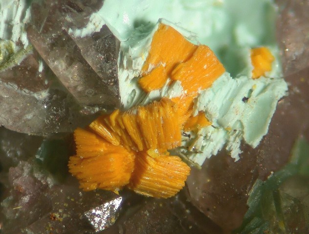
Common Associates
Associated Minerals Based on Photo Data:
| 19 photos of Carnotite associated with Uraninite | UO2 |
| 17 photos of Carnotite associated with Chalcedony | SiO2 |
| 15 photos of Carnotite associated with Chrysocolla | Cu2-xAlx(H2-xSi2O5)(OH)4 · nH2O, x < 1 |
| 14 photos of Carnotite associated with Tyuyamunite | Ca(UO2)2(VO4)2 · 5-8H2O |
| 14 photos of Carnotite associated with Weeksite | K2(UO2)2(Si5O13) · 4H2O |
| 9 photos of Carnotite associated with Davidite-(La) | La(Y,U)Fe2(Ti,Fe,Cr,V)18(O,OH,F)38 |
| 9 photos of Carnotite associated with Malachite | Cu2(CO3)(OH)2 |
| 7 photos of Carnotite associated with Chalcopyrite | CuFeS2 |
| 7 photos of Carnotite associated with Zippeite | K3(UO2)4(SO4)2O3(OH) · 3H2O |
| 5 photos of Carnotite associated with Metatyuyamunite | Ca(UO2)2(VO4)2 · 3H2O |
Related Minerals - Strunz-mindat Grouping
| 4.HB.05 | Margaritasite | (Cs,K,H3O)2(UO2)2(VO4)2 · H2O |
| 4.HB.10 | Sengierite | Cu2(UO2)2(VO4)2 · 6H2O |
| 4.HB.15 | Curienite | Pb(UO2)2(VO4)2 · 5H2O |
| 4.HB.15 | Francevillite | Ba(UO2)2(VO4)2 · 5H2O |
| 4.HB.15 | Fritzscheite | Mn(UO2)2(PO4,VO4)2 · 10H2O (?) |
| 4.HB.15 | Finchite | Sr(UO2)2(V2O8) · 5H2O |
| 4.HB.20 | Metavanuralite | Al(UO2)2(VO4)2(OH) · 8H2O |
| 4.HB.20 | Vanuralite | Al(UO2)2(V2O8)(OH) · 11H2O |
| 4.HB.25 | Metatyuyamunite | Ca(UO2)2(VO4)2 · 3H2O |
| 4.HB.25 | Tyuyamunite | Ca(UO2)2(VO4)2 · 5-8H2O |
| 4.HB.30 | Strelkinite | Na2(UO2)2(VO4)2 · 6H2O |
| 4.HB.35 | Uvanite | U6+2V5+6O21 · 15H2O (?) |
| 4.HB.40 | Rauvite | Ca(UO2)2(V10O28) · 16H2O |
| 4.HB.45 | Vandermeerscheite | K2[(UO2)2V2O8] · 2H2O |
Fluorescence of Carnotite
Not Fluorescent
Other Information
Notes:
Radioactive. Water content is partly zeolitic and varies with humidity at ambient temperatures. Readily soluble in acids.
Health Risks:
Contains uranium - always wash hands after handling. Avoid inhaling dust when handling or breaking. Never lick or ingest. Avoid prolonged exposure in proximity of the body. Store away from inhabited areas.
Industrial Uses:
Uranium ore
Internet Links for Carnotite
mindat.org URL:
https://www.mindat.org/min-907.html
Please feel free to link to this page.
Please feel free to link to this page.
Search Engines:
External Links:
Mineral Dealers:
References for Carnotite
Reference List:
Localities for Carnotite
 symbol to view information about a locality.
The
symbol to view information about a locality.
The Locality List
 - This locality has map coordinates listed.
- This locality has estimated coordinates.
ⓘ - Click for references and further information on this occurrence.
? - Indicates mineral may be doubtful at this locality.
- This locality has map coordinates listed.
- This locality has estimated coordinates.
ⓘ - Click for references and further information on this occurrence.
? - Indicates mineral may be doubtful at this locality.
 - Good crystals or important locality for species.
 - World class for species or very significant.
(TL) - Type Locality for a valid mineral species.
(FRL) - First Recorded Locality for everything else (eg varieties).
- World class for species or very significant.
(TL) - Type Locality for a valid mineral species.
(FRL) - First Recorded Locality for everything else (eg varieties).
All localities listed without proper references should be considered as questionable.
Argentina | |
| |
| |
| |
| |
| |
| |
| |
| |
| |
| |
| |
| |
| |
| |
| |
| |
| |
| |
Australia | |
| |
| |
| |
| |
| |
| |
| |
| |
| |
| |
| |
| |
| |
| |
| |
| |
| |
Canada | |
| |
| |
| |
| |
| |
| |
Chile | |
| |
China | |
| |
Czech Republic | |
| |
| |
| |
| |
| |
DR Congo | |
| |
Egypt | |
| |
| |
| |
France | |
| |
| |
| |
| |
| |
| |
Gabon | |
| |
Germany | |
| |
| |
| |
| |
| |
| |
| |
| |
| |
| |
Hungary | |
| |
India | |
| |
| |
Iraq | |
| |
Israel | |
| |
Italy | |
| |
| |
| |
Japan | |
| |
| |
Jordan | |
| |
Kazakhstan | |
| |
| |
Kyrgyzstan | |
| |
| |
Madagascar | |
| |
| |
Mauritania | |
| |
| |
| |
Mexico | |
| |
| |
| |
Middle East | |
Morocco | |
| |
| |
| |
Namibia | |
| |
| |
| |
Niger | |
| |
| |
| |
Norway | |
| |
| |
Pakistan | |
| |
Portugal | |
| |
Russia | |
| |
| |
| |
| |
| |
South Africa | |
| |
Spain | |
| |
| |
Switzerland | |
| |
| |
UK | |
| |
| |
Ukraine | |
| |
USA | |
| |
| |
| |
| |
| |
| |
| |
| |
| |
| |
| |
| |
| |
| |
| |
| |
| |
| |
| |
| |
| |
| |
| |
| |
| |
| |
| |
| |
| |
| |
| |
| |
| |
| |
| |
| |
| |
| |
| |
| |
| |
| |
| |
| |
| |
| |
| |
| |
| |
| |
| |
| |
| |
| |
| |
| |
| |
| |
| |
| |
| |
| |
| |
| |
| |
| |
| |
| |
| |
| |
| |
| |
| |
| |
| |
| |
| |
| |
| |
| |
| |
| |
| |
| |
| |
| |
| |
| |
| |
| |
| |
| |
| |
| |
| |
| |
| |
| |
| |
| |
| |
| |
| |
| |
| |
| |
| |
| |
| |
| |
| |
| |
| |
| |
| |
| |
| |
| |
| |
| |
| |
| |
| |
| |
Arthur L. Flagg (1883-1961) Collection #1686Identification: Dealer/Collection Label | |
| |
| |
| |
| |
| |
| |
| |
| |
| |
| |
| |
| |
| |
| |
| |
| |
| |
| |
| |
| |
| |
| |
| |
| |
| |
| |
| |
| |
| |
| |
| |
| |
| |
| |
| |
| |
| |
| |
| |
| |
| |
| |
| |
| |
| |
| |
| |
| |
| |
| |
| |
| |
| |
| |
| |
| |
| |
| |
| |
| |
| |
| |
| |
| |
| |
| |
| |
| |
| |
| |
| |
| |
| |
| |
| |
| |
| |
| |
| |
| |
| |
| |
| |
| |
| |
| |
| |
| |
| |
| |
| |
| |
| |
| |
| |
| |
| |
| |
| |
| |
| |
| |
| |
| |
| |
| |
| |
| |
| |
| |
| |
| |
| |
| |
| |
| |
| |
| |
| |
| |
| |
| |
| |
| |
| |
| |
| |
| |
| |
| |
| |
| |
| |
| |
| |
| |
| |
| |
| |
| |
| |
| |
| |
| |
| |
| |
| |
| |
| |
| |
Kampf, Anthony R., Hughes, John M., Nash, Barbara P., Marty, Joe (2019) Pandoraite-Ba and pandoraite-Ca, Ba(V4+5V5+2)O16·3H2O and Ca(V4+5V5+2)O16·3H2O, two new vanadium oxide bronze minerals in solid solution from the Pandora Mine, La Sal Mining District, San Juan County, Colorado, USA. The Canadian Mineralogist, 57 (2) 255-265 doi:10.3749/canmin.1800063 | |
| |
| |
| |
| |
| |
| |
| |
| |
| |
| |
| |
| |
| |
| |
| |
| |
| |
| |
| |
| |
| |
| |
| |
| |
| |
| |
| |
| |
| |
| |
| |
| |
| |
| |
| |
| |
| |
| |
| |
| |
| |
| |
| |
| |
| |
Uzbekistan | |
| |
Zimbabwe | |
|


Quick NavTopAbout CarnotiteUnique IdentifiersIMA Classification Classification Mineral SymbolsPhysical Properties Optical Data Chemistry Crystallography Crystal StructureX-Ray Powder DiffractionGeological EnvironmentType Occurrence SynonymsOther LanguagesVarietiesRelationshipsCommon AssociatesStrunz-MindatFluorescence Other InformationInternet Links References Localities Locality List


Monument Valley Mining District, San Juan County, Utah, USA