| Locality | Latitude | Longitude | Distance | Bearing |
|---|
| Silver Bell prospect (Silver Bell Mine), Red Mountain [town] (Osdick), Rand Mining District (Randsburg Mining District), San Bernardino County, California, USA | 35° 21' 0" N | 117° 37' 40" W | 0.0km (0.0 miles) | |
| Silver Moon prospect (Silver Moon Mine), Red Mountain [town] (Osdick), Rand Mining District (Randsburg Mining District), San Bernardino County, California, USA | 35° 21' 8" N | 117° 37' 45" W | 0.3km (0.2 miles) | |
| Ben Hur Gold Wash Mine (Gold Wash Mine), Randsburg, Rand District (Randsburg District), Rand Mountains, Kern County, California, USA | 35° 21' 1" N | 117° 37' 52" W | 0.3km (0.2 miles) | |
| Unnamed U claim [42], Red Mountain [town] (Osdick), Rand Mining District (Randsburg Mining District), San Bernardino County, California, USA | 35° 20' 50" N | 117° 37' 49" W | 0.4km (0.2 miles) | |
| Belcher Extension Mine (Belcher Extension prospect), Red Mountain [town] (Osdick), Rand Mining District (Randsburg Mining District), San Bernardino County, California, USA | 35° 20' 48" N | 117° 37' 42" W | 0.4km (0.2 miles) | |
| Gold Wash Mine (Ben Hur), Randsburg, Rand District (Randsburg District), Rand Mountains, Kern County, California, USA | 35° 20' 54" N | 117° 37' 54" W | 0.4km (0.2 miles) | |
| Kelly Rand Extension prospect, Red Mountain [town] (Osdick), Rand Mining District (Randsburg Mining District), San Bernardino County, California, USA | 35° 21' 11" N | 117° 37' 47" W | 0.4km (0.2 miles) | |
| Bray and Bisbee prospect (Bray and Bisbee Mine), Red Mountain [town] (Osdick), Rand Mining District (Randsburg Mining District), San Bernardino County, California, USA | 35° 20' 54" N | 117° 37' 24" W | 0.4km (0.3 miles) | |
| Mispah-Montana claims (Montana Fraction claim; Mispah Extension claim), Johannesburg, Johannesburg District, Rand District (Randsburg District), Rand Mountains, Kern County, California, USA | 35° 21' 10" N | 117° 37' 50" W | 0.4km (0.3 miles) | |
| St. Lawrence Mine (St. Lawrence Rand Mine; K. C. N. Mine; Isabella Mine), Randsburg, Rand District (Randsburg District), Rand Mountains, Kern County, California, USA | 35° 21' 13" N | 117° 37' 43" W | 0.4km (0.3 miles) | |
| Mizpah Montana Mine (Mizpah-Montana; Mizpah-Montana prospect), Red Mountain [town] (Osdick), Rand Mining District (Randsburg Mining District), San Bernardino County, California, USA | 35° 21' 14" N | 117° 37' 45" W | 0.5km (0.3 miles) | |
| California Rand No. 2 Mine (California Rand Silver Mine; California Rand Mine; Kelly Mine; Kelly Rand Mine), Red Mountain [town] (Osdick), Rand Mining District (Randsburg Mining District), San Bernardino County, California, USA | 35° 21' 8" N | 117° 37' 25" W | 0.5km (0.3 miles) | |
| Bevis Divide prospect, Red Mountain [town] (Osdick), Rand Mining District (Randsburg Mining District), San Bernardino County, California, USA | 35° 20' 44" N | 117° 37' 37" W | 0.5km (0.3 miles) | |
| Rand Mining District (Randsburg Mining District), San Bernardino County, California, USA | 35° 21' 12" N | 117° 37' 28" W | 0.5km (0.3 miles) | |
| Campbell lease prospect, Randsburg, Rand District (Randsburg District), Rand Mountains, Kern County, California, USA | 35° 20' 45" N | 117° 37' 50" W | 0.5km (0.3 miles) | |
| Garford Lease prospect, Red Mountain [town] (Osdick), Rand Mining District (Randsburg Mining District), San Bernardino County, California, USA | 35° 20' 44" N | 117° 37' 47" W | 0.5km (0.3 miles) | |
| Coyote Mine, Red Mountain [town] (Osdick), Rand Mining District (Randsburg Mining District), San Bernardino County, California, USA | 35° 21' 10" N | 117° 37' 22" W | 0.5km (0.3 miles) | |
| White Horse Mine (White Horse Rand; High Grade Ridge claim; White Horse claim), Randsburg, Rand District (Randsburg District), Rand Mountains, Kern County, California, USA | 35° 20' 56" N | 117° 38' 3" W | 0.6km (0.4 miles) | |
| Coyote prospect, Red Mountain [town] (Osdick), Rand Mining District (Randsburg Mining District), San Bernardino County, California, USA | 35° 21' 10" N | 117° 37' 19" W | 0.6km (0.4 miles) | |
| Jersey Lily Mine, Red Mountain [town] (Osdick), Rand Mining District (Randsburg Mining District), San Bernardino County, California, USA | 35° 20' 48" N | 117° 37' 17" W | 0.7km (0.4 miles) | |
| Pittsburg & Mount Shasta prospect (Pittsburg & Mt. Shasta), Red Mountain [town] (Osdick), Rand Mining District (Randsburg Mining District), San Bernardino County, California, USA | 35° 20' 43" N | 117° 37' 22" W | 0.7km (0.4 miles) | |
| Jersey Lily group, Randsburg, Rand District (Randsburg District), Rand Mountains, Kern County, California, USA | 35° 20' 38" N | 117° 37' 46" W | 0.7km (0.4 miles) | |
| Coyote No. 2 prospect, Red Mountain [town] (Osdick), Rand Mining District (Randsburg Mining District), San Bernardino County, California, USA | 35° 21' 19" N | 117° 37' 25" W | 0.7km (0.4 miles) | |
| Radcliffe Mine (Ratcliffe), Randsburg, Rand District (Randsburg District), Rand Mountains, Kern County, California, USA | 35° 20' 43" N | 117° 37' 59" W | 0.7km (0.4 miles) | |
| Oney lease prospect, Randsburg, Rand District (Randsburg District), Rand Mountains, Kern County, California, USA | 35° 20' 39" N | 117° 37' 56" W | 0.8km (0.5 miles) | |
| Treasure Hill Mine, Johannesburg, Johannesburg District, Rand District (Randsburg District), Rand Mountains, Kern County, California, USA | 35° 21' 11" N | 117° 38' 6" W | 0.8km (0.5 miles) | |
| Mizpah-Nevada Mine (Satan Mine), Johannesburg, Johannesburg District, Rand District (Randsburg District), Rand Mountains, Kern County, California, USA | 35° 21' 25" N | 117° 37' 52" W | 0.8km (0.5 miles) | |
| Atolia Tung-Sun Placer, Atolia, Atolia Mining District, San Bernardino County, California, USA | 35° 20' 33" N | 117° 37' 37" W | 0.8km (0.5 miles) | |
| Ben Hur Extension prospect, Randsburg, Rand District (Randsburg District), Rand Mountains, Kern County, California, USA | 35° 20' 53" N | 117° 38' 13" W | 0.9km (0.5 miles) | |
| Elder and Gustave Lease prospect, Red Mountain [town] (Osdick), Rand Mining District (Randsburg Mining District), San Bernardino County, California, USA | 35° 21' 22" N | 117° 37' 20" W | 0.9km (0.5 miles) | |


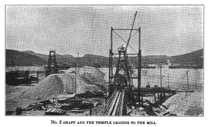


California Rand No. 2 Mine, Red Mountain [town], Rand Mining District, San Bernardino County, California, USA