The Bere Peninsula Silver-Lead Mines ~ Part I
Last Updated: 16th Nov 2007By Virginia Maine
This describes a circular walk on the Bere Alston Peninsula taking in all the sliver-lead mine sites. The walk was made on the 29th May, 2007 and took approximately 10½ hours. Some of the time was taken up in finding the locations, following dead ends and between 4 and 5 hours was spent photographing the sites and the minerals. So if you take the same walk you may be able to shorten the time down. None of the walking was hard going and the majority of it is on public footpaths with a few small stretches of road. You should contact all landowners before leaving the footpaths and going onto any private property.
As described the walk begins and ends at Weir Quay. However an alternative would be to start and end at Bere Alston Railway station, which is practically on the route of the walk, though train times may be restrictive if you are attempting it at a single sitting. Another alternative would be to park at Lockridge (SX438665) as there is room here for several cars just beside the gate where the private lane (but public footpath) to Lockridge Farm starts, and to make the circuit in 2 parts.
A very brief history.
The mines worked 2 north-south, east dipping cross courses. The eastern cross course was worked on the peninsula in South Tamar, Furzehill, Lockridge and Tamar Valley Mines (see the attached map). To the north of the river this cross course is barren beneath Calstock. Dines2 suggests that the cross course may extend south of the river to Park Mine at Cargreen on the opposite bank. However in the description of Park Mine he goes on to note that the plan of the workings does not show a compass orientation. As a result, when the run of the main cross courses is plotted on a map by following the line of known workings, Park Mine falls equidistant between the 2 and the presence of a flat lode in Park Mine, not mentioned in connection with either of the main cross course lodes would seem to suggest that this is an independent lode. A small independent lode of low grade ore also occurs at Lopwell in the north-east of the peninsula.
The western cross course runs from Danescombe; north of Calstock, under the Tamar and has been mined on the Bere Peninsula by North and South Ward, Hancock, North Hooe & South Hooe Mines. It has been exploited southward from the latter at least to Clifton on the South bank of the Tamar.
The mines were developed initially in the 13th century when, because of the high silver content of the ore, they were managed directly by The Crown as Royal Mines. From the middle of the 14th century The Crown leased the mines to private concerns but during this medieval period only the southern part of the eastern cross course (South Tamar to Goldstreet in modern terms) was known and developed.
With royal backing and a high demand for the silver the mines were at the technological forefront of the day, with early introduction of drainage adits, suction pumps and the cutting of a leat to take water from the River Lamburn 10 miles away to provide water power.
Later (around 1690 but possibly during Elizabethan times) development began at Buttspill in the Tamar Valley Mine, on the northern end of the eastern cross course but work was also carried out reworking the earlier mines now that new technology allowed dewatering to greater depths (P. Claughton (2006), Mining History Information Pages5).
'Private development began again in the 1780s under the direction of Christopher Gullet and by 1795 Bere Ferras mine had produced 1400 tones of lead ore, which yielded 76000 ounces of silver. In 1812 yields from the lower levels of this mine were said to amount to 5 tons of ore per fathom on a lode 5 feet wide.
The largest outputs were recorded during the middle parts of the 19th century when, with the advent of steam power providing both drainage and haulage, some of the mines were developed below 200 fathoms (1200 feet). However, in most cases the quality; in terms of yield of silver per ton of ore, and quantity of the ore decreased with depth. By 1890 the mines had closed and apart from a few half-hearted attempts, mostly during the shortage years of the Great War; 1914-18, no further work below ground has since been undertaken' (A.K. Hamilton Jenkin).
In the present day one of the most appealing aspects of the mine sites and the underlying cross-courses is that they are on the line of or can be seen from public footpaths, bridleways or other public rights of way for almost their entire length.
Note 1. If you draw a line between South Tamar and Buttspill Mines and another between North Ward and North Hooe mines you have the line of the 2 north-south trending cross courses.
Note 2. On spelling. Lockridge is the name of the mine and farm. The house beside the tip is Lockeridge with the middle ‘e’.
Note 3. Where information is drawn from publish texts or online sources it is enclosed in 'quotaion marks' followed by the author's name. References are given at the end of part 2.
Mines on the Eastern Lode from South to North
South Tamar Mine ~ (also known as South Tamar Consols or Beer Alston Mine).
OS Reference: SX436644
This is not included in the walk as the notice on the gateway to the site says it is ‘Property of the MOD. Keep Out’. A second notice gives the name as ‘South Tamar Mine’ and that it was an ‘Ag/Pb mine’.
‘Worked in the early 1800s the silver content at South Tamar ran at 40 to 90oz to the ton.
In 1820 a merger linked South Tamar and South Hooe Mines under the name South Tamar Consols but in 1821 the whole was offered for sale.
South Tamar was reopened in 1846 and within a year Cowie’s Shaft was 90 fathoms deep and worked ½ mile under the river in the lower levels.
By 1851 output had risen to 80 tons in the month of December and in 1854 all levels were producing well.
On 31st august 1856 the river broke in to the mine through a clay filled fault and the lower levels were immediately flooded. Fortunately the flood took place on a Sunday when the mine was deserted and there was no loss of life. For some time a number of schemes were proposed to recover the mine and the broken ore lying in the lower levels. It is said that I.K. Brunnel was called to the mine from work on the Saltash ‘Royal Albert’ Railway Bridge. But in December the mine was abandoned without hope of restarting leaving a large amount of ore broken and waiting in the lower levels to be lifted to the surface.’
A.K. Hamilton Jenkin
‘Engine shaft is sunk to a depth of 146-fm on the 15 degree east underlie. The majority of the work extends to the south. Glynn’s shaft is 100 yards north of Engine and connects at the 70, 80 & 90-fm levels.
The silver content is said to have been 80-120oz per ton in the upper levels down to 35-40oz pre ton in the lower levels.
Recorded output as South Tamar Consols are 1849-60 7140 tons of 64% lead ore and 350 tons fluorspar. In 1852-60 262470oz silver.’
Dines H.G. 1956
The main tip is quite extensive and runs along the side of the hill for about 40m. It is composed mostly of pale yellow soft clayey shale but also includes a hard almost flinty grey rock. The presence of the soft clay-shale ties in with the circumstances surrounding the drowning of the mine when the river broke in through a clay slide.
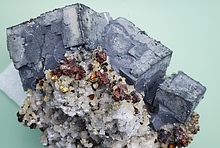
Fluorite: pale green, pale ‘honey’ yellow and clear, is fairly common. Sphalerite: dark orange-brown tarnishing to black occurs as crusts on both fluorite and chalcedony quartz, or as isolated grains in fluorite. Galena is uncommon but shows a well-defined cubic form and is associated with pyrite and sphalerite. Pyrite is uncommon but shows a radiating needle form (marcasite).
The woods surrounding this tip conceal numerous shafts and other pits. Close to the road is a shallow (approximately 5m deep) shaft that provides access to a partly flooded adit that appears to follow the strike of the lode northwards. At about 200m along there is a shaft, which extends to quite a height before being capped. The adit extends only 10m beyond the shaft.
The chimney marked on the OS map is in the corner of the field to the south-east of the site. It was deliberately demolished leaving only a semi circle of stonework no more than 10 feet high on the upslope side and a thin rubble pile.
Approximately 200m to the north of the first tip in the middle of a field is a second, only slightly smaller. This is composed of the same materials as the other. A shallow depression with an oak tree growing from it may mark the collar of the shaft seen from in the adit.
The Walk
There is space to park a car in the shade of the trees on the road beside the yacht chandlers at Weir Quay. Start the walk by turning right off the riverside road up the hill towards Cotts. The houses at the bottom of the hill on the left are the converted buildings of the lead smelting works5. Walk up past the red telephone box and the houses then turn left, back on your self onto the small track into the wood (This is a public footpath but was unmarked at this time).
Furzehill ~ (also known as Whitsam Down Mine).
OS Reference: SX436654
‘The most northerly shaft was Gourd’s, which reached 46-fm below adit, but the exact location of this and the other 5 shafts: Smith’s, Engine, Caroline’s, Charlotte’s and Church Lane, is unknown.’
Dines H.G. 1956
It is possible from reading the description of South Tamar Mine given by Dines that this first tip is actually part of that mine and not Furzehill. Regardless, the tip is immediately obvious on your right hand side behind the gorse bushes and is made up of crushed soft pale yellow clay/shale which is absolutely typical of the mine tips on the eastern cross course.
Fluorite: mostly pale yellow with some pale green, is present in small amounts.
Sphalerite: dark orange-brown tarnished black is present as pea size pieces.
There is no apparent rock dump. However, the path, which skirts around the left of the site, is made up of larger rock pieces though there is some fluorite no metal minerals are apparent.
The chimney, which is built of light grey slate country rock is in very good repair and stands in the field to the north of the site. The bushes have recently been cleared from the base, which has exposed the stoke hole on the north side. The scaffold holes are also obvious in the stonework. There are a few ruins in the bushes beside the chimney but it is not immediately apparent if this is a ruined engine house as expected or some other building.
The footpath continues uphill on the left on the hedge, which hides several rubbish filled holes, which were possibly costean pits.
Further on behind the cottages there is another small wood on the left of the path. Just over the fence is a large depression, possibly a shaft collar (Church Lane Shaft?) and behind that a large dump of fine grey sand with small pieces of shale. This could possibly be stamps waste though the area has been levelled on the top to provide a parking place so it could be brought in material.
Across the road is a country lane. Towards the far end where it turns downhill the hedgeline to the right widens and again hides a run of shaft collars (Charlotte’s Shaft (?) at the near end, Engine Shaft (?) by the road and/or costean pits, though again these have been filled with rubbish.
At the end of the lane is Furzehill wood. A track has been laid through the trees from the road on the south-east corner. This has cut through a dump (Smith’s Shaft should be about here) and the material has been used to surface the track. The dump material is mostly pale shale with fluorite: clear, white, pale to dark green and aqua blue, and crystalline quartz points.
In the wood to the south of the track is a long east-west dump. In the east this is mostly of fine grey stamps (?) sand and very overgrown with gorse and trees. To the west is an open space with more rocky material. This contains fluorite, occasional sphalerite: dark orange-brown, as crusts and galena as quite large but infrequent pieces with a well formed cubic structure associated with sphalerite and pyrite, which is iridescent in places.
To the north of the track the ground has been turned over to a mountain bike track. The only other exposed mine related evidence is in the top corner of the wood by the road where there is a large shaft collar about 5m deep. This is certainly Gourd’s shaft as described by Dines from which follow the sites of the other shafts to the south.
East Tamar Consols
‘The amalgamation in 1845 of Whitsam (later North Hooe Mine), Lockridge and Furzehill mines, worked for about 3/4 mile on the eastern lode.’
A.K. Hamilton Jenkin
Output under the name East Tamar Consols 1845-61 2,580 tons lead ore, 19,530 oz silver & 1400 tons fluorite.
Dines H.G. 1956
Lockridge ~ (also known as Goldstreet Mine).
OS Reference: SX437664
SSSI
Status: Notified under Section 28 of the Wildlife and Countryside Act 1981 (as amended).
Local Planning Authority: Devon County Council, West Devon Borough Council.
National Grid Reference: SX 438663
Area: 0.62 (ha) 1.5 (ac)
Ordnance Survey Sheet 1:50,000: 201
1:10,000: SX 46 NW
Date Notified (Under 1949 Act): œ
Date of Last Revision: œ
Date Notified (Under 1981 Act): 1989
Date of Last Revision: œ
Other Information:
A new site. Listed as of national importance in the Geological Conservation Review.
Description and Reasons for Notification:
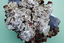
This small mine is situated towards the northern end of the large South Tamar lead lode. Although not reworked for fluorite like most local dumps it is nevertheless very rich in that mineral and sphalerite. Excellent specimens of green fluorite, sphalerite and vuggy quartz vein with carbonates can be obtained. Although there are few secondary minerals and practically no galena, the dump shows as a typical example of lead mineralisation outside the Carboniferous Limestone area.
‘No output is recorded but most likely a lead silver mine given the location. Two dumps may mark the course of the lode but shaft sites are obscured. [The dumps] contained quartz, sphalerite and fluorite but are now cleared or totally overgrown.’
Dines H.G. 1956
‘The dumps of Lockridge Mine near Bere Alston in south Devon contain rich specimens of mixed zinc, lead and copper sulphides and sulphosalts overgrowing fluorite. Wurtzite-sphalerite intergrowths showing the ‘ice-fern’ texture, which is characteristic of wurtzite, are intergrown with silver-rich tetrahedrite, tennantite and galena. Close examination suggests that most of the zinc sulphide was deposited as wurtzite and then partially altered to sphalerite. A primary hypogene origin is suggested for all of the minerals described, with the exception of anglesite.’
Ben A. Grguric & Ernest H. Nickel6.
Walk up the road beside Furzehill wood and cross into the field over the stone stile. Below the field the footpath enters the woods and immediately on the right there is a large filled shaft with another beyond that. The footpath skirts this shaft on the downslope side and then almost immediately there is another large fenced shaft on the left (north) of the path. This is totally at odds with the description offered by Dines.
Behind this shaft is an open flat platform on top of the dump. This is again composed of pale yellow fist sized pieces of shale but has a hard blocky appearance. Note the SSSI status7. Fluorite: clear, yellow and aqua green, is fairly abundant. Sphalerite: dark orange-brown with black tarnish and translucent yellow-lime green, is present as blocky lumps intermingled with fine fluorite crystals and also as crusts up to 2cm thick on fluorite or banded chalcedony quartz. Quartz also occurs as clear points. Pyrite: gritty or as radiating needles (marcasite) seeded on small pieces of rock or quartz is quite common. Galena is very uncommon but does appear as cubes possiblyu pseudomorphed into sphalerite. (Again this abundance of minerals is at odds with the description offered y Dines.)
A stream flows out from under the dumps into the woods and a path follows this but there are no further mine workings.
From here the footpath climbs the far valley side and where it crests the hill there is a shaft collar in the field and just inside the wood a brick chimney. This has the unusual feature that 2 elongated ‘windows’ are built into the brickwork and circling the chimney just below these is a ‘sill’. A few ruined walls to the west of the chimney may mark the site of the engine house.
In the wood on the slope below the chimney is a shaft collar with another at the bottom of the slope on the strike of the lode. A track runs east-west through the bottom of the wood beside the stream and at the western side of the wood it passes over the levelled top of a dump and out into the field beyond. This track is surfaced with dump material containing some fluorite. This may be the dump that Dines said was overgrown and cleared. However, cross the stream on the footpath below Lockeridge House and off to the left is an exposed part of the dump. The dump is predominantly of pale shale with some fluorite: pale yellow and sphalerite: orange-brown. Note however that 2 pieces of fine grain granite were also seen in this dump along with some building rubbish. Seemingly then it has been used as a tip in more recent times.
Tamar Valley Mine ~ (also known as Buttspill Mine, Berealston United or New Tamar Valley Mine).
OS Reference: SX437677
‘The northernmost mine on the eastern lode, just across the river from Calstock and was probably worked in Elizabethan times.
It was reopened in 1843 as Green Valley Mine but shortly after renamed Wheal Fancy by new owners. Reopened again as Berealston United Mine in 1855 it was worked mostly on the 17 and 27 fathom levels. A smelter was erected but production focused mostly on the high quality fluorspar. Outputs in 1870-6 were 95 tons lead ore, 650 oz silver and 620 tons of fluorspar. In 1885-6 as Tamar Valley Mine 90 tons of fluorspar were produced.’
A.K. Hamilton Jenkin
‘Worked in 2 parts. A small working on an adit close to the river with a 20-fm shaft. The larger working on Western Engine Shaft to a depth of 57-fms. A second shaft to the south reaches the 17-fm level and connects to Engine Shaft.
Outputs 1870-6, 95 tons 74% lead ore, 650oz silver, 20 tons pyrite, 620 tons fluorspar. As New Tamar Valley 1885-6 90 tons fluorspar.’
Dines H.G. 1956
From Lockridge follow the footpath across the field and take a look down at the river and the site of North Hooe mine. Take to the road for a short distance and then back to the footpath at Ashen. Just under the railway bridge take the left fork down the hill. On the far side of the hill an oak tree and sycamore tree mark a shaft collar with a small, totally gorse overgrown dump on the hillside.
The footpath enters the woods at the bottom of the valley. Immediately on the right is the shaft mentioned by Dines and then a run of other pits (air shafts), leading down to the mine buildings.
Stay on the footpath which appears to be turning away from the mine, then at the fork turn right down the hill to a point where it is possible to cross the stream without getting wet feet.
From the path a large tip of barren crushed grey shale can be seen. On top this dump is a leveled area at the back of which, on the boundary with the next field, is the engine house, marking Western Engine Shaft and a heavily ivy clad brick chimney.
A second tip is mostly made up of pale chunks of shale with masses of fluorite (estimated by Dines to make up 20% of the tip material) in shades of green, yellow, white and clear. Sphalerite: orange-brown, tarnishing to black is present as crusts and galena is very rarely seen in the fluorite and chalcedony quartz.
To complete the walk there are now several choices on how to reach the western cross-course. Cross back over the stream and turn immediately right down the track. This leads to the site of the workings on the river bank, though no evidence of this is now obvious. Or turn left up through the woods and then right at the fork. Both these options lead to the river and provide a scenic route along the riverside around the top of the peninsula. Alternatively retrace the route back through Buttspill wood and back onto the road at Ashen and then take the road through Helston Farm and on to South Ward. This option is less scenic though slightly quicker and does cut out North Ward Mine, though as the actual location of this mine is a little vague and there is no public right of way to the possible site it is perhaps not a loss. At this time there is no route through Buttspill (Farm) as implied by the OS map, which shows some sort of track.
The walk continues in part II
All images and original text © Chris Popham, 2007.
As described the walk begins and ends at Weir Quay. However an alternative would be to start and end at Bere Alston Railway station, which is practically on the route of the walk, though train times may be restrictive if you are attempting it at a single sitting. Another alternative would be to park at Lockridge (SX438665) as there is room here for several cars just beside the gate where the private lane (but public footpath) to Lockridge Farm starts, and to make the circuit in 2 parts.
A very brief history.
The mines worked 2 north-south, east dipping cross courses. The eastern cross course was worked on the peninsula in South Tamar, Furzehill, Lockridge and Tamar Valley Mines (see the attached map). To the north of the river this cross course is barren beneath Calstock. Dines2 suggests that the cross course may extend south of the river to Park Mine at Cargreen on the opposite bank. However in the description of Park Mine he goes on to note that the plan of the workings does not show a compass orientation. As a result, when the run of the main cross courses is plotted on a map by following the line of known workings, Park Mine falls equidistant between the 2 and the presence of a flat lode in Park Mine, not mentioned in connection with either of the main cross course lodes would seem to suggest that this is an independent lode. A small independent lode of low grade ore also occurs at Lopwell in the north-east of the peninsula.
The western cross course runs from Danescombe; north of Calstock, under the Tamar and has been mined on the Bere Peninsula by North and South Ward, Hancock, North Hooe & South Hooe Mines. It has been exploited southward from the latter at least to Clifton on the South bank of the Tamar.
The mines were developed initially in the 13th century when, because of the high silver content of the ore, they were managed directly by The Crown as Royal Mines. From the middle of the 14th century The Crown leased the mines to private concerns but during this medieval period only the southern part of the eastern cross course (South Tamar to Goldstreet in modern terms) was known and developed.
With royal backing and a high demand for the silver the mines were at the technological forefront of the day, with early introduction of drainage adits, suction pumps and the cutting of a leat to take water from the River Lamburn 10 miles away to provide water power.
Later (around 1690 but possibly during Elizabethan times) development began at Buttspill in the Tamar Valley Mine, on the northern end of the eastern cross course but work was also carried out reworking the earlier mines now that new technology allowed dewatering to greater depths (P. Claughton (2006), Mining History Information Pages5).
'Private development began again in the 1780s under the direction of Christopher Gullet and by 1795 Bere Ferras mine had produced 1400 tones of lead ore, which yielded 76000 ounces of silver. In 1812 yields from the lower levels of this mine were said to amount to 5 tons of ore per fathom on a lode 5 feet wide.
The largest outputs were recorded during the middle parts of the 19th century when, with the advent of steam power providing both drainage and haulage, some of the mines were developed below 200 fathoms (1200 feet). However, in most cases the quality; in terms of yield of silver per ton of ore, and quantity of the ore decreased with depth. By 1890 the mines had closed and apart from a few half-hearted attempts, mostly during the shortage years of the Great War; 1914-18, no further work below ground has since been undertaken' (A.K. Hamilton Jenkin).
In the present day one of the most appealing aspects of the mine sites and the underlying cross-courses is that they are on the line of or can be seen from public footpaths, bridleways or other public rights of way for almost their entire length.
Note 1. If you draw a line between South Tamar and Buttspill Mines and another between North Ward and North Hooe mines you have the line of the 2 north-south trending cross courses.
Note 2. On spelling. Lockridge is the name of the mine and farm. The house beside the tip is Lockeridge with the middle ‘e’.
Note 3. Where information is drawn from publish texts or online sources it is enclosed in 'quotaion marks' followed by the author's name. References are given at the end of part 2.
Mines on the Eastern Lode from South to North
South Tamar Mine ~ (also known as South Tamar Consols or Beer Alston Mine).
OS Reference: SX436644
This is not included in the walk as the notice on the gateway to the site says it is ‘Property of the MOD. Keep Out’. A second notice gives the name as ‘South Tamar Mine’ and that it was an ‘Ag/Pb mine’.
‘Worked in the early 1800s the silver content at South Tamar ran at 40 to 90oz to the ton.
In 1820 a merger linked South Tamar and South Hooe Mines under the name South Tamar Consols but in 1821 the whole was offered for sale.
South Tamar was reopened in 1846 and within a year Cowie’s Shaft was 90 fathoms deep and worked ½ mile under the river in the lower levels.
By 1851 output had risen to 80 tons in the month of December and in 1854 all levels were producing well.
On 31st august 1856 the river broke in to the mine through a clay filled fault and the lower levels were immediately flooded. Fortunately the flood took place on a Sunday when the mine was deserted and there was no loss of life. For some time a number of schemes were proposed to recover the mine and the broken ore lying in the lower levels. It is said that I.K. Brunnel was called to the mine from work on the Saltash ‘Royal Albert’ Railway Bridge. But in December the mine was abandoned without hope of restarting leaving a large amount of ore broken and waiting in the lower levels to be lifted to the surface.’
A.K. Hamilton Jenkin
‘Engine shaft is sunk to a depth of 146-fm on the 15 degree east underlie. The majority of the work extends to the south. Glynn’s shaft is 100 yards north of Engine and connects at the 70, 80 & 90-fm levels.
The silver content is said to have been 80-120oz per ton in the upper levels down to 35-40oz pre ton in the lower levels.
Recorded output as South Tamar Consols are 1849-60 7140 tons of 64% lead ore and 350 tons fluorspar. In 1852-60 262470oz silver.’
Dines H.G. 1956
The main tip is quite extensive and runs along the side of the hill for about 40m. It is composed mostly of pale yellow soft clayey shale but also includes a hard almost flinty grey rock. The presence of the soft clay-shale ties in with the circumstances surrounding the drowning of the mine when the river broke in through a clay slide.
Fluorite: pale green, pale ‘honey’ yellow and clear, is fairly common. Sphalerite: dark orange-brown tarnishing to black occurs as crusts on both fluorite and chalcedony quartz, or as isolated grains in fluorite. Galena is uncommon but shows a well-defined cubic form and is associated with pyrite and sphalerite. Pyrite is uncommon but shows a radiating needle form (marcasite).
The woods surrounding this tip conceal numerous shafts and other pits. Close to the road is a shallow (approximately 5m deep) shaft that provides access to a partly flooded adit that appears to follow the strike of the lode northwards. At about 200m along there is a shaft, which extends to quite a height before being capped. The adit extends only 10m beyond the shaft.
The chimney marked on the OS map is in the corner of the field to the south-east of the site. It was deliberately demolished leaving only a semi circle of stonework no more than 10 feet high on the upslope side and a thin rubble pile.
Approximately 200m to the north of the first tip in the middle of a field is a second, only slightly smaller. This is composed of the same materials as the other. A shallow depression with an oak tree growing from it may mark the collar of the shaft seen from in the adit.
The Walk
There is space to park a car in the shade of the trees on the road beside the yacht chandlers at Weir Quay. Start the walk by turning right off the riverside road up the hill towards Cotts. The houses at the bottom of the hill on the left are the converted buildings of the lead smelting works5. Walk up past the red telephone box and the houses then turn left, back on your self onto the small track into the wood (This is a public footpath but was unmarked at this time).
Furzehill ~ (also known as Whitsam Down Mine).
OS Reference: SX436654
‘The most northerly shaft was Gourd’s, which reached 46-fm below adit, but the exact location of this and the other 5 shafts: Smith’s, Engine, Caroline’s, Charlotte’s and Church Lane, is unknown.’
Dines H.G. 1956
It is possible from reading the description of South Tamar Mine given by Dines that this first tip is actually part of that mine and not Furzehill. Regardless, the tip is immediately obvious on your right hand side behind the gorse bushes and is made up of crushed soft pale yellow clay/shale which is absolutely typical of the mine tips on the eastern cross course.
Fluorite: mostly pale yellow with some pale green, is present in small amounts.
Sphalerite: dark orange-brown tarnished black is present as pea size pieces.
There is no apparent rock dump. However, the path, which skirts around the left of the site, is made up of larger rock pieces though there is some fluorite no metal minerals are apparent.
The chimney, which is built of light grey slate country rock is in very good repair and stands in the field to the north of the site. The bushes have recently been cleared from the base, which has exposed the stoke hole on the north side. The scaffold holes are also obvious in the stonework. There are a few ruins in the bushes beside the chimney but it is not immediately apparent if this is a ruined engine house as expected or some other building.
The footpath continues uphill on the left on the hedge, which hides several rubbish filled holes, which were possibly costean pits.
Further on behind the cottages there is another small wood on the left of the path. Just over the fence is a large depression, possibly a shaft collar (Church Lane Shaft?) and behind that a large dump of fine grey sand with small pieces of shale. This could possibly be stamps waste though the area has been levelled on the top to provide a parking place so it could be brought in material.
Across the road is a country lane. Towards the far end where it turns downhill the hedgeline to the right widens and again hides a run of shaft collars (Charlotte’s Shaft (?) at the near end, Engine Shaft (?) by the road and/or costean pits, though again these have been filled with rubbish.
At the end of the lane is Furzehill wood. A track has been laid through the trees from the road on the south-east corner. This has cut through a dump (Smith’s Shaft should be about here) and the material has been used to surface the track. The dump material is mostly pale shale with fluorite: clear, white, pale to dark green and aqua blue, and crystalline quartz points.
In the wood to the south of the track is a long east-west dump. In the east this is mostly of fine grey stamps (?) sand and very overgrown with gorse and trees. To the west is an open space with more rocky material. This contains fluorite, occasional sphalerite: dark orange-brown, as crusts and galena as quite large but infrequent pieces with a well formed cubic structure associated with sphalerite and pyrite, which is iridescent in places.
To the north of the track the ground has been turned over to a mountain bike track. The only other exposed mine related evidence is in the top corner of the wood by the road where there is a large shaft collar about 5m deep. This is certainly Gourd’s shaft as described by Dines from which follow the sites of the other shafts to the south.
East Tamar Consols
‘The amalgamation in 1845 of Whitsam (later North Hooe Mine), Lockridge and Furzehill mines, worked for about 3/4 mile on the eastern lode.’
A.K. Hamilton Jenkin
Output under the name East Tamar Consols 1845-61 2,580 tons lead ore, 19,530 oz silver & 1400 tons fluorite.
Dines H.G. 1956
Lockridge ~ (also known as Goldstreet Mine).
OS Reference: SX437664
SSSI
Status: Notified under Section 28 of the Wildlife and Countryside Act 1981 (as amended).
Local Planning Authority: Devon County Council, West Devon Borough Council.
National Grid Reference: SX 438663
Area: 0.62 (ha) 1.5 (ac)
Ordnance Survey Sheet 1:50,000: 201
1:10,000: SX 46 NW
Date Notified (Under 1949 Act): œ
Date of Last Revision: œ
Date Notified (Under 1981 Act): 1989
Date of Last Revision: œ
Other Information:
A new site. Listed as of national importance in the Geological Conservation Review.
Description and Reasons for Notification:
This small mine is situated towards the northern end of the large South Tamar lead lode. Although not reworked for fluorite like most local dumps it is nevertheless very rich in that mineral and sphalerite. Excellent specimens of green fluorite, sphalerite and vuggy quartz vein with carbonates can be obtained. Although there are few secondary minerals and practically no galena, the dump shows as a typical example of lead mineralisation outside the Carboniferous Limestone area.
‘No output is recorded but most likely a lead silver mine given the location. Two dumps may mark the course of the lode but shaft sites are obscured. [The dumps] contained quartz, sphalerite and fluorite but are now cleared or totally overgrown.’
Dines H.G. 1956
‘The dumps of Lockridge Mine near Bere Alston in south Devon contain rich specimens of mixed zinc, lead and copper sulphides and sulphosalts overgrowing fluorite. Wurtzite-sphalerite intergrowths showing the ‘ice-fern’ texture, which is characteristic of wurtzite, are intergrown with silver-rich tetrahedrite, tennantite and galena. Close examination suggests that most of the zinc sulphide was deposited as wurtzite and then partially altered to sphalerite. A primary hypogene origin is suggested for all of the minerals described, with the exception of anglesite.’
Ben A. Grguric & Ernest H. Nickel6.
Walk up the road beside Furzehill wood and cross into the field over the stone stile. Below the field the footpath enters the woods and immediately on the right there is a large filled shaft with another beyond that. The footpath skirts this shaft on the downslope side and then almost immediately there is another large fenced shaft on the left (north) of the path. This is totally at odds with the description offered by Dines.
Behind this shaft is an open flat platform on top of the dump. This is again composed of pale yellow fist sized pieces of shale but has a hard blocky appearance. Note the SSSI status7. Fluorite: clear, yellow and aqua green, is fairly abundant. Sphalerite: dark orange-brown with black tarnish and translucent yellow-lime green, is present as blocky lumps intermingled with fine fluorite crystals and also as crusts up to 2cm thick on fluorite or banded chalcedony quartz. Quartz also occurs as clear points. Pyrite: gritty or as radiating needles (marcasite) seeded on small pieces of rock or quartz is quite common. Galena is very uncommon but does appear as cubes possiblyu pseudomorphed into sphalerite. (Again this abundance of minerals is at odds with the description offered y Dines.)
A stream flows out from under the dumps into the woods and a path follows this but there are no further mine workings.
From here the footpath climbs the far valley side and where it crests the hill there is a shaft collar in the field and just inside the wood a brick chimney. This has the unusual feature that 2 elongated ‘windows’ are built into the brickwork and circling the chimney just below these is a ‘sill’. A few ruined walls to the west of the chimney may mark the site of the engine house.
In the wood on the slope below the chimney is a shaft collar with another at the bottom of the slope on the strike of the lode. A track runs east-west through the bottom of the wood beside the stream and at the western side of the wood it passes over the levelled top of a dump and out into the field beyond. This track is surfaced with dump material containing some fluorite. This may be the dump that Dines said was overgrown and cleared. However, cross the stream on the footpath below Lockeridge House and off to the left is an exposed part of the dump. The dump is predominantly of pale shale with some fluorite: pale yellow and sphalerite: orange-brown. Note however that 2 pieces of fine grain granite were also seen in this dump along with some building rubbish. Seemingly then it has been used as a tip in more recent times.
Tamar Valley Mine ~ (also known as Buttspill Mine, Berealston United or New Tamar Valley Mine).
OS Reference: SX437677
‘The northernmost mine on the eastern lode, just across the river from Calstock and was probably worked in Elizabethan times.
It was reopened in 1843 as Green Valley Mine but shortly after renamed Wheal Fancy by new owners. Reopened again as Berealston United Mine in 1855 it was worked mostly on the 17 and 27 fathom levels. A smelter was erected but production focused mostly on the high quality fluorspar. Outputs in 1870-6 were 95 tons lead ore, 650 oz silver and 620 tons of fluorspar. In 1885-6 as Tamar Valley Mine 90 tons of fluorspar were produced.’
A.K. Hamilton Jenkin
‘Worked in 2 parts. A small working on an adit close to the river with a 20-fm shaft. The larger working on Western Engine Shaft to a depth of 57-fms. A second shaft to the south reaches the 17-fm level and connects to Engine Shaft.
Outputs 1870-6, 95 tons 74% lead ore, 650oz silver, 20 tons pyrite, 620 tons fluorspar. As New Tamar Valley 1885-6 90 tons fluorspar.’
Dines H.G. 1956
From Lockridge follow the footpath across the field and take a look down at the river and the site of North Hooe mine. Take to the road for a short distance and then back to the footpath at Ashen. Just under the railway bridge take the left fork down the hill. On the far side of the hill an oak tree and sycamore tree mark a shaft collar with a small, totally gorse overgrown dump on the hillside.
The footpath enters the woods at the bottom of the valley. Immediately on the right is the shaft mentioned by Dines and then a run of other pits (air shafts), leading down to the mine buildings.
Stay on the footpath which appears to be turning away from the mine, then at the fork turn right down the hill to a point where it is possible to cross the stream without getting wet feet.
From the path a large tip of barren crushed grey shale can be seen. On top this dump is a leveled area at the back of which, on the boundary with the next field, is the engine house, marking Western Engine Shaft and a heavily ivy clad brick chimney.
A second tip is mostly made up of pale chunks of shale with masses of fluorite (estimated by Dines to make up 20% of the tip material) in shades of green, yellow, white and clear. Sphalerite: orange-brown, tarnishing to black is present as crusts and galena is very rarely seen in the fluorite and chalcedony quartz.
To complete the walk there are now several choices on how to reach the western cross-course. Cross back over the stream and turn immediately right down the track. This leads to the site of the workings on the river bank, though no evidence of this is now obvious. Or turn left up through the woods and then right at the fork. Both these options lead to the river and provide a scenic route along the riverside around the top of the peninsula. Alternatively retrace the route back through Buttspill wood and back onto the road at Ashen and then take the road through Helston Farm and on to South Ward. This option is less scenic though slightly quicker and does cut out North Ward Mine, though as the actual location of this mine is a little vague and there is no public right of way to the possible site it is perhaps not a loss. At this time there is no route through Buttspill (Farm) as implied by the OS map, which shows some sort of track.
The walk continues in part II
All images and original text © Chris Popham, 2007.
Article has been viewed at least 14739 times.