| Locality | Latitude | Longitude | Distance | Bearing |
|---|
| Eckelgruben, Bad Hofgastein, St. Johann im Pongau District, Salzburg, Austria | 47° 10' 18" N | 13° 6' 15" E | 0.6km (0.4 miles) | |
| Ingelsberg, Bad Hofgastein, St. Johann im Pongau District, Salzburg, Austria | 47° 10' 23" N | 13° 6' 13" E | 0.8km (0.5 miles) | |
| Gadaunern ravine, Bad Hofgastein, St. Johann im Pongau District, Salzburg, Austria | 47° 9' 7" N | 13° 7' 33" E | 2.1km (1.3 miles) | |
| Laderding Alp, Bad Hofgastein, St. Johann im Pongau District, Salzburg, Austria | 47° 11' 31" N | 13° 7' 34" E | 2.9km (1.8 miles) | |
| Vorderschneeberg, Anger valley, Bad Hofgastein, St. Johann im Pongau District, Salzburg, Austria | 47° 8' 29" N | 13° 6' 41" E | 2.9km (1.8 miles) | |
| Remsach, Bad Gastein, St. Johann im Pongau District, Salzburg, Austria | 47° 8' 28" N | 13° 7' 50" E | 3.3km (2.1 miles) | |
| Böckstein duct, SAFE Power station, Remsach, Bad Gastein, St. Johann im Pongau District, Salzburg, Austria | 47° 8' 27" N | 13° 7' 54" E | 3.4km (2.1 miles) | |
| Anger valley duct, SAFE Power station, Remsach, Bad Gastein, St. Johann im Pongau District, Salzburg, Austria | 47° 8' 27" N | 13° 7' 54" E | 3.4km (2.1 miles) | |
| Wiednergraben, Bad Hofgastein, St. Johann im Pongau District, Salzburg, Austria | 47° 11' 10" N | 13° 4' 24" E | 3.4km (2.1 miles) | |
| Gamskarkogel, Bad Hofgastein, St. Johann im Pongau District, Salzburg, Austria | 47° 9' 36" N | 13° 9' 29" E | 3.7km (2.3 miles) | |
| Talc mine, Gamskarkogel, Bad Hofgastein, St. Johann im Pongau District, Salzburg, Austria | 47° 9' 39" N | 13° 9' 30" E | 3.7km (2.3 miles) | |
| Schloss Alp, Bad Hofgastein, St. Johann im Pongau District, Salzburg, Austria | 47° 9' 21" N | 13° 3' 50" E | 3.8km (2.3 miles) | |
| Leid Alp, Bad Hofgastein, St. Johann im Pongau District, Salzburg, Austria | 47° 10' 34" N | 13° 3' 20" E | 4.2km (2.6 miles) | |
| Scheiblinggraben, Bad Gastein, St. Johann im Pongau District, Salzburg, Austria | 47° 8' 55" N | 13° 9' 35" E | 4.3km (2.7 miles) | |
| Talc Mine, Harbach, Bad Hofgastein, St. Johann im Pongau District, Salzburg, Austria | 47° 12' 12" N | 13° 8' 8" E | 4.4km (2.7 miles) | |
| Anger valley, Bad Hofgastein, St. Johann im Pongau District, Salzburg, Austria | 47° 8' 0" N | 13° 4' 54" E | 4.4km (2.7 miles) | |
| Danburite occurrence, Ardackerbach (Scheiblinggraben), Bad Gastein, St. Johann im Pongau District, Salzburg, Austria | 47° 8' 23" N | 13° 9' 8" E | 4.4km (2.8 miles) | |
| B 167 Road cut, Bad Gastein, St. Johann im Pongau District, Salzburg, Austria | 47° 7' 35" N | 13° 7' 51" E | 4.8km (3.0 miles) | |
| Harbach, Bad Hofgastein, St. Johann im Pongau District, Salzburg, Austria | 47° 13' 6" N | 13° 6' 36" E | 5.6km (3.5 miles) | |
| Grenzberg, Bad Gastein, St. Johann im Pongau District, Salzburg, Austria | 47° 7' 5" N | 13° 7' 57" E | 5.8km (3.6 miles) | |
| Aigen Alp, Grossarl, St. Johann im Pongau District, Salzburg, Austria | 47° 12' 21" N | 13° 9' 46" E | 5.8km (3.6 miles) | |
| Bellevue Alp, Böckstein, Bad Gastein, St. Johann im Pongau District, Salzburg, Austria | 47° 6' 54" N | 13° 7' 36" E | 6.0km (3.7 miles) | |
| Siebenspitze, Bad Hofgastein, St. Johann im Pongau District, Salzburg, Austria | 47° 9' 10" N | 13° 2' 1" E | 6.0km (3.7 miles) | |
| Kramkogel, Wörth, Rauris, Zell am See District, Salzburg, Austria | 47° 11' 19" N | 13° 2' 10" E | 6.1km (3.8 miles) | |
| Molybdenum adit near Hotel Europe, Bad Gastein, St. Johann im Pongau District, Salzburg, Austria | 47° 6' 55" N | 13° 8' 3" E | 6.1km (3.8 miles) | |
| Stubnerkogel, Böckstein, Bad Gastein, St. Johann im Pongau District, Salzburg, Austria | 47° 6' 42" N | 13° 5' 53" E | 6.3km (3.9 miles) | |
| Pyrkerhöhe, Bad Gastein, St. Johann im Pongau District, Salzburg, Austria | 47° 6' 42" N | 13° 8' 4" E | 6.5km (4.1 miles) | |
| Thermal water spa, Bad Gastein, St. Johann im Pongau District, Salzburg, Austria | 47° 6' 39" N | 13° 7' 59" E | 6.6km (4.1 miles) | |
| Schwarze Wand, Bad Gastein, St. Johann im Pongau District, Salzburg, Austria | 47° 6' 39" N | 13° 8' 5" E | 6.6km (4.1 miles) | |
| Spa canteen, Bad Gastein, St. Johann im Pongau District, Salzburg, Austria | 47° 6' 30" N | 13° 8' 12" E | 6.9km (4.3 miles) | |
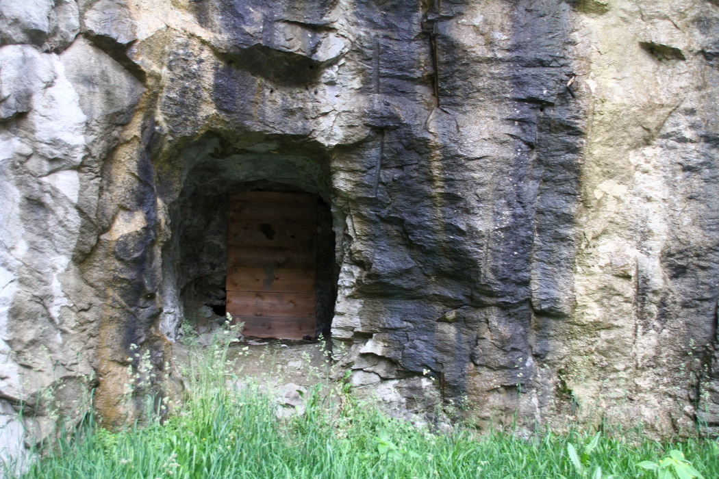


Molybdenum adit near Hotel Europe, Bad Gastein, St. Johann im Pongau District, Salzburg, Austria