| Locality | Latitude | Longitude | Distance | Bearing |
|---|
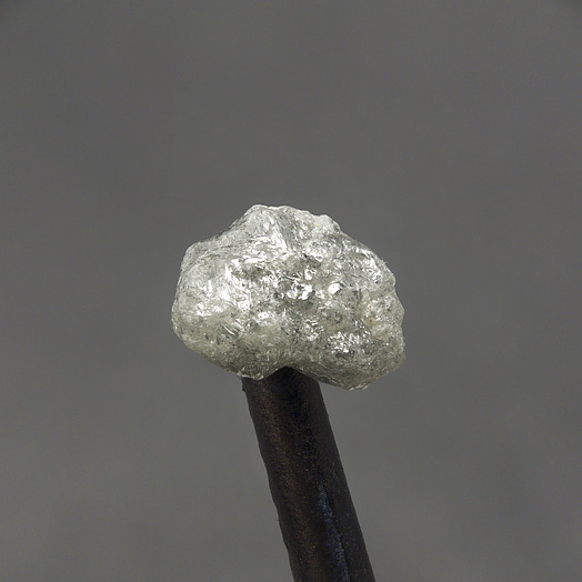
| Panna Mines, Panna, Panna District, Madhya Pradesh, India | 24° 43' 0" N | 80° 12' 0" E | 1.3km (0.8 miles) | |
| Hinota pipe, Panna Mines, Panna, Panna District, Madhya Pradesh, India | 24° 38' 59" N | 80° 1' 59" E | 17.5km (10.9 miles) | |
| Majhgawan diamond pipe, Panna Mines, Panna, Panna District, Madhya Pradesh, India | 24° 38' 30" N | 80° 1' 59" E | 17.9km (11.1 miles) | |
| Malhan, Panna District, Madhya Pradesh, India | 24° 29' 45" N | 80° 25' 46" E | 35.0km (21.7 miles) | |
| Chitrakuta (Chitrakoot), Satna district, Madhya Pradesh, India | 25° 10' 42" N | 80° 51' 55" E | 85.2km (52.9 miles) | |
| Chitrakoot Dham, Chitrakoot District, Uttar Pradesh, India | 25° 11' 59" N | 80° 54' 0" E | 89.4km (55.6 miles) | |
| Bunder Project, Nimani, Chhatarpur District, Madhya Pradesh, India | 24° 19' 30" N | 79° 17' 9" E | 101.3km (62.9 miles) | |
| Ken River, Banda District, Uttar Pradesh, India | 25° 46' 14" N | 80° 31' 32" E | 121.6km (75.5 miles) | |
| Imalia deposit, Katni district, Madhya Pradesh, India | 23° 36' 0" N | 80° 16' 0" E | 124.9km (77.6 miles) | |
| Khohar meteorite, Rewa District, Madhya Pradesh, India | 25° 6' 0" N | 81° 31' 59" E | 142.1km (88.3 miles) | |
| Futtehpur meteorite (Futtehpore meteorite; Fatehpur meteorite; Shapur meteorite; Allahabad meteorite; Bithur meteorite; Doab meteorite), Fatehpur District, Uttar Pradesh, India | 25° 56' 59" N | 80° 49' 0" E | 150.6km (93.6 miles) | |
| Neemgaon, Bhind District, Madhya Pradesh, India | 26° 28' 9" N | 78° 43' 18" E | 243.7km (151.4 miles) | |
| Khairi, Narsinghpur District, Madhya Pradesh, India | 22° 54' 27" N | 78° 45' 42" E | 248.4km (154.3 miles) | |
| Dyalpur meteorite, Sultanpur District, Uttar Pradesh, India | 26° 15' 0" N | 82° 0' 0" E | 249.0km (154.7 miles) | |
| Gadarwara, Narsinghpur District, Madhya Pradesh, India | 22° 51' 0" N | 78° 49' 0" E | 250.5km (155.6 miles) | |


Majhgawan diamond pipe, Panna Mines, Panna, Panna District, Madhya Pradesh, India