| Locality | Latitude | Longitude | Distance | Bearing |
|---|
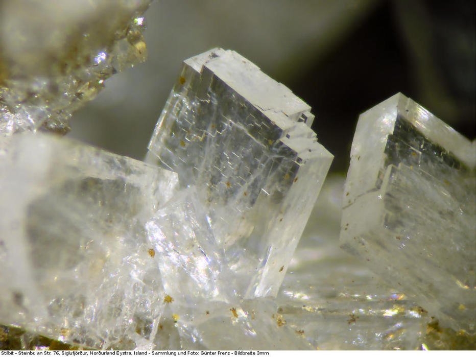
| Unnamed quarry, Siglufjörður, Fjallabyggð, Northeastern Region, Iceland | 66° 10' 3" N | 18° 54' 12" W | 2.0km (1.3 miles) | |
| Sauðanes, Siglufjörður, Fjallabyggð, Northeastern Region, Iceland | 66° 11' 4" N | 18° 57' 13" W | 4.2km (2.6 miles) | |
| Siglufjarðaskarð, Siglufjörður, Fjallabyggð, Northeastern Region, Iceland | 66° 7' 21" N | 19° 0' 3" W | 4.9km (3.0 miles) | |
| Ólafsfjarðarmúli, Dalvík, Dalvíkurbyggð, Northeastern Region, Iceland | 66° 4' 32" N | 18° 32' 29" W | 18.8km (11.7 miles) | |
| Ytrík, Dalvík, Dalvíkurbyggð, Northeastern Region, Iceland | 66° 2' 3" N | 18° 31' 30" W | 21.8km (13.6 miles) | |
| Dalvík, Dalvíkurbyggð, Northeastern Region, Iceland | 65° 58' 14" N | 18° 31' 57" W | 26.4km (16.4 miles) | |
| Stapi, Flateyjardalur, Þingeyjarsveit, Northeastern Region, Iceland | 66° 8' 28" N | 17° 55' 13" W | 44.8km (27.8 miles) | |
| Flateyjardalur, Þingeyjarsveit, Northeastern Region, Iceland | 66° 5' 59" N | 17° 53' 59" W | 46.1km (28.6 miles) | |
| Unnamed gully, Flateyjardalur, Þingeyjarsveit, Northeastern Region, Iceland | 66° 3' 11" N | 17° 53' 8" W | 47.7km (29.6 miles) | |
| Vestari Heraðsvötn, Sauðárkrókur, Sveitarfélagið Skagafjörður, Northwestern Region, Iceland | 65° 44' 53" N | 19° 32' 53" W | 53.0km (33.0 miles) | |
| Sauðárkrókur, Sveitarfélagið Skagafjörður, Northwestern Region, Iceland | 65° 44' 45" N | 19° 38' 21" W | 55.6km (34.5 miles) | |
| Road 744 road cut, Sveitarfélagið Skagafjörður, Northwestern Region, Iceland | 65° 49' 1" N | 19° 53' 21" W | 57.5km (35.7 miles) | |
| Kolbeinsey Ridge, Arctic Ocean | 66° 40' 0" N | 18° 30' 0" W | 60.4km (37.5 miles) | |
| Vaðlaheiði Tunnel, Svalbarðsstrandarhreppur, Northeastern Region, Iceland | 65° 41' 35" N | 18° 3' 15" W | 64.1km (39.8 miles) | |
| Hrafnagil, Eyjafjarðarsveit, Northeastern Region, Iceland | 65° 34' 19" N | 18° 5' 39" W | 74.3km (46.2 miles) | |
| Kotagil, Norðurádalur, Akrahreppur, Sveitarfélagið Skagafjörður, Northwestern Region, Iceland | 65° 27' 15" N | 19° 3' 25" W | 77.6km (48.2 miles) | |
| Norðurádalur, Akrahreppur, Sveitarfélagið Skagafjörður, Northwestern Region, Iceland | 65° 27' 2" N | 18° 58' 50" W | 77.8km (48.3 miles) | |
| Tjörnes, Tjörneshreppur, Northeastern Region, Iceland | 66° 12' 23" N | 17° 8' 40" W | 79.8km (49.6 miles) | |
| Ódáðahraun lava field, Northeastern Region, Iceland | 65° 9' 0" N | 17° 0' 1" W | 141.7km (88.1 miles) | |
| Tunga, Hvitarsiða, Borgarbyggð, Western Region, Iceland | 64° 43' 4" N | 20° 51' 41" W | 182.8km (113.6 miles) | |
| Húsafell, Hvitarsiða, Borgarbyggð, Western Region, Iceland | 64° 41' 50" N | 20° 52' 21" W | 185.1km (115.0 miles) | |
| Grímsvötn, Vatnajökull Glacier, Iceland | 64° 24' 29" N | 17° 20' 16" W | 207.1km (128.7 miles) | |
| Geysir, Haukadalur geothermal area, Bláskógabyggð, Southern Region, Iceland | 64° 18' 49" N | 20° 17' 58" W | 214.1km (133.0 miles) | |


Unnamed quarry, Siglufjörður, Fjallabyggð, Northeastern Region, Iceland