| Locality | Latitude | Longitude | Distance | Bearing |
|---|
| Ruan Minor, Grade-Ruan, Cornwall, England, UK | 49° 59' 37" N | 5° 10' 59" W | 0.1km (0.1 miles) | |
| Cadgwith, Ruan Minor, Grade-Ruan, Cornwall, England, UK | 49° 59' 13" N | 5° 10' 50" W | 0.7km (0.4 miles) | |
| Kildown Point, Ruan Minor, Grade-Ruan, Cornwall, England, UK | 49° 59' 21" N | 5° 10' 22" W | 0.8km (0.5 miles) | |
| Enys Head, Ruan Minor, Grade-Ruan, Cornwall, England, UK | 49° 59' 27" N | 5° 10' 11" W | 0.9km (0.6 miles) | |
| Caerleon Cove, Ruan Minor, Grade-Ruan, Cornwall, England, UK | 49° 59' 50" N | 5° 10' 14" W | 0.9km (0.6 miles) | |
| Devil's Frying Pan, Ruan Minor, Grade-Ruan, Cornwall, England, UK | 49° 59' 5" N | 5° 10' 49" W | 1.0km (0.6 miles) | |
| Carn Barrow, Ruan Minor, Grade-Ruan, Cornwall, England, UK | 49° 58' 51" N | 5° 11' 0" W | 1.4km (0.9 miles) | |
| Thorny Cliff, Kennack Cove (Kennack Sands), Kennack, Grade-Ruan, Cornwall, England, UK | 50° 0' 13" N | 5° 9' 58" W | 1.6km (1.0 miles) | |
| Ruan Major, Grade-Ruan, Cornwall, England, UK | 50° 0' 12" N | 5° 12' 17" W | 2.0km (1.2 miles) | |
| Kennack Cove (Kennack Sands), Kennack, Grade-Ruan, Cornwall, England, UK | 50° 0' 20" N | 5° 9' 42" W | 2.0km (1.2 miles) | |
| Eastern Cliff, Kennack Cove (Kennack Sands), Kennack, Grade-Ruan, Cornwall, England, UK | 50° 0' 21" N | 5° 9' 38" W | 2.1km (1.3 miles) | |
| The Caerverracks, Kennack Cove (Kennack Sands), Kennack, Grade-Ruan, Cornwall, England, UK | 50° 0' 21" N | 5° 9' 36" W | 2.1km (1.3 miles) | |
| Kennack, Grade-Ruan, Cornwall, England, UK | 50° 0' 27" N | 5° 9' 40" W | 2.2km (1.4 miles) | |
| Gwendreath Quarry, Kennack, Grade-Ruan, Cornwall, England, UK | 50° 0' 34" N | 5° 9' 49" W | 2.2km (1.4 miles) | |
| Pen Voose Cove (Parn Voose Cove), Landewednack, Cornwall, England, UK | 49° 58' 24" N | 5° 11' 18" W | 2.2km (1.4 miles) | |
| The Balk, Landewednack, Cornwall, England, UK | 49° 58' 18" N | 5° 11' 17" W | 2.5km (1.5 miles) | |
| Gwenter (Gwinter; Gwendra), St Keverne, Cornwall, England, UK | 50° 1' 5" N | 5° 9' 18" W | 3.4km (2.1 miles) | |
| Spernic Cove, St Keverne, Cornwall, England, UK | 50° 0' 26" N | 5° 8' 15" W | 3.5km (2.2 miles) | |
| Pen Olver, Landewednack, Cornwall, England, UK | 49° 57' 42" N | 5° 11' 26" W | 3.6km (2.2 miles) | |
| Housel Bay, Landewednack, Cornwall, England, UK | 49° 57' 45" N | 5° 11' 51" W | 3.6km (2.2 miles) | |
| Holestrow quarry, Landewednack, Cornwall, England, UK | 49° 58' 21" N | 5° 13' 16" W | 3.6km (2.2 miles) | |
| Pentreath Beach, Landewednack, Cornwall, England, UK | 49° 58' 9" N | 5° 13' 3" W | 3.7km (2.3 miles) | |
| Caerthillian Cove, Landewednack, Cornwall, England, UK | 49° 57' 59" N | 5° 12' 57" W | 3.8km (2.4 miles) | |
| Holseer Cove, Landewednack, Cornwall, England, UK | 49° 57' 54" N | 5° 12' 56" W | 4.0km (2.5 miles) | |
| Kynance Cove, Landewednack, Cornwall, England, UK | 49° 58' 30" N | 5° 13' 49" W | 4.0km (2.5 miles) | |
| Lizard Point, Landewednack, Cornwall, England, UK | 49° 57' 36" N | 5° 12' 23" W | 4.1km (2.5 miles) | |
| Pistil Ogo, Landewednack, Cornwall, England, UK | 49° 57' 34" N | 5° 12' 37" W | 4.2km (2.6 miles) | |
| South Wheal Treasure (South Wheal Treasury), Grade-Ruan, Cornwall, England, UK | 50° 1' 58" N | 5° 11' 18" W | 4.4km (2.7 miles) | |
| Gew Graze (Gue Graze), Mullion, Cornwall, England, UK | 49° 59' 0" N | 5° 14' 31" W | 4.4km (2.8 miles) | |
| Wheal Downas, St Keverne, Cornwall, England, UK | 50° 0' 37" N | 5° 7' 21" W | 4.7km (2.9 miles) | |
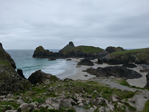


Kynance Cove, Landewednack, Cornwall, England, UK