| Locality | Latitude | Longitude | Distance | Bearing |
|---|
| Bampfylde Mine (Prince Regent Mine; Poltimore Mine; North Molton copper mine), North Molton, North Devon, Devon, England, UK | 51° 4' 48" N | 3° 48' 8" W | 2.9km (1.8 miles) | |
| New Florence Mine, North Molton, North Devon, Devon, England, UK | 51° 5' 13" N | 3° 47' 26" W | 3.7km (2.3 miles) | |
| Coal Pits, Exmoor (civil parish), Somerset West and Taunton, Somerset, England, UK | 51° 5' 32" N | 3° 42' 16" W | 7.9km (4.9 miles) | |
| West Buckland, North Devon, Devon, England, UK | 51° 3' 56" N | 3° 55' 4" W | 8.4km (5.2 miles) | |
| High Down Quarry, West Buckland, North Devon, Devon, England, UK | 51° 2' 38" N | 3° 55' 30" W | 8.9km (5.5 miles) | |
| Wheal Eliza (Wheal Maria), Simonsbath, Exmoor (civil parish), Somerset West and Taunton, Somerset, England, UK | 51° 7' 45" N | 3° 44' 17" W | 9.4km (5.8 miles) | |
| Bestridge quarry, Swimbridge, North Devon, Devon, England, UK | 51° 3' 1" N | 3° 57' 47" W | 11.5km (7.1 miles) | |
| Hoaroak Hill (Oare Oak Hill), Exmoor (civil parish), Somerset West and Taunton, Somerset, England, UK | 51° 10' 8" N | 3° 48' 28" W | 12.8km (8.0 miles) | |
| East Combe Mine (Coombe Valley Consols; Swymbridge Mine), Swimbridge, North Devon, Devon, England, UK | 51° 2' 53" N | 3° 59' 14" W | 13.2km (8.2 miles) | |
| Venn Quarry, Landkey, North Devon, Devon, England, UK | 51° 3' 24" N | 4° 1' 18" W | 15.6km (9.7 miles) | |
| Downrew Quarry, Bishop's Tawton, North Devon, Devon, England, UK | 51° 2' 47" N | 4° 1' 23" W | 15.7km (9.7 miles) | |
| Unnamed Mine Adit, Bishop's Tawton, North Devon, Devon, England, UK | 51° 2' 48" N | 4° 1' 30" W | 15.8km (9.8 miles) | |
| Overton Quarry, Bishop's Tawton, North Devon, Devon, England, UK | 51° 2' 48" N | 4° 2' 12" W | 16.6km (10.3 miles) | |
| Codden Hill Quarry, Bishop's Tawton, North Devon, Devon, England, UK | 51° 2' 55" N | 4° 2' 32" W | 17.0km (10.6 miles) | |
| Eisen Hill Mines (incl. Molds Mine; Hoe Combe Mine), Winford, North Somerset, England, UK | 51° 7' 24" N | 3° 34' 2" W | 17.9km (11.1 miles) | |
| Viveham Mine, East Down, North Devon, Devon, England, UK | 51° 7' 48" N | 4° 2' 43" W | 19.2km (11.9 miles) | |
| Lee Bay, Martinhoe, North Devon, Devon, England, UK | 51° 13' 39" N | 3° 52' 30" W | 20.0km (12.4 miles) | |
| Hollerday Hill, Lynton, North Devon, Devon, England, UK | 51° 13' 56" N | 3° 50' 26" W | 20.1km (12.5 miles) | |
| Wringcliff Bay, Lynton, North Devon, Devon, England, UK | 51° 13' 52" N | 3° 51' 33" W | 20.2km (12.5 miles) | |
| Woody Bay, Martinhoe, North Devon, Devon, England, UK | 51° 13' 29" N | 3° 53' 42" W | 20.2km (12.5 miles) | |
| Crock Point, Lee Bay, Martinhoe, North Devon, Devon, England, UK | 51° 13' 44" N | 3° 52' 40" W | 20.2km (12.6 miles) | |
| West Woody Bay, Woody Bay, Martinhoe, North Devon, Devon, England, UK | 51° 13' 34" N | 3° 54' 1" W | 20.4km (12.7 miles) | |
| Desolation Point, Countisbury, Lynton, North Devon, Devon, England, UK | 51° 14' 10" N | 3° 44' 52" W | 20.6km (12.8 miles) | |
| Countisbury Beach, Countisbury, Lynton, North Devon, Devon, England, UK | 51° 14' 22" N | 3° 46' 35" W | 20.7km (12.9 miles) | |
| Glenthorne Beach, Culbone, Oare, Somerset West and Taunton, Somerset, England, UK | 51° 13' 54" N | 3° 42' 26" W | 20.8km (12.9 miles) | |
| Culbone, Oare, Somerset West and Taunton, Somerset, England, UK | 51° 13' 16" N | 3° 39' 33" W | 21.0km (13.1 miles) | |
| Lancecombe Mine, Exton, Somerset West and Taunton, Somerset, England, UK | 51° 6' 42" N | 3° 30' 39" W | 21.1km (13.1 miles) | |
| Foreland Cliffs (incl. Foreland Point), Countisbury, Lynton, North Devon, Devon, England, UK | 51° 14' 41" N | 3° 47' 7" W | 21.3km (13.2 miles) | |
| Weekfield Mine, Exton, Somerset West and Taunton, Somerset, England, UK | 51° 6' 37" N | 3° 30' 25" W | 21.3km (13.3 miles) | |
| Aller Park Mine, Porlock, Somerset West and Taunton, Somerset, England, UK | 51° 12' 25" N | 3° 36' 43" W | 21.4km (13.3 miles) | |
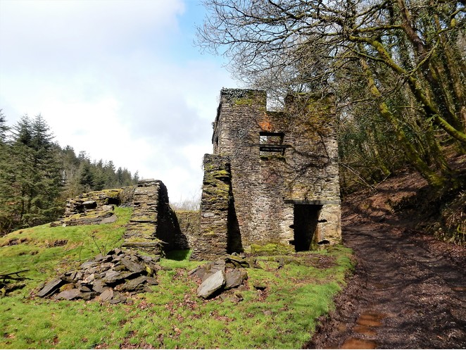


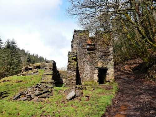


Bampfylde Mine, North Molton, North Devon, Devon, England, UK