| Locality | Latitude | Longitude | Distance | Bearing |
|---|
| Aughrim Quarry, Aughrim Hill, Kilkeel, County Down, Northern Ireland, UK | 54° 5' 42" N | 6° 2' 4" W | 5.9km (3.7 miles) | |
| Slieve Binnian (Sliabh Binneáin), Mourne Mountains, County Down, Northern Ireland, UK | 54° 8' 33" N | 5° 58' 46" W | 9.0km (5.6 miles) | |
| Pigeon Rock Mountain, Mourne Mountains, County Down, Northern Ireland, UK | 54° 8' 28" N | 6° 3' 50" W | 11.0km (6.8 miles) | |
| White Water, Pigeon Rock Mountain, Mourne Mountains, County Down, Northern Ireland, UK | 54° 9' 29" N | 6° 3' 22" W | 12.3km (7.6 miles) | |
| Slieve Bearnagh, Mourne Mountains, County Down, Northern Ireland, UK | 54° 11' 3" N | 5° 59' 18" W | 13.6km (8.5 miles) | |
| Diamond Rocks, Mourne Mountains, County Down, Northern Ireland, UK | 54° 11' 37" N | 5° 57' 59" W | 14.6km (9.1 miles) | |
| Slieve Meelmore, Mourne Mountains, County Down, Northern Ireland, UK | 54° 11' 32" N | 5° 59' 55" W | 14.6km (9.1 miles) | |
| Slievenamiskan, Spelga, Mourne Mountains, County Down, Northern Ireland, UK | 54° 10' 39" N | 6° 4' 16" W | 14.6km (9.1 miles) | |
| Lindsay's Leap, Newcastle, Mourne Mountains, County Down, Northern Ireland, UK | 54° 11' 35" N | 5° 54' 1" W | 15.1km (9.4 miles) | |
| Rosstrevor, County Down, Northern Ireland, UK | 54° 6' 2" N | 6° 12' 1" W | 16.1km (10.0 miles) | |
| Barnavave, Carlingford, Louth County, Leinster, Ireland | 54° 1' 36" N | 6° 12' 18" W | 16.3km (10.1 miles) | |
| Wee Roosley quarry, Mourne Mountains, County Down, Northern Ireland, UK | 54° 9' 28" N | 6° 9' 23" W | 16.5km (10.3 miles) | |
| Carlingford Mountain, Carlingford, Louth County, Leinster, Ireland | 54° 2' 39" N | 6° 13' 5" W | 16.8km (10.4 miles) | |
| Gruggandoo, Mourne Mountains, County Down, Northern Ireland, UK | 54° 9' 50" N | 6° 9' 47" W | 17.3km (10.7 miles) | |
| Newcastle, Mourne Mountains, County Down, Northern Ireland, UK | 54° 12' 54" N | 5° 53' 22" W | 17.6km (10.9 miles) | |
| Forkhill quarry, Co. Armagh, Northern Ireland, UK | 54° 4' 59" N | 6° 27' 45" W | 32.7km (20.3 miles) | |
| Silverbridge quarries, Co. Armagh, Northern Ireland, UK | 54° 4' 35" N | 6° 31' 2" W | 36.2km (22.5 miles) | |
| Cullyhanna Road quarry, Newtownhamilton, Co. Armagh, Northern Ireland, UK | 54° 9' 36" N | 6° 35' 1" W | 41.9km (26.0 miles) | |
| Newtownhamilton, Co. Armagh, Northern Ireland, UK | 54° 11' 25" N | 6° 34' 32" W | 42.4km (26.3 miles) | |
| Loughran Rock Industries quarry, Newtownhamilton, Co. Armagh, Northern Ireland, UK | 54° 14' 13" N | 6° 35' 2" W | 44.9km (27.9 miles) | |
| Unnamed quarry, Newtownhamilton, Co. Armagh, Northern Ireland, UK | 54° 15' 2" N | 6° 35' 15" W | 45.7km (28.4 miles) | |
| Portaferry dike, County Down, Northern Ireland, UK | 54° 22' 20" N | 5° 29' 37" W | 46.0km (28.6 miles) | |
| Cootes Quarry, Armagh City, Banbridge and Craigavon, Co. Armagh, Northern Ireland, UK | 54° 18' 23" N | 6° 34' 58" W | 48.6km (30.2 miles) | |
| Cootes Concrete Products quarry, Markethill, Co. Armagh, Northern Ireland, UK | 54° 18' 24" N | 6° 35' 3" W | 48.7km (30.3 miles) | |
| Carrickmacross, Carrickmacross-Castleblayney Municipal District, Monaghan County, Ulster, Ireland | 53° 58' 35" N | 6° 43' 9" W | 50.3km (31.3 miles) | |
| Trummery Quarry, Castle Robin, Co. Antrim, Northern Ireland, UK | 54° 30' 2" N | 6° 11' 26" W | 50.9km (31.7 miles) | |
| Unnamed quarry, Meath County, Leinster, Ireland | 53° 54' 3" N | 6° 43' 56" W | 53.4km (33.2 miles) | |
| Annaglogh Mine, Annayalla, Clontibret mining district, Monaghan Municipal District, Monaghan County, Ulster, Ireland | 54° 11' 15" N | 6° 45' 45" W | 53.9km (33.5 miles) | |
| Gypsum quarry, Carrickmacross, Carrickmacross-Castleblayney Municipal District, Monaghan County, Ulster, Ireland | 53° 56' 23" N | 6° 46' 1" W | 54.3km (33.7 miles) | |
| White Mountain Quarry, Belfast, Co. Antrim, Northern Ireland, UK | 54° 32' 41" N | 6° 5' 26" W | 54.3km (33.7 miles) | |


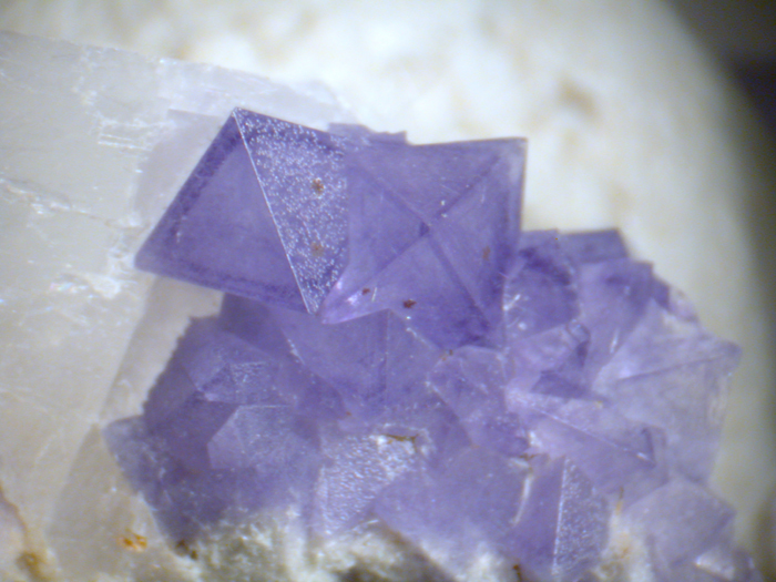


Aughrim Quarry, Aughrim Hill, Kilkeel, County Down, Northern Ireland, UK