| Locality | Latitude | Longitude | Distance | Bearing |
|---|
| Los Cobalt Mines, Los, Ljusdal, Gävleborg County, Sweden | 61° 44' 31" N | 15° 9' 22" E | 1.0km (0.6 miles) | |
| Los, Ljusdal, Gävleborg County, Sweden | 61° 44' 11" N | 15° 10' 8" E | 1.5km (0.9 miles) | |
| Nätsjö mine, Ljusdal, Gävleborg County, Sweden | 61° 42' 2" N | 15° 8' 47" E | 5.6km (3.5 miles) | |
| Mansjöberg Limestone Quarries, Los, Ljusdal, Gävleborg County, Sweden | 61° 35' 15" N | 15° 18' 5" E | 19.4km (12.1 miles) | |
| Mansjöberg Fe Mine, Los, Ljusdal, Gävleborg County, Sweden | 61° 35' 15" N | 15° 18' 8" E | 19.4km (12.1 miles) | |
| Loberget, Ovanåker, Gävleborg County, Sweden | 61° 32' 25" N | 15° 22' 47" E | 25.9km (16.1 miles) | |
| Snuggens copper mine, Ljusdal, Gävleborg County, Sweden | 61° 42' 31" N | 15° 43' 0" E | 29.3km (18.2 miles) | |
| Kringeltjärn, Voxna, Ovanåker, Gävleborg County, Sweden | 61° 24' 36" N | 15° 37' 1" E | 44.7km (27.8 miles) | |
| Lillhärdal, Härjedalen, Jämtland County, Sweden | 61° 51' 2" N | 14° 4' 27" E | 58.5km (36.3 miles) | |
| Storkullen prospect, Överturingen, Ånge, Västernorrland County, Sweden | 62° 16' 28" N | 15° 0' 22" E | 58.9km (36.6 miles) | |
| Enåsen Mine, Ljusdal, Gävleborg County, Sweden | 62° 17' 11" N | 15° 22' 14" E | 60.6km (37.7 miles) | |
| Märrviken, Ånge, Västernorrland County, Sweden | 62° 17' 40" N | 15° 3' 2" E | 60.8km (37.8 miles) | |
| Överhogdal, Härjedalen, Jämtland County, Sweden | 62° 16' 18" N | 14° 48' 18" E | 61.0km (37.9 miles) | |
| Mossbodarna quartz quarry, Överhogdal, Härjedalen, Jämtland County, Sweden | 62° 20' 57" N | 14° 48' 55" E | 69.1km (42.9 miles) | |
| Kallholsfors, Orsa, Dalarna County, Sweden | 61° 9' 57" N | 14° 42' 3" E | 69.5km (43.2 miles) | |
| Gåcktjärn Mine, Ljusdal, Gävleborg County, Sweden | 61° 58' 0" N | 16° 29' 29" E | 73.6km (45.7 miles) | |
| Härjåstugan, Härjedalen, Jämtland County, Sweden | 61° 48' 35" N | 13° 45' 57" E | 73.9km (45.9 miles) | |
| Sumåssjön, Ljusdal, Gävleborg County, Sweden | 61° 57' 6" N | 16° 34' 12" E | 77.0km (47.8 miles) | |
| Osmundsberget, Rättvik, Dalarna County, Sweden | 61° 2' 57" N | 15° 12' 0" E | 77.9km (48.4 miles) | |
| Dellen impact structure, Gävleborg County, Sweden | 61° 51' 0" N | 16° 38' 59" E | 78.7km (48.9 miles) | |
| Överturingen, Ånge, Västernorrland County, Sweden | 62° 27' 6" N | 14° 55' 0" E | 79.1km (49.2 miles) | |
| Siljan Ring (Siljan Impact Crater; Siljan impact structure; Siljan astrobleme), Mora, Dalarna County, Sweden | 61° 2' 43" N | 14° 54' 33" E | 79.5km (49.4 miles) | |
| Aggtjärn Mines, Ljusdal, Gävleborg County, Sweden | 61° 57' 26" N | 16° 37' 17" E | 79.7km (49.5 miles) | |
| Boda, Rättvik, Dalarna County, Sweden | 61° 0' 23" N | 15° 12' 57" E | 82.7km (51.4 miles) | |
| Storharn mine, Älvdalen, Dalarna County, Sweden | 61° 14' 15" N | 14° 1' 23" E | 83.2km (51.7 miles) | |
| Solberga, Boda, Rättvik, Dalarna County, Sweden | 60° 59' 1" N | 15° 12' 59" E | 85.2km (53.0 miles) | |
| Stakholmen quarry, Hassela, Nordanstig, Gävleborg County, Sweden | 62° 8' 19" N | 16° 37' 8" E | 87.4km (54.3 miles) | |
| Draggängarna, Rättvik, Dalarna County, Sweden | 60° 56' 54" N | 15° 6' 17" E | 89.2km (55.4 miles) | |
| Hassela, Nordanstig, Gävleborg County, Sweden | 62° 6' 29" N | 16° 42' 40" E | 90.1km (56.0 miles) | |
| Agnmyrgruvan, Sollerön island, Siljan lake, Siljan Ring (Siljan Impact Crater; Siljan impact structure; Siljan astrobleme), Mora, Dalarna County, Sweden | 60° 55' 54" N | 14° 36' 57" E | 95.6km (59.4 miles) | |


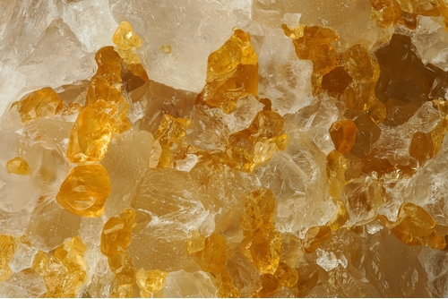


Mansjöberg Limestone Quarries, Los, Ljusdal, Gävleborg County, Sweden