| Locality | Latitude | Longitude | Distance | Bearing |
|---|
| Diabaswerk quarry, Berge, Meschede, Hochsauerlandkreis, Arnsberg, North Rhine-Westphalia, Germany | 51° 19' 10" N | 8° 10' 5" E | 6.7km (4.1 miles) | |
| Basalt AG quarry, Berge, Meschede, Hochsauerlandkreis, Arnsberg, North Rhine-Westphalia, Germany | 51° 19' 42" N | 8° 10' 37" E | 7.5km (4.7 miles) | |
| Berge, Meschede, Hochsauerlandkreis, Arnsberg, North Rhine-Westphalia, Germany | 51° 20' 0" N | 8° 9' 36" E | 8.3km (5.1 miles) | |
| Altenhellefeld, Sundern, Hochsauerlandkreis, Arnsberg, North Rhine-Westphalia, Germany | 51° 18' 52" N | 8° 5' 53" E | 8.7km (5.4 miles) | |
| Remblinghausen, Meschede, Hochsauerlandkreis, Arnsberg, North Rhine-Westphalia, Germany | 51° 18' 14" N | 8° 18' 17" E | 9.2km (5.7 miles) | |
| Hardtkopf, Hellefeld, Sundern, Hochsauerlandkreis, Arnsberg, North Rhine-Westphalia, Germany | 51° 19' 20" N | 8° 4' 41" E | 10.4km (6.4 miles) | |
| Hellefeld, Sundern, Hochsauerlandkreis, Arnsberg, North Rhine-Westphalia, Germany | 51° 19' 53" N | 8° 5' 9" E | 10.7km (6.6 miles) | |
| Cronenberg quarry, Remblinghausen, Meschede, Hochsauerlandkreis, Arnsberg, North Rhine-Westphalia, Germany | 51° 18' 2" N | 8° 19' 55" E | 10.7km (6.7 miles) | |
| Westenfeld quarry, Sundern, Hochsauerlandkreis, Arnsberg, North Rhine-Westphalia, Germany | 51° 19' 4" N | 8° 2' 49" E | 11.8km (7.3 miles) | |
| Bönkhausen, Sundern, Hochsauerlandkreis, Arnsberg, North Rhine-Westphalia, Germany | 51° 17' 8" N | 8° 1' 16" E | 12.1km (7.5 miles) | |
| Alexander Mine, Meschede, Hochsauerlandkreis, Arnsberg, North Rhine-Westphalia, Germany | 51° 18' 2" N | 8° 22' 1" E | 13.0km (8.1 miles) | |
| Churfürst Ernst Mine, Bönkhausen, Sundern, Hochsauerlandkreis, Arnsberg, North Rhine-Westphalia, Germany | 51° 17' 18" N | 8° 0' 12" E | 13.4km (8.3 miles) | |
| Berlar, Bestwig, Hochsauerlandkreis, Arnsberg, North Rhine-Westphalia, Germany | 51° 18' 52" N | 8° 22' 53" E | 14.5km (9.0 miles) | |
| Bastenberg Mine, Ramsbeck, Bestwig, Hochsauerlandkreis, Arnsberg, North Rhine-Westphalia, Germany | 51° 17' 52" N | 8° 23' 50" E | 14.9km (9.3 miles) | |
| Halbeswig diabase quarry, Berlar, Bestwig, Hochsauerlandkreis, Arnsberg, North Rhine-Westphalia, Germany | 51° 19' 36" N | 8° 23' 9" E | 15.4km (9.5 miles) | |
| Stockum quarry, Sundern, Hochsauerlandkreis, Arnsberg, North Rhine-Westphalia, Germany | 51° 17' 7" N | 7° 58' 9" E | 15.7km (9.7 miles) | |
| Ramsbeck, Bestwig, Hochsauerlandkreis, Arnsberg, North Rhine-Westphalia, Germany | 51° 18' 48" N | 8° 24' 8" E | 15.8km (9.8 miles) | |
| Willibald Mine dumps, Ramsbeck, Bestwig, Hochsauerlandkreis, Arnsberg, North Rhine-Westphalia, Germany | 51° 18' 39" N | 8° 24' 36" E | 16.2km (10.1 miles) | |
| Diabase quarry, Rühlborn, Ramsbeck, Bestwig, Hochsauerlandkreis, Arnsberg, North Rhine-Westphalia, Germany | 51° 19' 34" N | 8° 24' 20" E | 16.6km (10.3 miles) | |
| A46 Highway bridge, Uentrop, Arnsberg, Hochsauerlandkreis, Arnsberg, North Rhine-Westphalia, Germany | 51° 23' 56" N | 8° 5' 53" E | 16.6km (10.3 miles) | |
| Allendorf quarry, Allendorf, Sundern, Hochsauerlandkreis, Arnsberg, North Rhine-Westphalia, Germany | 51° 16' 17" N | 7° 57' 2" E | 16.8km (10.4 miles) | |
| Allendorf, Sundern, Hochsauerlandkreis, Arnsberg, North Rhine-Westphalia, Germany | 51° 16' 58" N | 7° 56' 57" E | 17.0km (10.6 miles) | |
| Willibald Mine, Ramsbeck, Bestwig, Hochsauerlandkreis, Arnsberg, North Rhine-Westphalia, Germany | 51° 19' 3" N | 8° 25' 20" E | 17.2km (10.7 miles) | |
| Meggen Mine, Lennestadt, Olpe, Arnsberg, North Rhine-Westphalia, Germany | 51° 7' 43" N | 8° 3' 47" E | 17.3km (10.7 miles) | |
| Bestwig quarry, Bestwig, Hochsauerlandkreis, Arnsberg, North Rhine-Westphalia, Germany | 51° 21' 3" N | 8° 24' 17" E | 17.9km (11.1 miles) | |
| Hüttebrüchen, Allendorf, Sundern, Hochsauerlandkreis, Arnsberg, North Rhine-Westphalia, Germany | 51° 16' 12" N | 7° 55' 58" E | 18.0km (11.2 miles) | |
| Grevenbrück quarry, Lennestadt, Olpe, Arnsberg, North Rhine-Westphalia, Germany | 51° 8' 53" N | 8° 0' 22" E | 18.0km (11.2 miles) | |
| Caspari Mine, Uentrop, Arnsberg, Hochsauerlandkreis, Arnsberg, North Rhine-Westphalia, Germany | 51° 24' 59" N | 8° 6' 23" E | 18.2km (11.3 miles) | |
| Föckinghausen quarry, Bestwig, Hochsauerlandkreis, Arnsberg, North Rhine-Westphalia, Germany | 51° 22' 15" N | 8° 23' 9" E | 18.2km (11.3 miles) | |
| Aurora Mine, Ramsbeck, Bestwig, Hochsauerlandkreis, Arnsberg, North Rhine-Westphalia, Germany | 51° 18' 59" N | 8° 26' 17" E | 18.2km (11.3 miles) | |
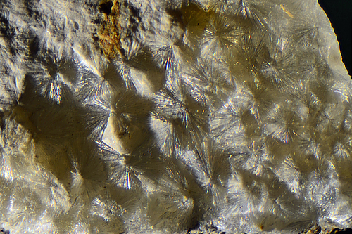
Minerals recorded nearby (within 18.2 km)
Rock types recorded nearby (within 18.2 km)
Entries shown in red are rocks recorded for this region.


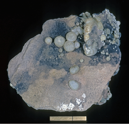


Limestone quarry, Altenhellefeld, Sundern, Hochsauerlandkreis, Arnsberg, North Rhine-Westphalia, Germany