| Locality | Latitude | Longitude | Distance | Bearing |
|---|
| U hřiště, Kovářská, Chomutov District, Ústí nad Labem Region, Czech Republic | 50° 26' 20" N | 13° 2' 45" E | 0.6km (0.4 miles) | |
| Milíře, Kovářská, Chomutov District, Ústí nad Labem Region, Czech Republic | 50° 25' 10" N | 13° 3' 6" E | 2.1km (1.3 miles) | |
| České Hamry phonolite quarry, České Hamry, Vejprty, Chomutov District, Ústí nad Labem Region, Czech Republic | 50° 26' 38" N | 13° 1' 25" E | 2.2km (1.4 miles) | |
| Štoly pod Špičákem, Kovářská, Chomutov District, Ústí nad Labem Region, Czech Republic | 50° 27' 30" N | 13° 3' 41" E | 2.3km (1.4 miles) | |
| Shaft 245, Hammerunterwiesenthal, Oberwiesenthal, Erzgebirgskreis, Saxony, Germany | 50° 27' 2" N | 13° 1' 8" E | 2.8km (1.8 miles) | |
| Straßburger Glück Mine, Niederschlag, Bärenstein, Erzgebirgskreis, Saxony, Germany | 50° 27' 29" N | 13° 1' 11" E | 3.3km (2.0 miles) | |
| Shaft 281, Hammerunterwiesenthal, Oberwiesenthal, Erzgebirgskreis, Saxony, Germany | 50° 27' 20" N | 13° 0' 57" E | 3.3km (2.1 miles) | |
| Niederschlag mine, Niederschlag, Bärenstein, Erzgebirgskreis, Saxony, Germany | 50° 27' 30" N | 13° 1' 9" E | 3.3km (2.1 miles) | |
| Magnetite Mine, Měděnec, Chomutov District, Ústí nad Labem Region, Czech Republic | 50° 25' 32" N | 13° 6' 8" E | 3.7km (2.3 miles) | |
| Mědnik Hill (Mariahilf adit), Měděnec, Chomutov District, Ústí nad Labem Region, Czech Republic | 50° 25' 28" N | 13° 6' 42" E | 4.4km (2.7 miles) | |
| Carolus Borromäus-Schacht mine, Přísečnice, Kryštofovy Hamry, Chomutov District, Ústí nad Labem Region, Czech Republic | 50° 27' 18" N | 13° 6' 40" E | 4.5km (2.8 miles) | |
| Wismuth-Zeche mine, Přísečnice, Kryštofovy Hamry, Chomutov District, Ústí nad Labem Region, Czech Republic | 50° 27' 15" N | 13° 6' 56" E | 4.7km (2.9 miles) | |
| Dorothea-Zeche mine, Přísečnice, Kryštofovy Hamry, Chomutov District, Ústí nad Labem Region, Czech Republic | 50° 27' 51" N | 13° 6' 32" E | 4.9km (3.0 miles) | |
| Fischer-Zeche mine, Přísečnice, Kryštofovy Hamry, Chomutov District, Ústí nad Labem Region, Czech Republic | 50° 27' 37" N | 13° 6' 53" E | 5.0km (3.1 miles) | |
| Jedová jáma (Drei König Zeche), Vejprty, Chomutov District, Ústí nad Labem Region, Czech Republic | 50° 28' 59" N | 13° 3' 9" E | 5.0km (3.1 miles) | |
| Rutile occurrence, Vejprty, Chomutov District, Ústí nad Labem Region, Czech Republic | 50° 29' 4" N | 13° 2' 39" E | 5.2km (3.2 miles) | |
| Vykmanov, Perštejn, Chomutov District, Ústí nad Labem Region, Czech Republic | 50° 23' 34" N | 13° 5' 2" E | 5.5km (3.4 miles) | |
| Meluzína hill, Krásný Les, Karlovy Vary District, Karlovy Vary Region, Czech Republic | 50° 23' 25" N | 13° 0' 27" E | 6.2km (3.9 miles) | |
| Stahlberg, Bärenstein, Erzgebirgskreis, Saxony, Germany | 50° 29' 39" N | 13° 1' 27" E | 6.6km (4.1 miles) | |
| Shaft 327, Neudorf, Bärenstein, Erzgebirgskreis, Saxony, Germany | 50° 29' 12" N | 12° 59' 25" E | 7.0km (4.4 miles) | |
| Na Skalách, Plavno, Krásný Les, Karlovy Vary District, Karlovy Vary Region, Czech Republic | 50° 23' 4" N | 12° 59' 39" E | 7.3km (4.5 miles) | |
| Neudorf, Bärenstein, Erzgebirgskreis, Saxony, Germany | 50° 28' 46" N | 12° 58' 20" E | 7.4km (4.6 miles) | |
| St Johannis Mine, Bärenstein, Erzgebirgskreis, Saxony, Germany | 50° 30' 26" N | 13° 1' 30" E | 7.9km (4.9 miles) | |
| Jordanstollen adit, Oberwiesenthal, Erzgebirgskreis, Saxony, Germany | 50° 24' 48" N | 12° 56' 54" E | 8.0km (4.9 miles) | |
| Tiefe Maria Stollen adit, Oberwiesenthal, Erzgebirgskreis, Saxony, Germany | 50° 24' 49" N | 12° 56' 51" E | 8.0km (5.0 miles) | |
| Bärenstein quarry, Bärenstein, Erzgebirgskreis, Saxony, Germany | 50° 30' 35" N | 13° 1' 7" E | 8.4km (5.2 miles) | |
| Christian samt Hoffnung Gottes Vereinigt Feld Mine, Cranzahl, Sehmatal, Erzgebirgskreis, Saxony, Germany | 50° 30' 47" N | 13° 0' 1" E | 9.1km (5.7 miles) | |
| Cranzahl, Sehmatal, Erzgebirgskreis, Saxony, Germany | 50° 30' 56" N | 12° 59' 39" E | 9.6km (6.0 miles) | |
| Horní Hrad, Krásný Les, Karlovy Vary District, Karlovy Vary Region, Czech Republic | 50° 20' 47" N | 13° 1' 3" E | 10.5km (6.5 miles) | |
| Benedicts Hoffnung adit, Sehma, Sehmatal, Erzgebirgskreis, Saxony, Germany | 50° 31' 37" N | 12° 59' 43" E | 10.7km (6.7 miles) | |
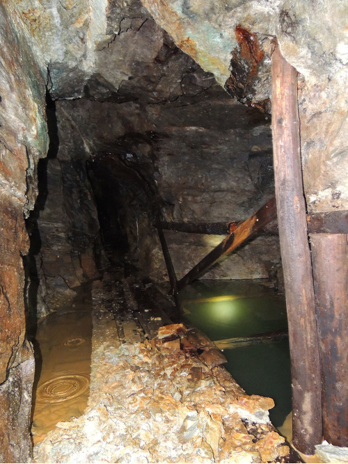
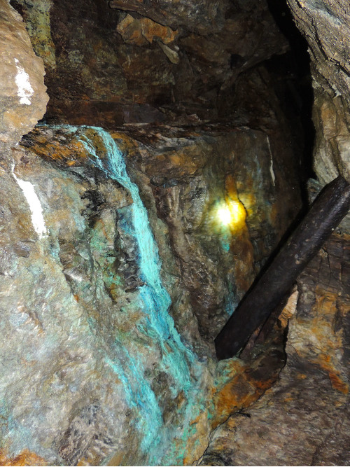

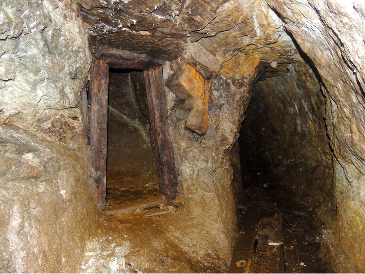
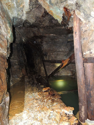


Štoly pod Špičákem, Kovářská, Chomutov District, Ústí nad Labem Region, Czech Republic