| Locality | Latitude | Longitude | Distance | Bearing |
|---|
| Grabiszyce Quarry, Grabiszyce Średnie, Gmina Leśna, Lubań County, Lower Silesian Voivodeship, Poland | 51° 1' 6" N | 15° 13' 35" E | 6.1km (3.8 miles) | |
| Hohe Hain Mountain, Raspenava, Liberec District, Liberec Region, Czech Republic | 50° 54' 56" N | 15° 9' 48" E | 6.2km (3.8 miles) | |
| Stożek Perkuna, Gmina Leśna, Lubań County, Lower Silesian Voivodeship, Poland | 51° 1' 2" N | 15° 14' 0" E | 6.2km (3.9 miles) | |
| Grodziszcze Mtn., Grabiszyce Średnie, Gmina Leśna, Lubań County, Lower Silesian Voivodeship, Poland | 51° 1' 12" N | 15° 10' 33" E | 6.3km (3.9 miles) | |
| Zgorzelec-Lubań Area, Gmina Platerówka, Lubań County, Lower Silesian Voivodeship, Poland | 51° 1' 27" N | 15° 10' 25" E | 6.8km (4.2 miles) | |
| Rapice Hill, Nové Město pod Smrkem, Liberec District, Liberec Region, Czech Republic | 50° 54' 45" N | 15° 15' 50" E | 7.3km (4.5 miles) | |
| Brusznik stream alluvials, Leśna, Gmina Leśna, Lubań County, Lower Silesian Voivodeship, Poland | 51° 0' 49" N | 15° 16' 42" E | 7.6km (4.7 miles) | |
| Wolimierz, Gmina Leśna, Lubań County, Lower Silesian Voivodeship, Poland | 50° 57' 28" N | 15° 18' 52" E | 8.0km (4.9 miles) | |
| Mount Wojkowa, Giebułtów, Gmina Mirsk, Lwówek Śląski County, Lower Silesian Voivodeship, Poland | 50° 59' 24" N | 15° 18' 59" E | 8.5km (5.3 miles) | |
| Mount Czerniawska Kopa, Czerniawa-Zdrój, Świeradów-Zdrój, Lubań County, Lower Silesian Voivodeship, Poland | 50° 54' 40" N | 15° 17' 21" E | 8.6km (5.4 miles) | |
| Marble quarry, Raspenava, Liberec District, Liberec Region, Czech Republic | 50° 53' 31" N | 15° 8' 11" E | 9.3km (5.8 miles) | |
| Słupiec (Wojkowa), Augustów, Giebułtów, Gmina Mirsk, Lwówek Śląski County, Lower Silesian Voivodeship, Poland | 50° 59' 43" N | 15° 19' 57" E | 9.8km (6.1 miles) | |
| Steel works, Frýdlant, Liberec District, Liberec Region, Czech Republic | 50° 55' 25" N | 15° 4' 3" E | 10.5km (6.5 miles) | |
| Mica slates quarry, Orłowice, Gmina Mirsk, Lwówek Śląski County, Lower Silesian Voivodeship, Poland | 50° 55' 43" N | 15° 20' 55" E | 11.1km (6.9 miles) | |
| Łomna hill, Gmina Platerówka, Lubań County, Lower Silesian Voivodeship, Poland | 51° 3' 57" N | 15° 12' 59" E | 11.2km (7.0 miles) | |
| Bożkowice, Gmina Olszyna, Lubań County, Lower Silesian Voivodeship, Poland | 51° 2' 17" N | 15° 18' 57" E | 11.4km (7.1 miles) | |
| Steinberg quarry, Gmina Platerówka, Lubań County, Lower Silesian Voivodeship, Poland | 51° 4' 17" N | 15° 12' 36" E | 11.8km (7.3 miles) | |
| Lubański Wielki Las quarry No 3, Gmina Platerówka, Lubań County, Lower Silesian Voivodeship, Poland | 51° 4' 19" N | 15° 12' 53" E | 11.9km (7.4 miles) | |
| Ostra (Czubatka), Gmina Platerówka, Lubań County, Lower Silesian Voivodeship, Poland | 51° 4' 23" N | 15° 10' 19" E | 12.2km (7.6 miles) | |
| Św. Jan mine, Krobica, Gmina Mirsk, Lwówek Śląski County, Lower Silesian Voivodeship, Poland | 50° 55' 48" N | 15° 22' 5" E | 12.3km (7.7 miles) | |
| Frýdlant-Višňová road, Višňová, Liberec District, Liberec Region, Czech Republic | 50° 57' 54" N | 15° 1' 31" E | 12.3km (7.7 miles) | |
| Łomy quarry, Gmina Platerówka, Lubań County, Lower Silesian Voivodeship, Poland | 51° 4' 36" N | 15° 12' 47" E | 12.4km (7.7 miles) | |
| Bukowa Góra quarry, Gmina Platerówka, Lubań County, Lower Silesian Voivodeship, Poland | 51° 4' 33" N | 15° 14' 56" E | 12.7km (7.9 miles) | |
| Psi Grzbiet mine, Krobica, Gmina Mirsk, Lwówek Śląski County, Lower Silesian Voivodeship, Poland | 50° 55' 43" N | 15° 22' 28" E | 12.8km (8.0 miles) | |
| Wyrwak Hill, Kamień, Gmina Mirsk, Lwówek Śląski County, Lower Silesian Voivodeship, Poland | 50° 57' 29" N | 15° 23' 13" E | 13.0km (8.1 miles) | |
| Mt. Sępia (Sępia Góra), Gmina Mirsk, Lwówek Śląski County, Lower Silesian Voivodeship, Poland | 50° 54' 32" N | 15° 22' 2" E | 13.2km (8.2 miles) | |
| Kaoline mine, Wyrwak Hill, Kamień, Gmina Mirsk, Lwówek Śląski County, Lower Silesian Voivodeship, Poland | 50° 57' 9" N | 15° 23' 28" E | 13.4km (8.3 miles) | |
| Bogata Nadzieja mine, Gierczyn, Gmina Mirsk, Lwówek Śląski County, Lower Silesian Voivodeship, Poland | 50° 55' 46" N | 15° 23' 13" E | 13.6km (8.5 miles) | |
| Marcówka basalt quarry, Mirsk, Gmina Mirsk, Lwówek Śląski County, Lower Silesian Voivodeship, Poland | 50° 58' 49" N | 15° 23' 45" E | 13.7km (8.5 miles) | |
| Św. Karol mine, Gierczyn, Gmina Mirsk, Lwówek Śląski County, Lower Silesian Voivodeship, Poland | 50° 55' 39" N | 15° 23' 16" E | 13.7km (8.5 miles) | |
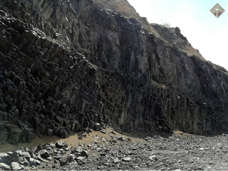
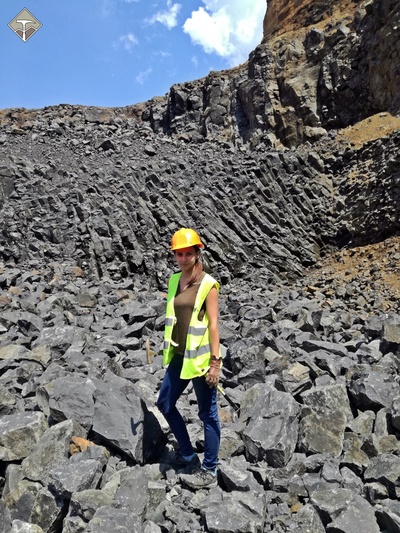


Grabiszyce Quarry, Grabiszyce Średnie, Gmina Leśna, Lubań County, Lower Silesian Voivodeship, Poland