| Locality | Latitude | Longitude | Distance | Bearing |
|---|
| Eyrs (Oris), Laas (Lasa), Vinschgau (Val Venosta), South Tyrol, Trentino-Alto Adige (Trentino-South Tyrol), Italy | 46° 37' 42" N | 10° 38' 46" E | 4.3km (2.7 miles) | |
| Stilfs deposit (Stelvio deposit), Stilfs (Stelvio), Vinschgau (Val Venosta), South Tyrol, Trentino-Alto Adige (Trentino-South Tyrol), Italy | 46° 35' 49" N | 10° 31' 49" E | 5.2km (3.3 miles) | |
| Col di Tarces (Tartscher Bühel), South Tyrol, Trentino-Alto Adige (Trentino-South Tyrol), Italy | 46° 40' 44" N | 10° 33' 34" E | 7.1km (4.4 miles) | |
| Zumpanell Mine (Sumpignolo Mine), Stilfs (Stelvio), Vinschgau (Val Venosta), South Tyrol, Trentino-Alto Adige (Trentino-South Tyrol), Italy | 46° 33' 22" N | 10° 32' 38" E | 7.8km (4.9 miles) | |
| Weißwasser quarry, Laas (Lasa), Vinschgau (Val Venosta), South Tyrol, Trentino-Alto Adige (Trentino-South Tyrol), Italy | 46° 35' 22" N | 10° 42' 0" E | 8.9km (5.6 miles) | |
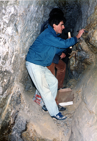
| Nesselwand quarry, Laas (Lasa), Vinschgau (Val Venosta), South Tyrol, Trentino-Alto Adige (Trentino-South Tyrol), Italy | 46° 35' 9" N | 10° 42' 4" E | 9.2km (5.7 miles) | |
| Rosim Valley, Stilfs (Stelvio), Vinschgau (Val Venosta), South Tyrol, Trentino-Alto Adige (Trentino-South Tyrol), Italy | 46° 30' 55" N | 10° 36' 24" E | 11.6km (7.2 miles) | |
| Göflaner quarry (Niederwandl quarry; Mitterwandl quarry), Göflan, South Tyrol, Trentino-Alto Adige (Trentino-South Tyrol), Italy | 46° 34' 44" N | 10° 44' 14" E | 12.0km (7.5 miles) | |
| Göflan marble quarry (Covelano marble quarry), Schlanders (Silandro), Vinschgau (Val Venosta), South Tyrol, Trentino-Alto Adige (Trentino-South Tyrol), Italy | 46° 34' 43" N | 10° 44' 14" E | 12.0km (7.5 miles) | |
| Göflan, South Tyrol, Trentino-Alto Adige (Trentino-South Tyrol), Italy | 46° 37' 16" N | 10° 45' 56" E | 13.3km (8.3 miles) | |
| Sonnenwand (Croda del Sole), Martell (Martello), Vinschgau (Val Venosta), South Tyrol, Trentino-Alto Adige (Trentino-South Tyrol), Italy | 46° 29' 42" N | 10° 38' 51" E | 14.4km (9.0 miles) | |
| Stelvio Pass, Bormio, Sondrio Province, Lombardy, Italy | 46° 31' 43" N | 10° 27' 11" E | 14.6km (9.1 miles) | |
| Ortles-Gran Zebrù northeast slope (Ortler-Königspitze northeast slope), Stilfs (Stelvio), Vinschgau (Val Venosta), South Tyrol, Trentino-Alto Adige (Trentino-South Tyrol), Italy | 46° 29' 12" N | 10° 34' 56" E | 14.7km (9.1 miles) | |
| Peder Valley, Martell (Martello), Vinschgau (Val Venosta), South Tyrol, Trentino-Alto Adige (Trentino-South Tyrol), Italy | 46° 30' 3" N | 10° 40' 42" E | 14.7km (9.1 miles) | |
| Vedretta di Solda (Suldenferner), Stilfs (Stelvio), Vinschgau (Val Venosta), South Tyrol, Trentino-Alto Adige (Trentino-South Tyrol), Italy | 46° 28' 42" N | 10° 35' 14" E | 15.6km (9.7 miles) | |
| Gran Zebrù (Königspitze), Valfurva, Sondrio Province, Lombardy, Italy | 46° 28' 42" N | 10° 34' 5" E | 15.7km (9.8 miles) | |
| Gran Zebrù Glacier (Vedretta del Gran Zebrù), Cedec Valley, Valfurva, Sondrio Province, Lombardy, Italy | 46° 28' 42" N | 10° 34' 5" E | 15.7km (9.8 miles) | |
| Monte Scorluzzo northwest slope, Bormio, Sondrio Province, Lombardy, Italy | 46° 31' 49" N | 10° 25' 31" E | 16.1km (10.0 miles) | |
| Madritsch Valley (Madriccio Valley), Martell (Martello), Vinschgau (Val Venosta), South Tyrol, Trentino-Alto Adige (Trentino-South Tyrol), Italy | 46° 29' 4" N | 10° 40' 13" E | 16.1km (10.0 miles) | |
| Borromeo Refuge, Martell (Martello), Vinschgau (Val Venosta), South Tyrol, Trentino-Alto Adige (Trentino-South Tyrol), Italy | 46° 29' 26" N | 10° 41' 28" E | 16.2km (10.1 miles) | |
| Bottiglia Pass (Königsjoch), Cedec Valley, Valfurva, Sondrio Province, Lombardy, Italy | 46° 28' 24" N | 10° 34' 38" E | 16.2km (10.1 miles) | |
| Zufritt reservoir (Gioveretto Lake), Martell (Martello), Vinschgau (Val Venosta), South Tyrol, Trentino-Alto Adige (Trentino-South Tyrol), Italy | 46° 30' 13" N | 10° 43' 22" E | 16.3km (10.1 miles) | |
| Mutspitze, Martell (Martello), Vinschgau (Val Venosta), South Tyrol, Trentino-Alto Adige (Trentino-South Tyrol), Italy | 46° 28' 38" N | 10° 39' 9" E | 16.4km (10.2 miles) | |
| Cima delle Pale Rosse, Valfurva, Sondrio Province, Lombardy, Italy | 46° 28' 18" N | 10° 33' 46" E | 16.5km (10.3 miles) | |
| Vedretta della Miniera (Cima della Miniera), Zebrù Valley, Valfurva, Sondrio Province, Lombardy, Italy | 46° 28' 7" N | 10° 33' 2" E | 17.0km (10.6 miles) | |
| Valle dei Vitelli, Bormio, Sondrio Province, Lombardy, Italy | 46° 30' 35" N | 10° 26' 9" E | 17.0km (10.6 miles) | |
| Punta di Rims, Valdidentro, Sondrio Province, Lombardy, Italy | 46° 32' 38" N | 10° 23' 46" E | 17.1km (10.6 miles) | |
| Goldrain (Coldrano), Latsch (Laces), Vinschgau (Val Venosta), South Tyrol, Trentino-Alto Adige (Trentino-South Tyrol), Italy | 46° 38' 11" N | 10° 49' 46" E | 18.3km (11.4 miles) | |
| Cima Termine (Endkopf), South Tyrol, Trentino-Alto Adige (Trentino-South Tyrol), Italy | 46° 47' 31" N | 10° 33' 55" E | 19.4km (12.0 miles) | |
| S-charl, S-charl Valley, Scuol (Schuls), Engiadina Bassa/Val Müstair Region, Grisons, Switzerland | 46° 42' 59" N | 10° 19' 57" E | 22.5km (14.0 miles) | |


Nesselwand quarry, Laas, Vinschgau, South Tyrol, Trentino-Alto Adige, Italy