| Locality | Latitude | Longitude | Distance | Bearing |
|---|
| Silver Spring, Montgomery County, Maryland, USA | 38° 59' 44" N | 77° 1' 44" W | 0.6km (0.4 miles) | |
| Bingham branch, Rock Creek Park, NW Washington, District of Columbia (Washington D.C.), USA | 38° 58' 13" N | 77° 3' 2" W | 3.1km (1.9 miles) | |
| Soapstone Valley, NW Washington, District of Columbia (Washington D.C.), USA | 38° 56' 44" N | 77° 3' 32" W | 5.8km (3.6 miles) | |
| Wheaton, Montgomery County, Maryland, USA | 39° 2' 22" N | 77° 3' 19" W | 6.0km (3.7 miles) | |
| Bethesda, Montgomery County, Maryland, USA | 38° 59' 6" N | 77° 5' 42" W | 6.0km (3.7 miles) | |
| Piney branch, Rock Creek park, NW Washington, District of Columbia (Washington D.C.), USA | 38° 56' 13" N | 77° 2' 20" W | 6.1km (3.8 miles) | |
| NW Washington, District of Columbia (Washington D.C.), USA | 38° 56' 17" N | 77° 2' 41" W | 6.1km (3.8 miles) | |
| Rock Creek Park, NW Washington, District of Columbia (Washington D.C.), USA | 38° 56' 8" N | 77° 2' 55" W | 6.4km (4.0 miles) | |
| Lamberton Branch locality, Silver Spring, Montgomery County, Maryland, USA | 39° 2' 49" N | 77° 0' 37" W | 6.4km (4.0 miles) | |
| Prince Georges Mall, Prince Georges County, Maryland, USA | 38° 58' 10" N | 76° 57' 23" W | 6.5km (4.0 miles) | |
| Gneiss outcrop, Rock Creek Park, NW Washington, District of Columbia (Washington D.C.), USA | 38° 56' 0" N | 77° 2' 58" W | 6.7km (4.1 miles) | |
| 46th street roadcut, NW Washington, District of Columbia (Washington D.C.), USA | 38° 57' 18" N | 77° 5' 26" W | 6.8km (4.3 miles) | |
| Riggs Quarry, Garrett Park, Montgomery County, Maryland, USA | 39° 1' 59" N | 77° 4' 59" W | 6.9km (4.3 miles) | |
| Rock Creek, Montgomery County, Maryland, USA | 39° 1' 17" N | 77° 5' 55" W | 7.2km (4.4 miles) | |
| Waterworks tunnel, District of Columbia (Washington D.C.), USA | 38° 55' 27" N | 77° 1' 4" W | 7.4km (4.6 miles) | |
| Kensington Mica Mine (Gilmore Mine; B. H. Warner Mine), Wheaton, Montgomery County, Maryland, USA | 39° 3' 24" N | 77° 0' 47" W | 7.4km (4.6 miles) | |
| White Oak, Montgomery County, Maryland, USA | 39° 2' 57" N | 76° 58' 49" W | 7.6km (4.7 miles) | |
| Garrett Park, Montgomery County, Maryland, USA | 39° 2' 4" N | 77° 5' 42" W | 7.7km (4.8 miles) | |
| Paint Branch, Silver Spring, Montgomery County, Maryland, USA | 39° 3' 6" N | 76° 58' 43" W | 7.9km (4.9 miles) | |
| Ayrlawn park, Bethesda, Montgomery County, Maryland, USA | 39° 0' 13" N | 77° 7' 8" W | 8.2km (5.1 miles) | |
| Skaggs Ore Bank, Prince Georges County, Maryland, USA | 38° 59' 39" N | 76° 55' 33" W | 8.6km (5.4 miles) | |
| Bethesda Mine (Miller Mine), Bethesda, Montgomery County, Maryland, USA | 38° 59' 48" N | 77° 7' 38" W | 8.8km (5.5 miles) | |
| Reed Ore Bank, Prince Georges County, Maryland, USA | 38° 59' 56" N | 76° 55' 17" W | 9.1km (5.7 miles) | |
| Buck Ore Bank, Prince Georges County, Maryland, USA | 39° 0' 18" N | 76° 55' 8" W | 9.4km (5.8 miles) | |
| Aspen hill, Montgomery County, Maryland, USA | 39° 4' 44" N | 77° 4' 24" W | 10.7km (6.6 miles) | |
| Bladensburg, Prince Georges County, Maryland, USA | 38° 55' 49" N | 76° 55' 40" W | 10.8km (6.7 miles) | |
| Constitution Avenue, District of Columbia (Washington D.C.), USA | 38° 53' 33" N | 77° 1' 57" W | 10.9km (6.8 miles) | |
| Halpine Crushed-schist Quarry, Montgomery County, Maryland, USA | 39° 4' 6" N | 77° 6' 28" W | 11.2km (6.9 miles) | |
| Huddlestone Mine, Rockville, Montgomery County, Maryland, USA | 39° 2' 14" N | 77° 8' 29" W | 11.3km (7.0 miles) | |
| B Giancola Quarry, Montgomery County, Maryland, USA | 39° 0' 46" N | 77° 9' 11" W | 11.3km (7.0 miles) | |


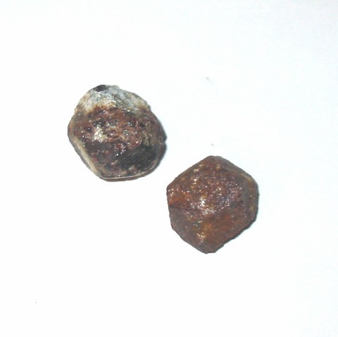
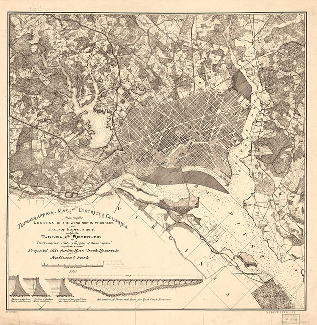


Waterworks tunnel, District of Columbia, USA