| Locality | Latitude | Longitude | Distance | Bearing |
|---|
| Portland, Middlesex County, Connecticut, USA | 41° 34' 22" N | 72° 38' 27" W | 0.1km (0.1 miles) | |
| Brainerd Quarry, Middletown, Middlesex County, Connecticut, USA | 41° 34' 29" N | 72° 38' 34" W | 0.4km (0.3 miles) | |
| Shaler & Hall Quarry, Middletown, Middlesex County, Connecticut, USA | 41° 34' 22" N | 72° 38' 40" W | 0.4km (0.3 miles) | |
| Middlesex Quarry, Middletown, Middlesex County, Connecticut, USA | 41° 34' 38" N | 72° 38' 29" W | 0.6km (0.4 miles) | |
| Middletown, Middlesex County, Connecticut, USA | 41° 33' 43" N | 72° 39' 2" W | 1.4km (0.9 miles) | |
| Middletown lead mines (Middletown Mine), Middletown, Middlesex County, Connecticut, USA | 41° 33' 32" N | 72° 36' 42" W | 2.8km (1.7 miles) | |
| State Farm Quarry (Road Metal Quarry), Middletown, Middlesex County, Connecticut, USA | 41° 33' 25" N | 72° 36' 35" W | 3.0km (1.8 miles) | |
| Riverside Quarry (Western Quarry), White Rock Mining District, Middletown, Middlesex County, Connecticut, USA | 41° 33' 28" N | 72° 36' 11" W | 3.4km (2.1 miles) | |
| White Rocks Quarry (Consolidated Quarry), White Rock Mining District, Middletown, Middlesex County, Connecticut, USA | 41° 33' 14" N | 72° 36' 1" W | 3.9km (2.4 miles) | |
| Unnamed building stone quarry, Collins Hill, Portland, Middlesex County, Connecticut, USA | 41° 35' 22" N | 72° 35' 39" W | 4.2km (2.6 miles) | |
| The Feldspar Corp. Quarry, White Rock Mining District, Middletown, Middlesex County, Connecticut, USA | 41° 33' 2" N | 72° 35' 52" W | 4.2km (2.6 miles) | |
| White Rock Mining District, Middletown, Middlesex County, Connecticut, USA | 41° 33' 10" N | 72° 35' 39" W | 4.3km (2.7 miles) | |
| Collins Hill, Portland, Middlesex County, Connecticut, USA | 41° 35' 21" N | 72° 35' 26" W | 4.5km (2.8 miles) | |
| Hale-Walker prospects, Collins Hill, Portland, Middlesex County, Connecticut, USA | 41° 35' 7" N | 72° 35' 17" W | 4.5km (2.8 miles) | |
| Strickland Quarry, Strickland pegmatite, Collins Hill, Portland, Middlesex County, Connecticut, USA | 41° 35' 31" N | 72° 35' 30" W | 4.6km (2.8 miles) | |
| Strickland pegmatite, Collins Hill, Portland, Middlesex County, Connecticut, USA | 41° 35' 33" N | 72° 35' 30" W | 4.6km (2.8 miles) | |
| Schoonmaker Mine, Strickland pegmatite, Collins Hill, Portland, Middlesex County, Connecticut, USA | 41° 35' 34" N | 72° 35' 31" W | 4.6km (2.8 miles) | |
| Carr Brook Waterfall, Collins Hill, Portland, Middlesex County, Connecticut, USA | 41° 35' 54" N | 72° 35' 36" W | 4.8km (3.0 miles) | |
| Tollgate Quarry (Tollgate Mine; Bidwell Quarry; China-stone Quarry), Middletown, Middlesex County, Connecticut, USA | 41° 31' 58" N | 72° 36' 37" W | 5.0km (3.1 miles) | |
| Unnamed quarry SE of Middletown (molybdenite locality), White Rock Mining District, Middletown, Middlesex County, Connecticut, USA | 41° 32' 44" N | 72° 35' 17" W | 5.2km (3.2 miles) | |
| Penfield Quarry (Oak Leaf Quarry), Portland, Middlesex County, Connecticut, USA | 41° 35' 47" N | 72° 34' 32" W | 6.0km (3.7 miles) | |
| Pelton's Quarry, Portland, Middlesex County, Connecticut, USA | 41° 36' 3" N | 72° 34' 36" W | 6.1km (3.8 miles) | |
| Walden Gem Quarry, Portland, Middlesex County, Connecticut, USA | 41° 37' 7" N | 72° 35' 45" W | 6.3km (3.9 miles) | |
| Gotta-Walden Prospect, Portland, Middlesex County, Connecticut, USA | 41° 37' 9" N | 72° 35' 38" W | 6.5km (4.0 miles) | |
| Bordonaro Quarry, Portland, Middlesex County, Connecticut, USA | 41° 37' 19" N | 72° 35' 47" W | 6.6km (4.1 miles) | |
| Synnott Quarry, Portland, Middlesex County, Connecticut, USA | 41° 36' 15" N | 72° 34' 19" W | 6.6km (4.1 miles) | |
| Great Hill Pond Brook pegmatite, Cobalt, East Hampton (Chatham), Middlesex County, Connecticut, USA | 41° 34' 14" N | 72° 33' 33" W | 6.7km (4.1 miles) | |
| Dripps Road, Middletown, Middlesex County, Connecticut, USA | 41° 31' 5" N | 72° 35' 59" W | 6.9km (4.3 miles) | |
| Gotta-Wannerstrom Quarry, Portland, Middlesex County, Connecticut, USA | 41° 37' 31" N | 72° 35' 47" W | 6.9km (4.3 miles) | |
| Unnamed Zeolite occurrence (1), Wadsworth Falls, Middlefield, Middlesex County, Connecticut, USA | 41° 31' 35" N | 72° 41' 44" W | 6.9km (4.3 miles) | |
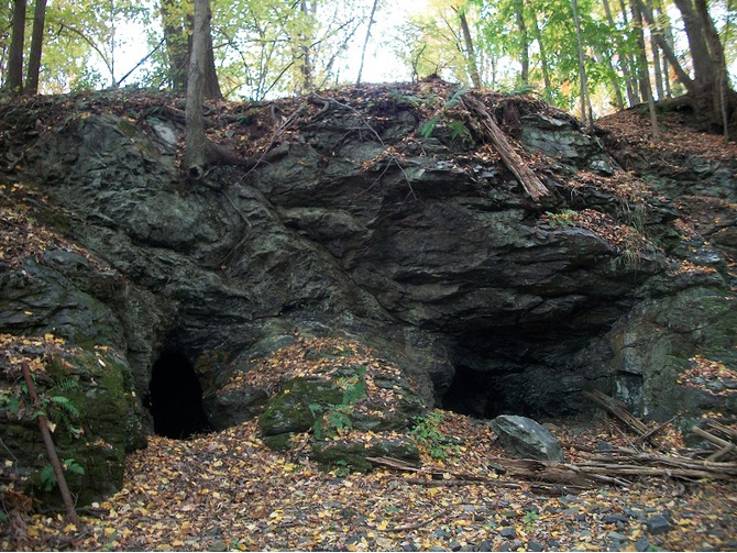
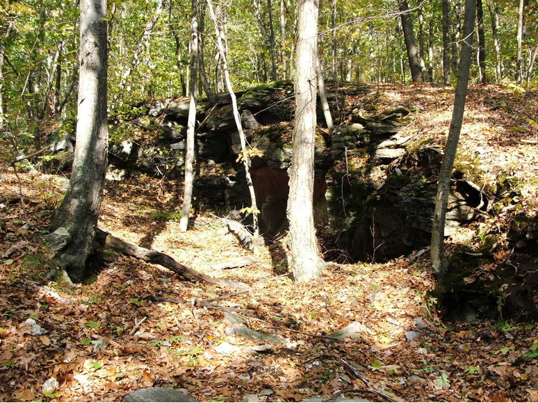


Middletown lead mines, Middletown, Middlesex County, Connecticut, USA